Download
1 / 11
110 likes | 319 Views
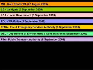
MR - Main Roads WA (27 August 2009). LG - Landgate (3 September 2009). LGA - Local Government (3 September 2009). POL - WA Police (3 September 2009). FESA - Fire & Emergency Services Authority (8 September 2009). DEC - Department of Environment & Conservation (8 September 2009).

E N D
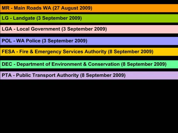
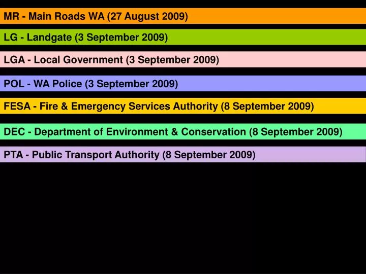
MR - Main Roads WA (27 August 2009) LG - Landgate (3 September 2009) LGA - Local Government (3 September 2009) POL - WA Police (3 September 2009) FESA - Fire & Emergency Services Authority (8 September 2009) DEC - Department of Environment & Conservation (8 September 2009) PTA - Public Transport Authority (8 September 2009)
MRWA Data • Road Asset Management • Attribute data is spatial but not stored that way • Dynamically segmented • GIS application being developed • External customers demanding access & additional features • LG Data • Spatial map product • Physical road – not cadastre casement • Integrated Dataset – MR, DEC, LGA • Migrating to Topographic DB 2010 • Official Road name • Concept roads / Proposed / Surveyed • Private roads, Access ways, DEC roads • MRWA Attributes • Speed limit • Dual carriageway (left /right) 1way not defined • Turning restriction • Height restrictions • Weight restrictions • Temporary road closure – all RD owners • LG Attributes • MR number • Road class type – Hwy/ Main/Track • Surface type • Number of lanes • Road use – bus / 2wd / 4wd • Status – operational / closed / proposed • Traffic flow – not populated • Turning restrictions • Address • MRWA Issues • Customer service obligations - driving towards a RRN • Currently don’t have a BC to capture RRN attributes • Business need to have sustainable data maintenance in place • Road Group not understanding this gap • LG Issues • MR number updates • Ongoing maintenance of RRN attributes • LGA roads included early – concept roads • DEC road naming - Geonoma • Integrity of road information
LGA Data • LGA & MRWA workflow (IRIS update) • ROMAN 1 – road asset management • ROMAN 2 – improved spatial, LGA will be doing QA / cleansing • LGA Issues • Road number (LGA amalgamations / MRWA) • Road name allocation (LG) • More responsibility with ROMAN 2 for LGA (limited resources & expertise) • LGA Needs • Improved workflow for new / proposed roads & road number process LOCAL GOVERNMENT
POL Data • LG data supplied quarterly • 2-3 week processing for Corporate RCL • 6-8 weeks processing for Dispatch RCL • Value added RCL used for high end mapping & travel analysis • Anomalies reported to LG to fix at source • POL Issues • 0 length lines • View class • POL Needs • Need for a attributed RRCL POLICE
FESA Data • LG data supplied quarterly • RCL used for Mapping, Planning Analysis, Emergency dispatch & response • Uses PSA – geocoding • Anomalies reported to LG to fix at source • SLIP EM • FESA Issues • Accurate categories / view classes • FESA Needs • Speed limit • Travel direction • Travel barriers • Topology correct (e.g. Overpasses) FESA
DEC Data • LG originally supplied RCL data • Value added but not updated to match current LG RCL • Asset manage Roads on DEC estate – core function is land management • Used for map production, spatial products & information management • Maintained as required / ESD • Strategic road data now in ROMAN (includes speed & safety hazards) – raw data • DEC Issues • DEC roads data – road names not linked • Relegated roads / restricted roads not for public • DEC Needs • Multi user access system that is spatially orientated • Workflow process between MR (ROMAN) & LG (on line topo GDB) & DEC road info DEC
PTA Data • LG RCL supplied quarterly • Value added using ESRI customised tools • Used for route descriptions, route planning, map products & route analysis • PTA Issues • 0 length lines • Changing UFI – updates • Data currency • Missing connectors • PTA Needs • Speed limit • Flow direction • Private & proposed / new roads • Turning restriction • Overpass • Median strip PTA
LGA Issues • Road number (LGA amalgamations / MRWA) • Road name allocation (LG) • More responsibility with ROMAN 2 for LGA (limited resources & expertise) • POL Issues • 0 length lines • View class • FESA Issues • Accurate categories / view classes • DEC Issues • DEC roads data – road names not linked • Relegated roads / restricted roads not for public • PTA Issues • 0 length lines • Changing UFI – updates • Data currency • Missing connectors ISSUES
LGA Needs • Improved workflow for new / proposed roads & road number process • POL Needs • Need for a attributed RRCL • FESA Needs • Speed limit • Travel direction • Travel barriers • Topology correct (e.g. Overpasses) • DEC Needs • Multi user access system that is spatially orientated • Workflow process between MR (ROMAN) & LG (on line topo GDB) & DEC road info • PTA Needs • Speed limit • Flow direction • Private & proposed / new roads • Turning restriction • Overpass • Median strip NEEDS
Minimum Routable Attributes • LG Data – topology / consistency / new roads / road class • MR Data – improved spatial representation • Multi user access for view & update of roads Data users needs: • Sustainable data maintenance procedure • Efficient data capture – lessen duplication of effort • Standardise procedures & data capture method – synchronised data • Workflow / business procedures to link in with each custodian • Data models to be complimentary, & linked through ID (Road No) Data custodians: • Share value added road data – tools, methods, information, anomaly feedback (POL, FESA, PTA, LGA – MR, LG) • Routable Attributes – LG & MR to progress as there is a need to capture FOCUS
Consolidate findings so far and start developing the BC • Focus on assessing the road centreline model, data requirements and ongoing maintenance needs, and not on ownership and distribution of the end product • Improve the maintenance and quality of existing data sets WAY FORWARD ?