Download
1 / 33
330 likes | 505 Views
The DECOMP PHYSICAL MODEL. NRC CISRERP Meeting 21 September 2009. DECOMP PHYSICAL MODEL OVERVIEW Dr. Fred Sklar Everglades Division Director South Florida Water Management District. Aquifer Storage and Recovery. Surface Water Storage Reservoir. Stormwater Treatment Areas.

E N D
The DECOMP PHYSICAL MODEL NRC CISRERP Meeting 21 September 2009
DECOMP PHYSICAL MODEL OVERVIEW Dr. Fred Sklar Everglades Division Director South Florida Water Management District
Aquifer Storage and Recovery Surface Water Storage Reservoir Stormwater Treatment Areas Seepage Management Removing Barriers to Sheetflow Operational Changes Reuse Wastewater Comprehensive Everglades Restoration Plan
CERP PROJECT Decompartmentalization (DECOMP) Considered the “heart” of Everglades Restoration, is the removal of levees and the backfilling of canals in Water Conservation Area 3 as a way to restore the hydrology of the Everglades. Construct Weirs and Culverts Levee Degradation Canal Backfill WCA-3A WCA-3B Remove Structures Raise and Bridge Tamiami Trail X X X X
At Issue • By February 2005 it was recognized by the DECOMP Project Development Team (PDT) that there were fundamental problems hindering the development of the Project Implementation Report (PIR). • Lack of consensus/uncertainty* on restoration vision. • Scientific and engineering uncertainty on how to quantify benefits of sheetflow, engineer the system to achieve sheetflow, and maintain cost effectiveness. *Uncertainty exists when two or more contradictory explanations are ventured to explain the same phenomenon.
The Solution The DECOMP Adaptive Management Plan (DAMP) • Find best restoration design for DECOMP, without compromising water supply or flood control. • Combine data mining, historical analysis, PHYSICAL MODELS, and evaluation tools. • Address specific scientific uncertainties and incorporate new information. • Use multi-agency collaborative approach (with stakeholder input). • Increase understanding of system responses to various activities. • Select optimal project alternative(s).
DAMP Physical Model • Purpose • To addresses uncertainty and constraints in Everglades restoration to assist in the DECOMP PIR. • To refine our understanding of ecological benefits to support the selection of alternative plans. • To refine evaluation performance measures. • To obtain a better scientific understanding of how “pristine” and “impacted” regions of the ecosystem will respond to hydrologic restoration.
EIS/FWCAR/ENP DECOMP - PIR DAMP FWS PAL Scoping Data Mining Management Approach Alternatives Physical Models ENP Report Passive Approach Numerical Model Review Draft CAR Initial Screening Information Requirements PM Review Final CAR Final Alternatives Monitor & Report Revised Models Revised PM’s Alternative Evaluations TSP ROD CAR- Coordination Act report EIS- Environmental Impact Statement ENP- Everglades National Park FWS- Fish and Wildlife Service PAL- Planning Aid Letter PIR- Project Implementation Report PM- Performance Measure ROD- Record of Decision TSP- Tentatively Selected Plan
DECOMP • Scientific Uncertainties • Effects of partial versus extensive backfilling of canals • Quantification of the ecological benefits of sheetflow • Ecological effects of levee modifications • Water depth and hydroperiod tolerance of tree islands • Assessment of seepage • Calibration of hydrologic models
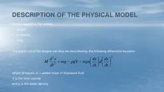
Physical Model Concept- Move water along historic flow paths from WCA-3A through controlled openings in the L-67A levee, through the “pocket”, to canal and levee modifications on the L-67C. Physical Model Design Factors- Operate within the current and future operational constraints (e.g., water depths in WCA-3B and L-29) Adhere to water quality standards set forth in the Everglades Forever Act Minimize the impact to recreation S151 Mean Phosphorus 15-20 ppb S333 Mean Phosphorus 11-12 ppb
A Brief History • Fall 2004-Concept development to use large-scale field experiments (Physical Models) to reduce DECOMP uncertainties. • January 2005-DECOMP Project Adaptive Management Strategy Development Workshop (DAMP). • February 2005- DAMP, including physical models, approach presented to Quality Review Board (QRB) (Taplin). • April 2005-DAMP presented to the NRC (Sklar) • September 2005-January 2006- DECOMP scientific uncertainty, hypothesis, and physical model development. • March 2006- “Description of the Physical Model Design Parameters” (Sklar, Newman, Hagerthey, Engel, Noe, Childers, and Trexler).
A Brief History • April 2006- DAMP concept presented to the QRB. Includes Physical Model design options with the PRIUS model being favored. • Proposed design relied on 1 Modified Water Deliveries (MWD) conveyance/seepage feature (C&SF) (S-345) • Estimated cost of $10.3 Million over 5 years • $3.4M Levee Removal and Canal Backfill (assumed MWD in place) • $6.9M Monitoring and Field Assessment • 2006-2007-Physical model design work progressed based on MWD C&SF features. This was also the period of “Bigger & Bolder” and Integrated Adaptive Restoration (IAR). • April 2007- Physical Model presented at the National Conference on Ecosystem Restoration (Sklar).
Alternative DAMP Physical Models 2006-2007 Physical ModelMetamorphosis Conceptual Pocket Experiment Designs 2005 A) B) X C) Ferrari Model Lexus Model Kia Model Prius Model v3.4 Prius Model v1 Prius Model v2
L-67A Levee L-67C Levee THE DAMP PHYSICAL MODEL February 2008 PriusModel v3.4 L-67 Pocket 3000 ft gap (complete backfill) BACI Flow-way with one 9,000 ft L-67C gap 3000 ft gap (canal plug with boat channel) 3000 ft gap (partial backfill) 3000 ft gap (no fill) Repeated Measure Flow-way Canal plug with boat channel
A Brief History • February 2008 - Physical Model design put “on-hold” due to MWD financial and legal uncertainties. • July 2008- DECOMP PDT decides to reinitiated project decoupled from MWD C&SF. • September 2008- DECOMP Physical Model (DPM) design begins. • Move forward faster • Reduce uncertainties for DECOMP PIRs 2 & 3 • Moving forward assuming $10.3M cost cap • Study design examines a pulsed-flow system • Reduced in scale
DECOMP PHYSICAL MODEL SCIENCE PLAN Dr. Scot Hagerthey Lead Environmental Scientist South Florida Water Management District
Schedule The Science Plan • National Environmental Policy Act (NEPA) • NEPA Scoping Meeting Feb 2009 • Draft EA Sep 2009 • Final EA; NEPA Complete Jan 2010 • Experimental Design • Finalize DPM Experimental Design Feb 2009 • Develop Science Plan Jun 2009 • Scientific Peer Review Sep 2009 • Design Plans and Specs • Plans and Specs Jan 2010-Apr 2011 • Installation and Testing • Pre Impact Monitoring Oct 2010-Sep 2012 • Construction Apr 2011-May 2012 • Post Impact Monitoring Oct 2012-Feb 2014 • Removal Mar 2014
DPM Science Team • Charge- Develop an experimental design to address uncertainties associated with DECOMP PIR 2 & PIR 3. • Members • SFWMD: Fred Sklar, Scot Hagerthey, Sue Newman, and Colin Saunders • ACOE: Kelly Legault and Sue Wilcox • USGS: Jud Harvey, Laurel Larsen, and Greg Noe • ENP: Vic Engel • USFWS: Kevin Palmer and Lori Miller • Contractors/Consultants: Jed Redwine, Christa Zweig, and Joel Trexler
TASKS The Science Plan • Redesign the DPM without the MOD Waters features • Determined the feasibility of addressing DECOMP uncertainties • Developed ecosystem conceptual models • Developed sets of testable hypotheses • Remain within the $10.3 million Cost Cap • ~$8 million construction; $2.3 million science • Identify constraints and assumptions • Appendices to Science Plan • Identify the physical features required for the DPM and their locations • Develop a detailed outline of the Science Plan • Statistical design • Parameter determination for each hypothesis • Methods selection • Sampling frequency and logistics • Conduct NEPA Scoping meetings • Draft Science Plan • Draft EA (Operation Plan, Engineering Plan, Science Plan)
X X X X X X X X X X X X X X X X X X X X X X X X X X X X • The Science • Plan To stay within cost cap and operational constraints the DPM was reduced in scale to a BACI flow-way and pulsed flow operations. I-75 PIR 3 –Backfill/Degrade L-68A UNCERTAINTY 1 The extent to which canals need to be Backfilled UNCERTAINTY 2 The need for sheet flow to maintain ridge and slough patterns UNCERTAINTY 3 The hydrologic and ecological effects of levee modification UNCERTAINTY 4 Hydrologic tolerances of tree islands UNCERTAINTY 5 Stage and seepage relationships UNCERTAINTY 5 Model calibration MIAMI CANAL L-67A PIR 3 – Weirs in L-67A L-67C WCA 3A X X X X PIR 2 – Backfill/Degrade Miami Canal X PIR 2 – Add S-345s Physical Model PIR 3 –Backfill/Degrade L-67C PIR 3 –Backfill /Degrade L-28/L-29 PIR 3 – Backfill L-67A WCA 3B X PIR 3 – Remove S-12s, 343s, 344 PIR 2 – Raise & Bridge East Portion of TT PIR 3 – Bridge West Portion of TT PIR 2 – Degrade L-29 Levee/Canal X X X X X X X X X X X X X X X X X X X X X X X X X
The Science Plan • Materials and Methods (Cont) • Hydrodynamics • Particle Transport • Ecology • Animal Responses • Biogeochemistry and Elemental Fluxes • Evaluating Ecological Benefits of Sheet flow • Introduction (Statement of Problem) • Scientific Hypotheses • Physical Transport (3 total) • Transport and Ridge and Slough Development (6 total) • Landscape Hypotheses (4 total) • Experimental Approach • Materials and Methods • Hydrodynamics • Particle Transport • Biological Measurements • Synthesis and Reporting • Integration with Hydrologic Models • The RASCAL Model, The Ribbon Model, The Lattice-Boltzmann Model • Executive Summary • General Introduction • Introduction • CERP and DECOMP • Uncertainties and the DECOMP Physical Model • The DECOMP Physical Model Experimental Design • Introduction • DPM Site Location and Features Description • Hydrologic Expectations • Operation Schedule • The BACI Concept • Evaluating Canal Backfilling Options • Introduction (Statement of Problem) • Scientific Hypotheses (9 total) • Experimental Approach
Constraints & Assumptions The Science Plan • Developed a Constraints Document • Operations- cannot exceed 8.5 feet NGVD in WCA-3B nor operate during hurricane season. • Water Quality- cannot violate EFA • Tree Islands- cannot do harm to tree islands • Wildlife- cannot do harm to wildlife • Conducted a Hydrologic Analysis for the feasibility of the DPM to produce velocities greater than the critical entrainment velocity of 2-3 cm/sec. • Defined the likely period of operation and detailed analysis to determine test durations and operational criteria.
Operational Window (OW) October-January Estimated 17-41 days of Operation Factors Considered: Water Quality, Stage Constraints, Hydrologic Conditions, Modeled Velocities, Environmental Impact, Operational Constraints Operation Plan submitted as part of EA Mean Monthly Predicted Velocity at S-71 Gauge Monthly Mean Stage Difference WCA-3the B-WCA-3A Mean Monthly Stage at S-71 Gauge Monthly Mean TP Concentration at S-151
Location of the DPM BACI Flow Way L-67A Culvert 750 cfs Capacity WCA-3A WCA-3B DPM Tamiami Trail L-67C Degraded Levee (3000’) L-67C Canal Backfill (1000’ per treatment) Canal Sites R &S Sites
THE DPM SCIENCE PLAN Canal Backfilling Conceptual Driver: Structure Transport Driver: Conveyance Flow transport Driver: Sheetflow transport Canal Depth as a function of backfill treatments (No backfill, partial backfill, complete backfill) Groundwater Local Velocity Profile Particle entrainment and deposition Dispersal Marsh Connectivity Canal Connectivity Primary Production Resource and Organic Matter Export to Marsh Thermal Profile Oxygen Profile Water Quality Native Fauna Organic Matter Decomposition Biogeochemistry Physical Transport Exotic Fauna Ecology
THE DPM SCIENCE PLAN Ridge & Slough Conceptual Model Driver: Solute supply Driver: Discharge Water Table transport Subhydro Biogeochem P conc Redox Evapotranspiration Differential peat accretion VegType Hydroperiod Ridge and slough geomorphology Drag Re Particle trapping Lateral Transport of bed sediment by gravity or episodic events Local Velocity Profile Sediment distribution Sed Trans Zones of net particle entrainment and deposition Larsen et al. 2006
Hypothesis Conceptual Model Linkages THE DPM SCIENCE PLAN Examples: • SH01: A flow regime that exceeds a critical flow velocity and bed shear stress is not necessary to entrain sediment. It is expected that sustained periods (days to weeks) of flow velocities exceeding a threshold of 3 cm/sec is required to entrain and redistribute a quantity of sediment particles. The long-term cumulative effect of these flow events will result in the restoration and maintenance of the historic ridge & slough landscape. • BH03: Habitat quality (oxygen and temperature depth profiles) will not differ among backfilling treatments. The greater water depths in canals relative to marsh depths may develop different vertical profiles of ecologically important physiochemical constituents (e.g., dissolved oxygen or temperature). Of special concern is the development of waters with low dissolved oxygen concentrations (hypoxia) which could be detrimental to aquatic fauna and affect biogeochemical cycling. • Canal Backfilling • 9 hypotheses developed • 6 directly testable within DPM • 3 testable by inference • Ridge and Slough • 17 hypotheses developed • 7 directly testable within DPM • 6 testable by inference • 4 not testable
THE DPM SCIENCE PLAN BACI Statistical Design and Proposed Schedule Before After IMPACT Response variable C1-1 T1-1 Time
MEASUREMENTS THE DPM SCIENCE PLAN • Hydrology • A network of 10-15 sites for monitoring stages, water depths, flow direction, and velocity. • Hydraulics of L-67A culverts (head and tail water stages and cfs). • Synoptic mapping of water depth and velocity in conjunction with flow manipulations. • Vegetation mapping for hydraulic resistance. • Tracer studies to map direction and velocity of surface water flows. • Simultaneous SF6 tracer and dye releases • Intensive monitoring at treatment and control canal backfilling and ridge & slough sites. • Flow direction and velocity (ADV). • Water depths and stages. • Physical Transport • Synoptic mapping of sediment erosive properties. • Synoptic mapping of surface water biogeochemistry. • Intensive monitoring at treatment and control canal backfilling and ridge & slough sites. • Resuspension and deposition of natural particles (LIST). • Particle transport (Floc tracers, sediment traps, biogeochemical markers). • Ecosystem metabolism. • Biological • Environmental monitoring (dissolved oxygen, pH, temperature, specific conductivity). • Fauna characterization. • Native and Exotic • Fauna movement. • Vegetation monitoring.
Figure 3-8: Example of a Rhodamine dye tracer release to study surface flow patterns through sloughs and ridges. DPM Utilizes State-of-the-Art Technologies in an Integrated Approach Rhodamine Dye Particle Tracer SF6 Tracer Critical Entrainment Velocity and Erosion Threshold
Synthesis THE DPM SCIENCE PLAN • Integration with Hydrologic Models • RSM, SFWMM, EDEN, SFWDAT, ELM • The RASCAL Model • Ridge and Slough Cellular Automata Landscape is a numerical model developed to simulate flow/vegetation/sediment transport feedbacks at a 5 m resolution (Larsen and Harvey USGS) • The Ribbon Model • Simulates major P stocks, P fluxes, and water TP for unit models of oligotrophic and mesotrophic sawgrass and wet prairie communities (Saunders SFWMD) • The Lattice-Boltzmann Model • Is a high-resolution (1-m) hydrologic model for flow patterns, velocity fields for particle transport in the Ridge & Slough landscape (Engel ENP) • Reporting
Conclusions THE DPM SCIENCE PLAN • DPM is a BACI designed experiment to evaluate uncertainty associated with DECOMP: • Canal Backfilling • Ridge and Slough Development • Designed within the DECOMP footprint with due consideration to operational and environmental constraints. • An interdisciplinary approach brings together multiple agencies with vast scientific and engineering experience in the Everglades. • The agencies are also well equipped for conducting this work. • Mechanisms are in place to report findings to decision makers in a timely manner.
Acknowledgements THE DPM SCIENCE PLAN • DECOMP Project Managers (Kim Taplin, Beth Marlow, John Leslie) • Members of the DECOMP PDT and DECOMP Physical Model subteam.