Download
1 / 19
200 likes | 221 Views
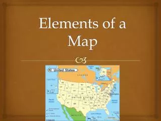
Map Elements. Write On. Latitude and Longitude. The earth is divided into lots of lines called latitude and longitude. Lines. Latitude – Equator and the parallel lines; they move up/down or north/south Longitude – Prime Meridian and the parallel lines; move left/right or east/west

E N D
Map Elements Write On
Latitude and Longitude • The earth is divided into lots of lines called latitude and longitude.
Lines • Latitude – Equator and the parallel lines; they move up/down or north/south • Longitude – Prime Meridian and the parallel lines; move left/right or east/west • The lines measure distances in degrees. Latitude Longitude
Where is 0 degree? • The equator is 0 degree latitude. • It is an imaginary belt that runs halfway point between the North Pole and the South Pole. Equator
P R I M E M E R I D I A N Where is 0 degree? • The prime meridian is 0 degrees longitude. This imaginary line runs through the United Kingdom, France, Spain, western Africa, and Antarctica.
Practice: Using the atlas pages 106-115: • 6 degrees North, 0 degrees East • 1 degree North, 32 degrees East • 30 degrees South, 28 degrees East • 35 degrees North, 5 degrees West • 15 degrees South, 8 degrees West
Answers • Lake Volta • Kampala, Uganda • Lesotho • Tangier, Morocco • Atlantic Ocean (St Helena)
Map Practice Sites to Check Out • Kidsgeo.com • Skillbuilder • Sheppard’s Site • GeoSpy
Compass Rose • There are four major or cardinal directions on a compass- north, south, east & west • Direction Quiz Source: http://aerocompass.larc.nasa.gov
Scale • Maps are made to scale - a direct connection between a unit of measurement on the map and the actual distance. • For example, each inch on the map represents one mile on Earth. So, a map of a town would show a mile-long strip of fast food joints and auto dealers in one inch.
Time Zones • The Earth is divided into 24 time zones, corresponding to 24 hours in a day. • As the earth rotates, the sun shines in different areas, moving from east to west during the course of a day. • Places that have the same longitude will be in the same time zone. Every 15 degrees equals 1 hour.
Religions Legend Map Legends • The legend is the key to unlocking the secrets of a map. Objects or colors in the legend represent something on the map.
Legend Age Expectancy
Make Our Own Map • What did humans do before satellite imaging, extended exploration… • The use of our MENTAL MAP came in handy • Your task: Create a map using the resources outside, markers, string, etc. Must haves: compass rose, legend/key, scale, cartographer, title (identifying purpose)
Citation Page for Powerpoint • Atlas - World (Holt, Rinehart and Winston) • Outline Map of US • Map Packet Download • Maps.com • National Geographic Xpeditions • Maps & Globes