Download
1 / 24
240 likes | 397 Views
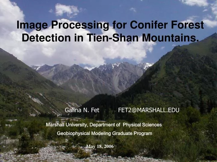
Image Processing for Conifer Forest Detection in Tien-Shan Mountains. Galina N. Fet FET2@MARSHALL.EDU. Marshall University, Department of Physical Sciences Geobiophysical Modeling Graduate Program. May 18, 2006. TIEN-SHAN MOUNTAINS, KYRGYZ REPUBLIC.

E N D
Image Processing for Conifer Forest Detection in Tien-Shan Mountains. Galina N. Fet FET2@MARSHALL.EDU Marshall University, Department of Physical Sciences Geobiophysical Modeling Graduate Program May 18, 2006
TIEN-SHAN MOUNTAINS, KYRGYZ REPUBLIC Environmental MonitoringNatural Resources Exploration and ConservationInternational Tourism Development STUDY AREA Google Earth
STUDY OBJECTIVES • imagery classification: vegetation and non-vegetation feature extraction • vegetation classification and mapping using ground data and imagery • species database compilation for Internet distribution
VEGETATION COMPLEXITY • Juniper or Spruce clear stands or mix FOREST => THAN 75 % • Dwarf Juniper and shrubs • Riparian mountain forests with Spruce • Grasslands and mountain meadows with Juniper or dwarf Juniper
STEPS AND COPONENTS INCREASE QUALITY AND ACCURACY GROUND CONTROL POINTS DATA AND SPECIES GEODATABASE PRODUCE ELEVATION LAYER EXTRACT ELEVATION CONTOURS AND WATERSHEDS FOREST TYPE DIGITAL ELEVATION MODEL BAND COMBINATION ASESSMENT AND STATISTICS SATELLITE IMAGERY AND ROCESSING SOFTWARE IMAGE PROCESSING AND CLASSIFICATION PLANT ECOLOGY AND BOTANY 3D VISUALIZATION SPATIAL STATISTICS AND SURFACE ANALYSIS
SPRUCE AND JUNIPER FOREST AT HIGH ALTITUDE ELEVATIONS 2700 m 2000 m
RIPARIAN FORESTS: SPRUCE AND JUNIPER BIRCH AND SPRUCE ELEVATION 2000 M
EXTRACTING VEGETATION ASTER BANDS 2,3
BAND COMBINATIONS ASTER LANDSAT7 ETM+ Bands 7,4,1,8 Bands 3,2,1,8 R CLAY 5/7 G OXIDE 3/2 B VEGETATION 4/3
GEOLOGICAL PROCESS ASTER IMAGERY RGB SWIR6, NIR3, VNIR1 ICE CAPS - DARK BLUE ROCKS AND SHALE - YELLOW
TRAINING AREA BANDS 531 5,4,2 ASTER ASTER NIR, VNIR AND THERMAL BANDS 4,3,13
TRAINING AREA ASTER BROVEY TRANSFORM R 4/431, G 3/431, B 1/431
SUPERVISED CLASSIFICATION DIGITIZING CONTOURS SPECTRAL SIGNATURES
SUPERVISED CLASSIFICATION SPRUCE FOREST mixed with two different species of junupers (Juniperus turkestanica – dwarf juniperand Juniperus semiglobosa), SPRUCE-BIRCH forest with shrubs and other deciduous trees in the understory. DWARF JUNIFER SHRUBLIKE FOREST in association with numerous and diverse shrubs in the understory
SHUTTLE RADAR TOPGRAPHY MISSION DATA(SRTM30) 30 M RESOLUTION OVER US 90 WORLD 16 M VERTICAL AND 20 M HORIZONTAL ACCURACY FREE FTP DONLOAD
DIGITAL ELEVATION CONTOURS SRTM CONTOURS (RED) TOPO MAP CONTOURS (BLACK)
VEGETATION CLASSIFICATION LAYER DRAPED OVER BAND LS543 COMBINATION
RESULTS USED SATELLITE IMAGE CLASSIFICATION AS A MAP BASE FOR CONIFER FOREST GEODATABASE LANDSAT7 ETM+, ASTER, SRTM MAPPED THE RESULTS OF BIOTIC SURVEY USSING MODERN GEOREFERENCING TECHNIQUES DEMOSTRATED IMAGE PROCESSING TECHNIQUES AND CAPABILITIES TO RECOGNIZE LAND USE FEATURES WITH ARCGIS/ARCINFO SPATIAL ANALYST, 3D ANALYST
The author is grateful to the American Association for Advancement of Sciences providing opportunity for research initiation through a travel grant. Photographs by the author, SMAK and Celestial Mountains Co.