Download
1 / 42
1.01k likes | 2.73k Views
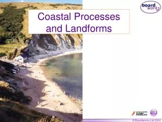
Coastal Landforms. Erosional and depositional landforms. Defining the Coastal Area / Zone. The coastline is the line where the land and sea meet.

E N D
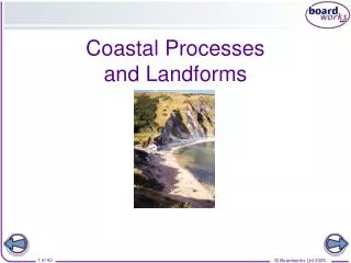
Coastal Landforms Erosional and depositional landforms
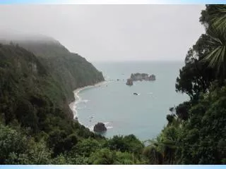
Defining the Coastal Area / Zone • The coastline is the line where the land and sea meet. • The coast is a zone or strip of land extending from the coastline, which borders the sea to where the land rises inland. Its limit is marked by the level of high tide. • The shore is the zone which lies between mean high low water mark and high water mark and constitutes both the backshore and foreshore. • Backshore is the zone between mean high tide level and the coastline. • Foreshore is the lower zone of the beach lying between the low and high water level.
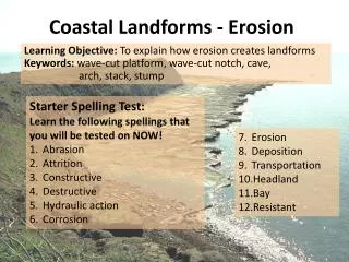
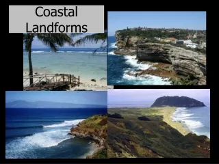
Cliffs Headlands and bays Waves, arches and stacks Wave-cut platforms Blow Holes or Gloups and Goes Features Produced by Wave or Marine Erosion
Cliffs Most fundamental and ubiquitous feature of rock coastlines. Variations based on differences in • Lithology • Jointing • Structure • Degree of exposure • Erosional History • The dip of the rock • Wave action • Sub-aerial erosion
Dead or a(Live) • Classification into Live or Active cliffs, those which are experiencing wave erosion , or experiencing sub aerial activity, gullying, soil creep or slumping. They often have free-faces • Dead cliffs are isolated from the sea by sand, shingle, sand-marsh deposits, and rock marsh
Cliff Development • Removal of a wedge-shaped mass of rock, ( a notch) largely by the mechanical action of breaking waves, often utilizing some weakness • Once this has been initiated, basal attack, weathering and slumping, gullying and mass-movement wear down the headland • The cliff increases in height and the wave-cut platform is extended
Cliff Development • 4 As the wave cut platform develops, the process slows down as the shallower water over the platform slows down, and the basal attack is less intense.
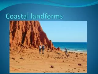
Headland and Bays • Where there are alternating beds of hard and soft rocks, the hard rocks offer a greater resistant to erosion . They eventually stands out as headlands, that is, as promontories with steep cliff sides projecting out into sea. • The softer rocks are easily eroded as they are less resistant to marine erosion. In due course an indentation or cure in the land, called a bay is formed. Bays are separated by headlands.
Processes • Several other processes are found in and on cliffs, these include • Sub-aerial processes ( Weathering and Mass movement); e.g. slumping, sliding, soil-creep, freeze-thaw, carbonation, salt-crystallization, biological weathering
Rates of Cliff Recession • Variation based on the • Structure of the rock • The Aspect • The vegetation • Man’s impact • Protect ional features
Notches • These are grooves that are eroded into cliffs • Between mean high tide and low tide • Extremely important in cliff development • Develop in areas of weakness • Variations include smooth rounded rocks in limestone and chalk ( chemical action)
Wave Cut Platforms Tremendous variation • Some are temporary, some permanent. • Some are covered with sand and shingle, others have channels, trenches and hollows • In hard rock the platforms are poorly developed whereas in soft homogenous rock there are broad, even surfaces with minor furrows
Wave-cut platforms • Formed by wave abrasion, and solution • Delicate balance based on the resistance of the rock • Weak rock will collapse • Strong rock resistance will be minimal
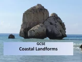
Caves, arches and stacks • Caves – a natural underground hollow formed by erosion’ • Arches – formed by the wearing away of narrow headland, generally by the formation of two back-to back caves which eventually join. These are temporary and eventually collapse • Stacks- Tall isolated pillars of rock that are free standing in the sea, alone or in a group. They may result from the collapse of an arch and are normally residual features formed from a former headland • Stumps rocky platforms offshore that may be covered at high tide, but may be uncovered throughout the day.
Geos • Long, narrow gorge-like inlets, normally formed because of the collapse of a cave
Features Produced by Marine Deposition • Beaches • Spits and Bars • Tombolos • Mudflats • Sand Dunes
Beaches • A beach is an accumulation of materials such as boulders, pebbles, shingle, sand and mud on a sloping or shelving ground. The waves which break offshore result in its erosive power decreasing . This is caused by the swash and backwash which deposits materials on the shore.
WHAT ARE SPITS? Spits are generally linear deposits of beach material attached at one end to land and free at the other. Where the direction of the coast changes, sediment carried by longshore drift may form a tongue of sand and other material, which is called a spit
Spits are formed when a large accumulation of material forms a narrow strip of land that juts out into the sea but is still connected to the mainland.Where a river carries large amounts of material into a bay, waves moving obliquely will transport the material in a diagonal direction along the beach by the process of longshore drift. An example of a spit is the Cocal spit at the mouth of the Nariva River on the east coast of Trinidad HOW ARE SPITS FORMED? .
CONDITIONS NECESSARY TO FORM A SPIT • There must be a good supply of sand and other sediments • Waves must approach the coast at an angle, so that longshore drift moves material along the coast • The sea must be relatively shallow • The sea is usually fairly calm, with low-energy constructive waves
WHAT ARE TOMBOLOS? A linear deposit of sand or stones, formed by longshore drift, which joins an island to the mainland is called a tombolo. An example of a tombolo is the Palisadoes in Jamaica
MUDFLATS • Mudflats are lowlying parts of the coast which are submerged at high tide and low tide. They are normally located behind a bar or sandpit or besides estuaries and are comprised of silt or clay. In tropical areas mudflats support dense tropical mangrove vegetation community often with large area of swamp.
SAND DUNES • Some sea shores consist of ridges of sand deposits by waves and shaped by wind. These are termed sand dunes. They are confined to coastal areas which are lowlying and are above sea high water tidal level. • The onshore winds blowing across sandy beaches constantly renew and shape the sand deposits. Vegetation on the coast trap the sand and causes it to be stationary . • Sand dunes are common in Port Royal in Jamaica and Sandy Belt in Guyana.