Download
1 / 26
260 likes | 261 Views
FGDC Standards Facilitating data accessibility, and integration. Sharon Shin FGDC Metadata Coordinator Air Force Space Command Emergency Services Symposium Colorado Springs, Colorado November 18, 2003. FGDC Standards. Standards organizations Federal guidance on standards

E N D
FGDC StandardsFacilitating data accessibility, and integration Sharon Shin FGDC Metadata Coordinator Air Force Space Command Emergency Services Symposium Colorado Springs, Colorado November 18, 2003
FGDC Standards • Standards organizations • Federal guidance on standards • Why use standards? • Recognition of non-Federally authored standards • Geospatial One-Stop
Standards Organizations • ISO, The International Standards Organization • ANSI, American National Standards Institute • INCITS • INSITS-L1 • FGDC, Federal Geographic Data Committee
Federal Standards Guidance and the FGDC • Executive Order 12906 (April 1994) • OMB Circular A-16 • OMB Circular A-119 • OMB Circular A-11 • OMB Circular A-130
Why use Standards • Facilitate data sharing • Increase interoperability among automated geospatial information systems.
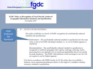
Non-Federal Standards • Standards developed by other organizations • FGDC proposed policy on endorsement or recommendation of non-Federal standards Two levels of FGDC recognition • Endorsement – mandatory for use • Recommendation – the non-federal standard is recognized as a useful standard, but is not deemed to be of such broad applicability that its use should be mandatory.
Geospatial One-Stop • Accelerates implementation of the NSDI, making geospatial information access easier, faster, and cheaper for all levels of government and public • Increases federal agency accountability for the stewardship and sharing of geospatial resources. • Intergovernmental Board of Directors provides guidance to the project; includes Federal and non-federal.
Geospatial One-StopProject Modules • Establish integrated Data Content Standards for commonly used data themes. • Use metadata to inventory, document and publish Framework data holdings in NSDI Clearinghouse. • Publish metadata for planned data acquisition and update for Framework data in NSDI Clearinghouse (geospatial data marketplace). • Prototype and deploy enhanced data access and web mapping services for Federal Framework data. • Establish a Federal Portal (One-Stop) as a logical extension to the NSDI Clearinghouse Network.
Relationship of Framework Standards Rail Air Roads Elevation Transportation Transit Base Standard Waterways Cadastral Geodetic Control Governmental Units Orthoimagery Hydrography
Standards submitted to ANSI through Geospatial One-Stop Modules 1, 2, 3, 4, 5 Final draft pre-ANSI harmonized framework data standard Module 1 Working draft base standard Base Standard Elevation Cadastral Hydrography Working draft framework data standard (scheduled for September 30) Working draft data theme standard Gov. Units Orthoimagery Geodetic Control Transportation Working draft sub-theme standards Air Rail Roads Transit Waterways
Discussion In your experiences as first responders consider how the following would impact your ability to act. • Locating data • Readily accessible data
FGDC Standards • The National Grid/The Soil Geographic Data Standard • Accuracy Standards • Spatial Data Transfer Standards • Classification Standards • Content Standards
FGDC Standards • The National Grid • The Soil Geographic Data Standard
Accuracy Standards • National Map Accuracy Standards • Geospatial Positioning Accuracy Standard • Reporting Methodology • Geodetic Control Networks • National Standard for Spatial Data Accuracy • Architecture Engineering Construction and Facilities Management
Spatial Data Transfer Standard • SDTS, modified adopted by ANSI • Part 5- Raster Profile and Extensions • Part 6- Point Profile Status: Currently undergoing a five-year periodic review through INCITS. http://mcmcweb.er.usgs.gov/sdts/
Classification Standards • Classification of Wetlands and Deepwater Habitats of the United States • Vegetation Classification Standard
Content Standards • Cadastral Data Content Standard • Content Standard for Digital Orthoimagery • Content Standard for Remote Sensing Swath Data • Utilities Data Content Standard • Content Standard for Digital Geospatial Metadata
Discussion In your experiences as first responders consider how the following would impact your ability to act. • Varying levels of content • Varying classification systems
Metadata • The value of metadata • Data preservation • Extending project dollar/efficient use of funds • Data access
Content Standard for Digital Geospatial Metadata • Biological Data Profile • Metadata Profile for Shoreline Data • Extension for Remote Sensing Metadata
Who What Where Why When How Sources Methods Processes Attributes Projection Distribution Minimal vs. Detailed Metadata
Discussion In your experiences as first responders consider how the following would impact your ability to act. • Varying scales • Attributes lack of/varying • Temporal aspects • Other data issues
Metadata in the Future • ISO • Why a new standard • When • Migrating to the new standard
Accessing Metadata Clearinghouse GOS Portal www.fgdc.gov/clearinghouse www.geodata.gov/
Metadata to make your datasets accessible/useable by the GOS portal • Metadata • Projection information • Unique identifier • WMS “get”, “post” request