Download
1 / 18
180 likes | 278 Views
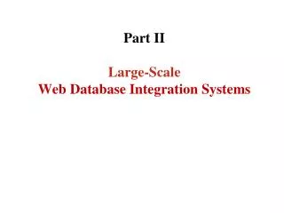
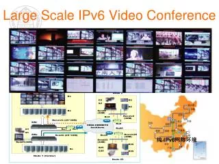
Chris Cummings. Retrieving Large-Scale High Density Video Target Tracks from Spatial Database. What’s it all about. Traffic cameras recording targets and retrieving them

E N D
Chris Cummings Retrieving Large-Scale High Density Video Target Tracksfrom Spatial Database
What’s it all about • Traffic cameras recording targets and retrieving them • Cameras track targets and the data needs to be recorded, but how are you supposed to store physical data, let alone go through it?
What is Spatial Database • Mapping and querying something of objects defined in geometric space. • Normally handle a point, line, or polygon. • 3D objects can also be represented (this case)
Target tracking data • Sensors are running. • Video-analytic software extract target tracks from the video in real time. • Geometric rules are drawn on maps by using the geo-browser* to retrieve targets. • SQL query is submitted to the spatial database. • Spatial calculations are done and the tracks of targets are received.
Image from above • Frames are recorded and saved as image sequences in JPEG format with roughly 3 frames per second
Spatial inedxing • Spatial database divides space into subspace then indexes each of the subspaces. • The MS SQL server divides the space to 4 levels of grids. • These levels are divided to 3 grid densities. • Objects are then associated to cells which are touched as it traverses the grid levels. • These cells become the points for the spatial database to be indexed.
Searching for Space • Querying space is used to search area with geometric shapes that when combined make up the entire search space perfectly. • Cells that are touched by objects are compared to past cells and adjacent cells.
Spatial Grid layout • Grids can be broken down to degrees of detail. • They are calculated by dividing the site size with grid densities • High = small area in meters but finer detail. • Lower = larger area with less detail. • Greater detail not always best. • Takes up a lot of space • Takes a lot of computing time to go through the indexes • 6.6 x 6 centimeters accuracy. Not tracked to centimeters so is a waste. • Configuration of a grid can be set to HHHH, LLLL, and everything in between. • Configuration is based on the situation of the enviorment
Performance • HHHH is 8.4 times as large as LLLL due to tracking cells. • To reduce the size of the index, reduce the size of the data. • Tracklets are the points of data. • For every 1,000,000 tracklets insertion time is measured as they are put into the database. • To insert 1,000,000 tracklets it takes 1227 seconds. If the data is bigger, this can take even longer.
Insert from multiple sensors • Simulations were done using 12 and 18 sensors, putting in data. • Highest insertion capacity if inserted in batch. • Many sensors putting in 100 targets per insertion gave the best results.
Tripwire • Used like a regular trip wire would be. • The tripwire is defined as a point on all of the camera sensors. • When the point is crossed an alarm is raised and all the tracklets are found by finding all which intersect the tripwire area.
Area of Interest (AOI) • Regions defined by users • These regions can be monitored and watched. • With this, only the specific area you want will be tracked which can save on time and space. • Removes unnecessary points. • BUT what if those points could be used and is overlooked?
Cache(ing it all in) • Cache saves time. • Cache is used to save time so the disk does not have to be read. • Can get information from disk • Ran from start • Can get information from cache • Ran a second time • Much faster • In running time, SQL sever can read from cache and disk so it is very good at performance. • AOI does better then Tripwire because of index sizes. • Tripwire is larger.
Data Types (Points VS Lines) • Which do you think takes up more space? • This . (point) • Or -------- (line) • You guessed it! The line! • Because of this, when available points are used and saved instead of lines.
Multiple properties • There are other properties that are used for targets that can be combined to make a search fast. • Speed, Size, Classification, Color • Obviously searching for coupled things would result in a faster search. • Speed + Size > Speed • Filter breaks down spatial objects, then the properties are taken into account. This trims down on the search time.
Table breakdowns • Tables need to be broken down for easy access. If they were not, then it would take much longer to access all the data. • Table partitions allow for transactions to be searched in specific areas instead of the whole database. • EX time is 30 days which is broken into 3 10 days with all the attributes of time. This makes for a faster search. • The user sees none of this and it is all still 1 table
Database all over • The database isn’t 1 central location. • Portioned tables are scattered all over. • A computer may hold a small area and another may hold more. • This may not make sense to a small region but if this system is for a city, this is a good concept.
Finished • Questions?