Download
1 / 22
220 likes | 368 Views
Community Services for Serving LiDAR Data. Christopher J. Crosby, J Ram ó n Arrowsmith, Jeffrey Connor, Gilead Wurman Efrat Frank, Ashraf Memon, Vishu Nandigam, Chaitan Baru International Workshop of Cyberinfrastructure for Geosciences (IWCG2006).

E N D
Community Services for Serving LiDAR Data Christopher J. Crosby, J Ramón Arrowsmith, Jeffrey Connor, Gilead Wurman Efrat Frank, Ashraf Memon, Vishu Nandigam, Chaitan Baru International Workshop of Cyberinfrastructure for Geosciences (IWCG2006)
LiDAR (LIght Detection And Ranging) a.k.a ALSM (Airborne Laser Swath Mapping) • Airborne pulsed laser scanning system + differential GPS + inertial measurement unit (IMU) • > 30,000 points/second • Ground sampled multiple points/sq. meter • ~ 15 cm vertical accuracy • ~$300 - $500 per sq. km acquisition cost http://coastal.er.usgs.gov/hurricanes/mappingchange/
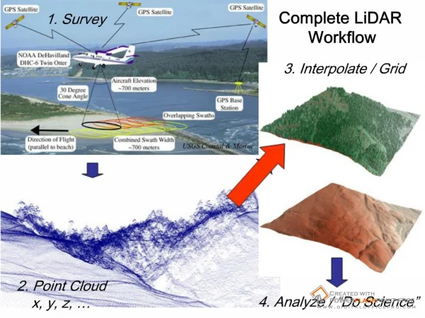
Complete LiDAR Workflow Survey Interpolate / Grid D. Harding, NASA Point Cloud x, y, z, … Analyze / “Do Science”
Triangular Interpolation Network (TIN) Inverse Distance Weighted (IDW) Kriging Regularized Spline with Tension and smoothing (RST) Figure from Helena Mitasova (NCSU): http://skagit.meas.ncsu.edu/~helena/gmslab/index.html
Project goal: Democratize access to LiDAR point cloud data using cyberinfrastructure available through the GEON project.
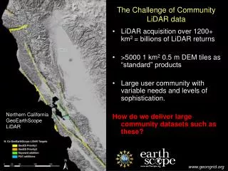
Example Data Set: • Northern San Andreas fault and associated marine terraces. • Flown February 2003 • Funded by NASA in collaboration w/ USGS. • ~418 Square Miles ~1.2 billion data points
The Computational Challenge: • LiDAR/ALSM generates massive data volumes - billions of returns are common. • Distribution of these volumes of point cloud data to users via the internet represents a significant challenge. • Processing and analysis of these data requires significant computing resources not available to most geoscientists. • Interpolation of these data challenges typical GIS / interpolation software. • our tests indicate that ArcGIS, Matlab and similar software packages struggle to interpolate even a small portion of these data.
Multi-institution collaboration between IT and Earth Science researchers • Funded by NSF “large” ITR program • GEON Cyberinfrastructure provides: • Authenticated access to data and Web services • Registration of data sets and tools, with metadata • Search for data, tools, and services, using ontologies • “GEON was designed as an equal collaboration between Information Technology (IT) and Geoscience researchers, with the goal of developing an enabling IT platform to facilitate the next generation of Geoscience research.” • Scientific workflow environment • Data and map integration capability • - Visualization and GIS mapping Distributed Network GEON / ASU node “Agassiz”:
The Vision: Conceptual GEON LiDAR Workflow • Utilize the cyberinfrastructure developed by GEON to offer online data distribution, interpolation to grid, and analysis of large LiDAR datasets. • Completely internet-based workflow: • Point cloud to visualization • Utilize modular web services to complete a variety of processing and analysis tasks. • Offer users control of interpolation and analysis parameters.
Goal = interactive processing environment for iteration and exploration of various interpolation and processing options. • Optimize landscape representation based upon application of the data. • By using distributed computing resources, user is able to quickly run multiple jobs and compare results. • Similar iteration may take days or weeks on a single local machine. • Leave computationally intensive data processing to resources available through GEON and offer user downloadable products in common file formats.
Products: Hillshade of DEM Slope Map Aspect Map Profile Curvature Map
Implementation Overview: The GLW utilizes advanced spatial databases (IBM DB2), GRASS Open Source GIS, Kepler Workflow manager and web service technology to distribute, interpolate, and analyze LiDAR data. GRASS GIS
Current GLW Status Datasets online: • Northern San Andreas Fault • West Rainier Seismic Zone • Eastern California Shear Zone 4. Dragon’s Back portion of the San Andreas Fault (B4 Project) Total of ~2.6 billion LiDAR returns available via GLW. Mike Oskin PI
Future Work Development of GLW is an ongoing project • Additional datasets • Point cloud reprojection • Additional interpolation algorithms: • Moving window: Block min / mean / max • Improve DEM generation performance • Additional tools and functionality
Future Work • GLW as a tool for data integration • Co-hosted raster imagery: • Aerial photography • Hyperspectral • Incorporation of terrestrial LiDAR data (TLS) • Dynamically generated 3D objects for web-based visualization: • VRML • Fledermaus scene (.sd) files
LiDAR data integration: Dynamically generated 3D model from LiDAR DEM and aerial photography
GLW as a community resource • Currently, LiDAR datasets are hosted and maintained by a variety of organizations/agencies. • Goal is to provide a unified “one stop shop” portal for users to access and process these datasets. • GLW architecture is modular and scaleable so it is well suited to managing access to geographically distributed datasets and processing tools. • Discussions underway with a number of organizations/agencies to expose their data via the GLW: • U.S. Geological Survey EROS Data Center • Forthcoming UNAVCO/GeoEarthscope datasets
GEON LiDAR Workflow Access Instructions: http://www.geongrid.org/science/lidar.html More information on the GLW: Efrat Jaeger-Frank, Christopher J. Crosby, Ashraf Memon, Viswanath Nandigam, J. Ramon Arrowsmith, Jeffery Conner, Ilkay Altintas, Chaitan Baru, A Three Tier Architecture for LiDAR Interpolation and Analysis, Lecture Notes in Computer Science, Volume 3993, Apr 2006, Pages 920-927, DOI: 10.1007/11758532_123. Crosby, C.J. et al., A geoinformatics approach to LiDAR data distribution and processing for the earth sciences, in preparation. Abstracts, posters & powerpoints: http://lidar.asu.edu/