Download
1 / 61
620 likes | 915 Views
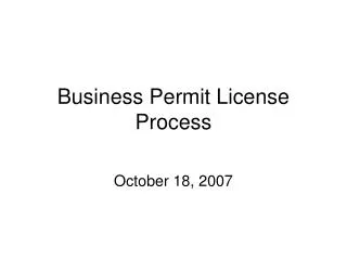
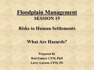
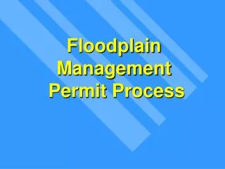
Floodplain Management Permit Process. Floodplain Permit Process. In 100-Yr (1% Chance) Floodplain?. a. Document how determined. b. Continue permit process. NO. Determine if site is in FW or FF; Calculate the 1% chance flood elevation & FW/ FF boundary

E N D
Floodplain Permit Process In 100-Yr (1% Chance) Floodplain? a. Document how determined. b. Continue permit process. NO Determine if site is in FW or FF; Calculate the 1% chance flood elevation & FW/ FF boundary Registered P.E. must do study If Floodway – Go to FW process If Flood Fringe – Go to FF process YES GFP (“A Zone”) Determine if: 1. General Floodplain (GFP) 2. Flood Fringe (FF), or 3. Floodway (FW) FF FW • FLOODWAY PERMITTED USES • --------------------------------------------------------------- • Document permitted use standards met: • Low damage potential • Associated with permanent open space use • Does not obstruct flows (0.01 foot standard)e • No permanent structures • FLOOD FRINGE PERMITTED USES • --------------------------------------------------- • Document permitted use standards met: • Flood Protection Elevation (FPE) • Fill elevation w/in 15’ of structure • Dryland access Deny permit NO NO Meets Stds? Meets Stds? YES YES FOLLOW 12-STEP PROCESS • Issue permit • Inspect
12-Step Permit Process • Applicant submits project description • Determine project location • Determine flood zone at site • Determine applicable standards • Can the project meet the standards? • Check for substantial improvement
12-Step Permit Process • Check for other required permits • Verify structure’s proposed lowest floor elevation (LFE) • Issue permit (include E.C. in file) • Verify LFE after 1st pour • Verify as-built LFE • Issue Certificate of Occupancy
Elevation Certificate Form Download from: • www.fema.gov/nfip/elvinst.htm NFIP Surveyor Training: • http://training.nfipstat.com/ecsurveyor/ Information for Local Officials: • http://www.fema.gov/business/nfip/infosl.shtm
NFIP ELEVATION / FLOODPROOFING CERTIFICATES • Serve as record of lowest floor elevation • Necessary to obtain actuarial insurance rating • CRS credit
DIAGRAM 1 All slab-on-grade single- and multiple-floor buildings (other than split-level) and high-rise buildings, either detached or row type (e.g., townhouses); with or without attached garage. Distinguishing Feature – The bottom floor is at or above ground level (grade) on at least one side. * b NEXT HIGHER FLOOR a BOTTOM FLOOR GRADE g f (determined by existing grade)
NEXT HIGHER FLOOR b BOTTOM FLOOR a RFPE GRADE g f (determined by existing grade) Elevation Certificate – Diagram 1 • “Lowest Floor” for Insurance Purposes • “Lowest Floor” = lowest habitable floor
Next Higher Floor Basement Grade Basement Below Grade on All Sides
If Residential a b NEXT HIGHER FLOOR GRADE BOTTOM FLOOR (BASEMENT) g f (determined by existing grade) Elevation Certificate – Diagram 2 Basement
a HIGHER FLOORS NEXT HIGHER FLOOR b RFPE BOTTOM FLOOR g f (determined by existing grade) GRADE Elevation Certificate – Diagram 3 • Basement • Lowest Floor
ALTERNATIVE ELEVATING METHODS • Only apply to N/C structures • Examples: • Pilings/Piers • Basements with openings • Internally flooded crawl spaces
OPENINGS* b NEXT HIGHER FLOOR a g WALKOUT LEVEL f Elevation Certificate – Diagram 7 • Basement • Enclosure below Lowest Floor
Enclosure That Portion of an Elevated Building Below the Lowest Elevated Floor that is Either Partially or Fully Shut-in by Rigid Walls.
Bayport Condos DRY FLOODED
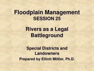
b NEXT HIGHER FLOOR g a f OPENINGS** CRAWL SPACE Elevation Certificate – Diagram 8
Internally Flooded Crawl Space **Note: Crawl space can be used for limited storage, parking of vehicles and building access only. Main Level RFPE Grade top of main level floor is lowest floor level • Crawl space not a basement (not sub-grade on all sides) • Top of floor of crawl space not lowest floor since it is properly internally flooded.**
Criteria for Elevation on Perimeter Wall Foundations • All A Zones, with low-velocity flooding (less than 5 feet per second) • The inside grade of the crawlspace floor must match the outside grade on at least one side of the building. • Designed to automatically equalize hydrostatic flood forces on exterior walls by allowing for the entry and exit of floodwaters
Minimum Standards for Foundation Openings • A minimum of two openings having a total net area of not less than one square inch for every square foot of enclosed area subject to flooding. • The bottom of all openings shall be no higher than one foot above grade. • Openings may be equipped with screens, louvers, valves, or other “automatic” coverings
Caveats for Enclosed Areas Under Lowest Floors • Additional flood insurance rating requirements so the enclosed area is not considered a basement: • the automatic openings are on at least 2 sides of the structure, and • The enclosed space cannot be finished (no finished wall-paneling, flooring, etc.) (source: Flood Insurance Manual, Page LFG 1)
1 foot Crawl Space Foundation with Openings Lowest Floor Opening (typical)
Walkout Lower Level Not at RFPEWith Internal Flooding** Grade Garage Grade Lower Level RFPE top of lower level floor is lowest level **Internal Flooding Meets TB 1-93 and space used only for storage, access and vehicle storage
(Not Permitted) Upper Level Grade Grade Garage RFPE Lower Level top of lower level floor is lowest level Note: NO Internal Flooding Walkout Lower Level Not at RFPE
(Not Permitted) Grade Grade Main Level Garage RFPE Basement top of basement floor is lowest floor level Basement Example
(Not Permitted) Grade Garage Grade Main Level RFPE Crawl Space Crawl Space Example top of crawl space floor is lowest floor level This crawl space IS considered a basement (since it is sub-grade on all sides). It is NOT ALLOWED.
Is this a Basement? RFPE
Lowest Floor ElevationsBasement Foundation Lowest Floor Basement Lowest Floor
Walkout Lower Level AT RFPE Upper Level Grade Garage Lower Level RFPE top of lower level floor is lowest floor level
NO YES GFP “A Zone” FW FF Floodplain Permit Process • Document how determined. • Continue normal permit process. In 1% Chance Floodplain? Floodway (FW), Flood Fringe (FF) or General Floodplain (GFP) Determine if FW or FF & BFE ------------------- Detailed (PE)
NO YES Determine & Document: a. RFPE b. Fill elevation w/in 15’ c. Dryland access FF Permit Process Go to Variance Process Permitted Use (elevated on fill)?
Flood Fringe BasicsStandards for Permitted Structures • Top of lowest floor, including basement, at FPE • Fill at RFE plus one foot • Fill extends 15 feet from structure • Access road at or above RFE
State Minimums for Structures in Flood Fringe Areas 100-year flood elevation (RFE) Not to Scale Top of Floor at FPE* > 15' > 15' >1’ *FPE = 100-year flood (RFE) + 2' (minimum)
Standards for Elevation on Fill... • Fill should extend a minimum of 15 feet beyond all sides of the structure • Erosion protection is required for high velocities / steep slopes
Standards for Elevation on Fill • Fill should be placed in maximum 12-inch lifts, and compacted to 95% of the maximum density obtainable with the Standard Proctor Test Method • Fill slopes should be no steeper than 1.0-foot vertical to 1.5-feet horizontal
*Calculation of Regulatory FloodProtection Elevation (RFPE)* • Regional Flood (100-yr.) Elevation: = 1091.0 • Freeboard Fill Req’d by ordinance = 1.0 • FPE: = 1.0(add above) = 1093.0
Structure’s Elevation Requirements In:[ ] N.G.V.D. [ ] Assumed Datum [ ] In relation to street • proposed required • Basement or lowest floor = ________ - __________ • First Floor (above grade): = ________ - __________ • Max. Building height: = _______ - ________ • Fill Elev. Adjacent to Structure: = ________ - ________ x 1091 1093 1092
Required By Actual Ordinance As-Built 2. Structure: a. Elevation of first floor: =_________ - _______ b. Basement elevations: =_________ - _______ b. Lowest adjacent grade: =_________ - _______ c. Highest adjacent grade: =_________ - _______ 3. Sewer: a. Top of septic or holding tank: =_________ - _______ b. Bottom of drainfield trench or bed: =_________ - _______ 4. Low point of access/road: =_________ - _______ 5. Compacted fill elevation around building: =_________ - _______ 6. Top of well casing: =_________ - _______ 7. Elevation to which structure is flood proofed: =_________ - _______ 1093 (no basement) 1092 NA NA 1091 1092 NA 1093
Is this really 1 foot ….or less? Picture ?