Download
1 / 39
430 likes | 1.06k Views
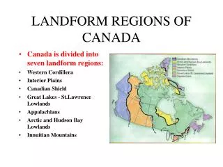
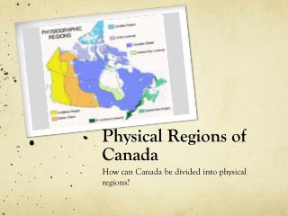
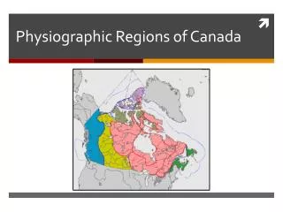
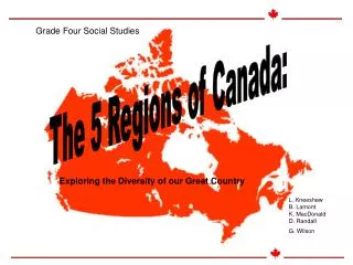
Land Form Regions of Canada. Landform Regions. Precambrian Shield Great Plains Western Cordillera Great Lakes / St. Lawrence Lowlands Appalachians Northern Mountains & Lowlands Hudson Bay Lowlands. Precambrian Shield. Covers almost half of Canada.

E N D
Landform Regions • Precambrian Shield • Great Plains • Western Cordillera • Great Lakes / St. Lawrence Lowlands • Appalachians • Northern Mountains & Lowlands • Hudson Bay Lowlands
Precambrian Shield • Covers almost half of Canada
Precambrian means that it was formed before the Cambrian Period (600 million years ago).
It is geologically complex - it has seen cycles of mountain building and erosion, repeated faulting, folding and volcanism. • Today the area has been reduced to a peneplain (almost a plain). Elevations seldom exceed 600m.
The Canadian Shield is known as “Canada’s Mineral Storehouse”. • It is rich in gold, copper, nickel, lead, zinc, iron & other metals.
Great Plains • The plains were formed after the Precambrian shield
Shallow seas, full of hard-shelled sea life, invaded North America during the early eras. • The shells formed thick strata of limestone & chalk.
Material from both the Shield and later the Western Cordillera eroded, adding to the rock layers of the plains.
The plains are not completely flat. They are divided into Three Prairie Levels. The Manitoba Escarpment separates the 1st and 2nd Prairie Levels. The 3rd Prairie Level was protected by a tough cap rock.
The Missouri Coteau Escarpment is less distinct - like a row of hills.
Other relief features: • deep valleys cut by rivers • scattered moraines (glacial features) from the last ice age. • Aridbadlands of Alberta • Foothills at the Cordillera edge • Cyprus Hills across the Alberta - Saskatchewan border.
Oil & gas have collected in the porous sedimentary rocks. • Rich soils developed as a result of glacial deposits.
Western Cordillera • The highest & most rugged landscape of Canada. • The mountains formed when the Pacific Plate was subducted under the North American Plate about 65 million years ago.
Cross Section of the Western Cordillera Coastal Mountains InteriorPlateau Eastern Mountains Mainland or Coastal Mountains Rocky Mountains Columbian Mountains VancouverIsland Pacific Ocean Strait of Georgia Fraser River Valley Rocky Mountain Trench
British Columbia consists of a large interior plateau in between two mountain ranges. • Both ranges are further divided by deep trenches. • The Interior Plateau resembles areas of high hills or low mountains. • Glaciers & rivers have cut deep into the land leaving deposits great for farming.
The Eastern Mountains • The Rocky Mountain Trench divides the Eastern Mountains into the Rockies (east) & the Columbian Mountains (west). • Formed mostly of folded sedimentary rock, some of which are rich in fossils. • The Columbian Mountains are older and more faulted / metamorphosed • The highest peak is Mount Robson at 3954m.
The Coastal Mountains • Also split in two by a trench (filled by the Strait of Georgia) • On the west are the off shore islands & on the east are the mainland mountains along the coast. • The highest peak in Mount Logan (Yukon) at 5951m.
Great Lakes & St. Lawrence Lowlands • The landscape is very favorable for agriculture & settlement.
The area was submerged by inland seas. • Sediments were deposited on it from the shield & the Appalachians. • When the seas drained away they left a varied strata of limestones, sandstones and shales.
The Niagara Escarpment was formed when the soft material was eroded north and east of the tough Lockport Dolomite.
Niagara Escarpment Grimsby, Ontario
The Niagara River flows over the cap rock forming the famous Niagara Falls.
Glacial ice scoured deepened the Great Lakes. • Melt waters at the end of the last ice age caused the lakes to overflow.
As the ice melted and the area became covered by a ground moraine - a postglacial blanket of material.
The Saint Lawrence Lowlands has a different top layer of sediment. • As the ice melted the water rushed inland forming the Champlain Sea. • Over time the land rebounded forcing the water off & leaving marine deposits and rich soils.
Appalachians • The St. Lawrence Lowlands & the Appalachian Mountains are separated by a fault line called Logan’s Line.
Appalachians are the remains of an ancient mountain chain. • Formed by the collision of the North American Plate & Eurasian Plate 200 million years ago. • After the collision volcanoes erupted, magma intruded and faults occurred.
Millions of years of erosion has greatly changed the original mountain formation.
The last ice age scoured the landscape, formed glacial valleys & deposited glacial moraines.
Northern Mountains & Lowlands • The Northern Mountains of the Arctic Archipelago Islands formed mostly from folding & faulting processes.
Hudson Bay Lowlands • The shield is shaped like a saucer. The numerous lakes & rivers tend to drain toward the Hudson Bay.
The lowlands are divided into two areas - the Hudson Bay lowlands and the Southern Islands of the Arctic Archipelago.