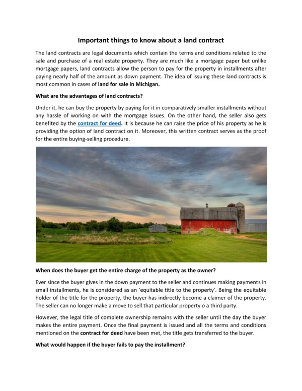
Download

1 / 4
0 likes | 4 Views
Do you know about land surveys and their essentials? A land survey measures and maps a specific area's boundaries, contours, and features. It uses advanced instruments to determine property lines, elevations, and spatial relationships. This process is crucial for land development, legal purposes, and accurate land ownership records. A land survey is vital for precise property boundaries, preventing disputes, and ensuring responsible growth. It safeguards investments and promotes sustainable land use.<br>To know more: https://aaagrouponline.com/what-is-land-surveying-and-why-is-it-important/

E N D
WHATISLANDSURVEYINGANDWHYISIT IMPORTANT? Are you a new developer looking to develop a plot of land? Are you dealing with plots of land owned by others? If so, a land survey will be a useful asset. A land survey establishes boundaries on a piece of land. It helps developers know the proper borders to prevent building on a neighbor’s land. Moreover, a survey will determine if a developer can develop the land effectively. A survey also ensures that construction crews adhere to building codes and zoning mandates.
In many cases, developers hire land surveyors before buying a piece of land. In other cases, owners may want to split the land for further development. This article will reveal more about land surveys. Let’s explore. HowtoSurveyLand Land surveying requires three key items: a level, a tripod, and a theodolite. A level can be a sight level or a laser level. A theodolite is a telescope used to calculate the vertical and horizontal angles between various points. You’ll see this type of telescope installed on the tripods. HowtoFindaQualityLandSurveyCompany You can find a surveyor in the following places: ● Survey Comparison Websites: A comparison website allows you to compare multiple surveyors. As a result, you can find the best match for you. ● Local Companies: You may find a trustworthy local survey company. Also, choose smaller surveyor companies instead of larger ones. High-level surveyors may not be fully attentive to your land. A quality survey requires extensive time and preparation. Busy surveyors may miss something crucial, resulting in sub-par work.
More importantly, pick an objective surveyor who has no affiliation with your land deal. An independent company will produce an unbiased survey that all parties can agree to. FindingtheRightSurveyor Before hiring a land surveyor, read various reviews online. Are they trustworthy? Are their land surveys accurate? Read what previous customers said about the company. Choose the company that has the most five-star ratings. Avoid companies with low or mediocre ratings. Plus, choose a surveyor with experience. Additionally, ask questions about their land surveying experience. Experienced professionals may also offer specialized services. TypesofLandSurveys Overall, there are three types of land surveying services: ● Construction ● Boundary/Land ● Geodetic An engineering survey involves such attributes as construction, maintenance, operations, design, and conception. Surveys in this category also pinpoint the exact location of roads and existing structures. They’ll also assess the depth foundation to determine if the land is suitable for development.
Further, they’ll collaborate with design teams, pinpointing potential flaws within the conception. They’ll also provide practical advice to help construction crews make the project a reality. You’ll also see land surveyors within the energy and mining sectors. The land survey process involves three key steps: 1. Measuring the land 2. Marking the boundary lines within ownership parameters 3. Assessing the historical records of the land, including surrounding lands Finally, geodetic surveying involves large-scale land assessment using satellite and/or aerial imagery. This survey takes into account the earth’s curvature, size, and shape. A geodetic surveyor will use the earth’s surface to make corrections to an existing survey. In most cases, developers don’t need a geodetic survey. They would need one if the land in question is large enough to require an analysis of the earth’s surface. WhatisLandSurveyingOverall? If you’re wondering, “What is land surveying?”, it’s the evaluation of land. Amateurs and professionals can conduct a land survey with the right equipment. However, developers rely on professional surveyors to provide an accurate assessment of the land. If you need a land survey, hire a professional. A professional survey is also more legitimate in court. Above all, find a survey company with a solid reputation and a great work record. Interested in a land survey? Read more of our website to learn about our services.