Download
1 / 72
720 likes | 944 Views
Metro is the main mode of public transport of Tyne and Wear Conurbation. During last 10 years there was steady growth of passenger traffic volume. But now 350 000 inhabitants of the Tyne and Wear, and 290 thousand inhabitants of Northumberland and Durham, who work, rest, study, shop, use the airport, port and railway stations do not have easy access to Metro. There is objective need for the existing Tyne and Wear Metro network expansion.Currently potential of existing surface Metro system completely exhausted. Need to move on to the Modern passenger transport system, off-street transportation, which allows you to cater for the increasing flow of passengers.The optimal solution to the problem at this stage – the creation of advanced network of the Metro. The Basis of this process is the Conception of formation of the Developed network of the Tyne and Wear Metro.69 author's drawings illustrates the Development Concept

E N D
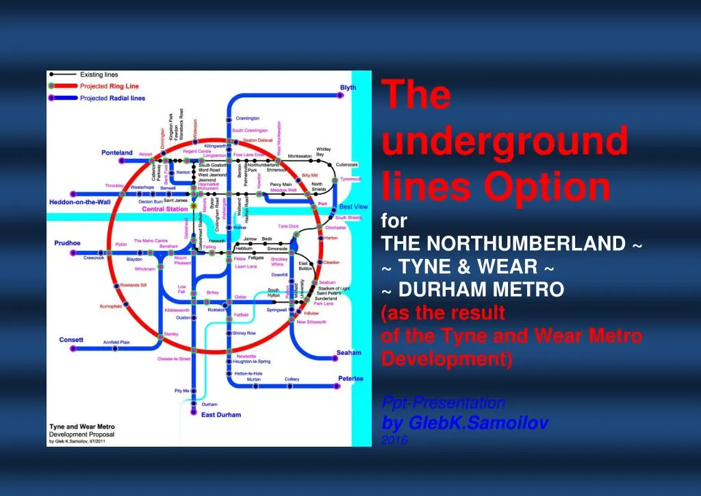
The underground lines Option for THE NORTHUMBERLAND ~ ~ TYNE & WEAR ~ ~ DURHAM METRO (as the result of the Tyne and Wear Metro Development) Ppt-Presentation by GlebK.Samoilov 2016
The underground lines Option for THE NORTHUMBERLAND ~ TYNE & WEAR ~ DURHAM METRO (as the result of the Tyne and Wear Metro Development) /Ppt-Presentation by Gleb K.Samoilov, 2016 1. THE TYNE AND WEAR METRO The Existing position Metro is the main mode of public transport of Tyne and Wear Conurbation. During last 10 years there was steady growth of passenger traffic volume. But now 350 000 inhabitants of the Tyne and Wear, and 290 thousand inhabitants of Northumberland and Durham, who work, rest, study, shop, use the airport, port and railway stations do not have easy access to Metro. There is objective need for the existing Tyne and Wear Metro network expansion. Currently potential of existing surface Metro system completely exhausted. Need to move on to the Modern passenger transport system, off-street transportation, which allows you to cater for the increasing flow of passengers. The optimal solution to the problem at this stage – the creation of advanced network of the Metro. The Basis of this process is the Conception of formation of the Developed network of the Tyne and Wear Metro. 69 author's drawings illustrates the Development Concept Keywords: City Public transport, Metro Ring-radial scheme, Tyne and Wear Metro, Tyne and Wear, Northumberland, Durham, Off-street transport, Urban transport development Source: Drawing by Gleb K.Samoilov, 2013 1
The underground lines Option for THE NORTHUMBERLAND ~ TYNE & WEAR ~ DURHAM METRO (as the result of the Tyne and Wear Metro Development) /Ppt-Presentation by Gleb K.Samoilov, 2016 2. THE ZONE OF OPTIMAL ACCESSIBILITY OF THE TYNE & WEAR METRO EXISTING NETWORK (1,0 km / 0,62 mi to the station) The world practice of Metro systems operation shows that convenient for passengers distance to Metro station – 1.00 km / 0.62 miles. This corresponds to: 15 minutes walking; 5 minutes on a scooter; 3 minutes on a bike; 2 stops by bus. However, the existing network of Tyne and Wear Metro does not cover all potential passengers. Firstly, more than 300 thousand inhabitants of certain areas of Tyne and Wear County (Newcastle upon Tyne, Castle Ward, Longbenton, Gateshead, Sunderland – partly, New Byrn, Ryton, Blaydon, Whickham, Chester-le-Street, Washington, Houghton-le-Spring, Easington, Hetton – completely) denied from easy access to Metro. Secondly, about 280 000 of integrated to public transport system Tyne and Wear (working, studying, shopping, recreation, airoport, port, railway stations) residents of Nortumberland and Durham (Seaham, Peterlee, Durham, Chester-le-Street, Consett, Stanley, Prudhoe, Ponteland, Cramlington, Blyth) are deprived of a convenient connection to the Metro. Thirdly, some large residential and industrial areas, shopping centers and places of public entertainment do not have easy and fast connection between them. Providing this connection will increase the quantity of trips. In addition, in the existing network have a number of problems in the area of operation and environmental protection. Source: Samoilov G.K. The Tyne and Wear Metro developed network as the basis of the Urban transport integrated system.– Newcastle-upon-Tyne / Almaty, 2012. – ISBN 978-601-06-1769-8 2
The underground lines Option for THE NORTHUMBERLAND ~ TYNE & WEAR ~ DURHAM METRO (as the result of the Tyne and Wear Metro Development) /Ppt-Presentation by Gleb K.Samoilov, 2016 3. The TYNE AND WEAR METRO Existing and Unused routes The Type of the Metro system: Rapid transit / Light rail; Line length: 77.7 km (48.3 mi). Includes about 45 km converted railway line, opened in 1839. Operating in the heart of Newcastle as a full-fledged Subway, on the outskirts is the intersection with the highways and at one site using one way with commuter trains. Predominantly terrestrial. Modern Route Services: THE GREEN LINE (Airport – Central Station – South Hylton) and THE YELLOW LINE (Saint James – Tynemouth – Central Station – South Shields). One of the features of the Metro system is to route the Yellow line, which includes the Large Loop. Because of this Tyne-and-Wear Metro is one of two of the world’s metro systems in which a train, following the same route twice passes the same station (the other - in Vancouver). Now the situation with the availability of public transport in the Conurbation became much more complex. In the new phase of development, I think that the entire network of Tyne and Wear Metro must be underground. First, the new lines, and then, gradually, all now existing ones. It’s expensive, but other attempts to solve the problem are even more expensive. In addition, the lines laid underground allow making stations in those places where they are needed most to residents. The existing network of Tyne and Wear Metro distance between the stations is too short. This technology is not convenient for the train. This is inconvenient for passengers. Bridges are a very important aspect. Now the only metro bridge makes it impossible to carry out repairs without disrupting the right bank and left bank of the Tyne River. Source: Drawing by Gleb K.Samoilov, 2013 3
The underground lines Option for THE NORTHUMBERLAND ~ TYNE & WEAR ~ DURHAM METRO (as the result of the Tyne and Wear Metro Development) /Ppt-Presentation by Gleb K.Samoilov, 2016 4. The Concept of THE NORTHUMBERLAND ~ TYNE&WEAR ~ DURHAM METRO as the result of the Tyne and Wear Metro development (the Map) Now the situation with the availability of public transport in the Conurbation became much more complex. In the new phase of development, I think that the entire network of Tyne and Wear Metro must be underground. First, the new lines, and then, gradually, all now existing ones. It’s expensive, but other attempts to solve the problem are even more expensive. In addition, the lines laid underground allow making stations in those places where they are needed most to residents. In this situation, it is expedient to intensive development of the Metro. It will be the basis of all types of Internal and External Public Transport Integration. Geographical features of the location of key elements of the external and internal public transportation, residential districts and working areas, places of mass recreation and entertainment, shopping and educational facilities, stadiums and health-sports centers, historical sites and precious natural landscapes of the Tyne and Wear Conurbation determine the acceptable type of Metro scheme. In international practice for similar situations with a polycentric location of objects successfully applied Complex Loop-shaped schemes and Ring-Radial schemes. Complex Loop-shaped and Ring-Radial schemes are often used in the international practice of metro building. In most cases the Metro –it’s a combination of ground and underground lines. Ground and underground lines have different lengths. Source: Samoilov G.K. The Tyne and Wear Metro developed network as the basis of the Urban transport integrated system.– Newcastle-upon-Tyne / Almaty, 2012. – ISBN 978-601-06-1769-8 4
The underground lines Option for THE NORTHUMBERLAND ~ TYNE & WEAR ~ DURHAM METRO (as the result of the Tyne and Wear Metro Development) /Ppt-Presentation by Gleb K.Samoilov, 2016 5. The Concept of THE NORTHUMBERLAND ~ TYNE&WEAR ~ DURHAM METRO as the result of the Tyne and Wear Metro development (the Scheme) In mid-2011 published “THE TYNE AND WEAR METRO DEVELOPMENT PROPOSAL –2011” (by Gleb K.Samoilov, July 2011). THE NORTHUMBERLAND – TYNE and WEAR – DURHAM METRO as the result of the Tyne & Wear Metro Development (The First published – July, 28th, 2011) . The Ring line: “SEABURN – PORT – SOUTH CRAMLINGTON – AIRPORT – RYTON – NEWBOTTLE – PARK LANE”. The Diametric line: CRAMLINGTON – PELAW – NEWBOTTLE –PETERLEE”. Radial lines: “SAINT JAMES – THROCKLEY – HEDDON-ON-THE-WALL”; “EAST DURHAM – CHESTER- LE-STREET – LOW FELL (branch on LEAM LANE) – GATESHEAD”; “SOUTH HYLTON – GLEBE – BIRTLEY (branch on FATFIELD) – KIBBLESWORTH – THE METRO CENTRE – RYTON –PRUDHOE”; “CONSETT – STANLEY – WHICKHAM – CENTRAL STATION – MANORS (branch on THE METRO CENTRE – BENSHAM –FELLING)”. Branches of radial lines: ”AIRPORT –PONTELAND”; ”BANK FOOT –HAYMARKET”; ”HOWDON –PORT”; ”SOUTH SHIELDS –TYNEMOUTH”; “REGENT CENTRE – LONGBENTON”. – SOUTH “BLYTH Source: Samoilov G.K. The Tyne and Wear Metro developed network as the basis of the Urban transport integrated system.– Newcastle-upon-Tyne / Almaty, 2012. – ISBN 978-601-06-1769-8 5
The underground lines Option for THE NORTHUMBERLAND ~ TYNE & WEAR ~ DURHAM METRO (as the result of the Tyne and Wear Metro Development) /Ppt-Presentation by Gleb K.Samoilov, 2016 6. The FIRST STAGE of the Tyne and Wear Metro development The First Stage of Development. The Ring line: “SEABURN – PORT – SOUTH CRAMLINGTON – AIRPORT NEWBOTTLE –PARK LANE”. Basic data on the line of the First Stage of Development. The length of the line – 40,230 km / 24,99 miles. The number of stations – 23: - new stations – 17 (Cleadon, Harton, Port, Billy Mill, Seaton Delaval, South Cramlington, Wideopen, Dinnington, Throckley, Burnopfield, Stanley, Chester-le-Street, Newbottle, New Silksworth, Hillview); - rebuild operating stations – 6 (Seaburn, Chichester, Meadow Well, West Monkseaton, Airport, Park Lane); - expand operating stations – 0. The number of interchange nodes – 14: - at new stations – 8 (Port, South Cramlington, Throckley, Ryton, Newbottle, New Silksworth); - at operating stations – 6 (Seaburn, Chichester, Meadow Well, West Monkseaton, Airport, Park Lane). The average distance between stations – 1,89 km / 1,14 miles. The maximum distancebetween stations – 3,560 km / 2,21 miles (Chester-le-Street – Stanley). The minimum distancebetween stations –0,550 km / 0,34 miles (Meadow Well – Port). – RYTON – Ryton, Rowlands Gill, Stanley, Chester-le-Street, Source: Samoilov G.K. The Tyne and Wear Metro developed network as the basis of the Urban transport integrated system.– Newcastle-upon-Tyne / Almaty, 2012. – ISBN 978-601-06-1769-8 6
The underground lines Option for THE NORTHUMBERLAND ~ TYNE & WEAR ~ DURHAM METRO (as the result of the Tyne and Wear Metro Development) /Ppt-Presentation by Gleb K.Samoilov, 2016 7. The SECOND STAGE of the Tyne and Wear Metro development The Second Stage of Development. The Radial line: “BLYTH – SOUTH CRAMLINGTON – PELAW – NEWBOTTLE –PETERLEE”. Basic data on the line of the Second Stage of Development. The length of the line – 26,650 km / 16,56 miles. The number of stations – 18: - new stations – 13 (Blyth, Cramlington, Killingworth, Walker, Leam Lane, Glebe, Fatfield, Shiney Row, Houghton-le-Spring, Hetton-le-Hole, Murton, Colliery, Peterlee); - rebuild operating stations – 3 (Four Lane Ends, Walkergate, Pelaw); - expand operating stations – 2 (South Cramlington, Newbottle). The number of interchange nodes – 8: - at new stations – 3 (Leam Lane, Glebe, Fatfield); - at operating stations – 5 (South Cramlington, Four Lane Ends, Walkergate, Pelaw, Newbottle). The average distance between stations – 1,568 km / 0,97 miles. The maximum distancebetween stations – 3,115 km / 1,96 miles (Blyth – Cramlington). The distancebetween stations –0,800 km / 0,50 miles (Newbottle – Shiney Row). minimum Source: Samoilov G.K. The Tyne and Wear Metro developed network as the basis of the Urban transport integrated system.– Newcastle-upon-Tyne / Almaty, 2012. – ISBN 978-601-06-1769-8 7
The underground lines Option for THE NORTHUMBERLAND ~ TYNE & WEAR ~ DURHAM METRO (as the result of the Tyne and Wear Metro Development) /Ppt-Presentation by Gleb K.Samoilov, 2016 8. The THIRD STAGE of the Tyne and Wear Metro development The Third Stageof Development. The Radialline: “SAINT JAMES – THROCKLEY – HEDDON-ON-THE-WALL”. Basic data on thelineof the Third Stageof Development. The length of theline –6,190 km /3,84miles. The number of stations– 6: - new stations– 4(Benwell, Denton Burn, Westerhope, Heddon-on-the-Wall); - rebuild operating stations– 0(-); - expend operating stations– 2(Saint James, Throckley). The number of interchange nodes – 1: - atnew stations– 0(-); - at operatingstations – 1(Throckley). The average distancebetween /0,77miles. The maximum distancebetween stations – 1,460 km / 0,91 miles (Throckley – Heddon-on-the-Wall). The minimum distancebetween stations –1,165 km / 0,72 miles (Denton Burn – Benwell). stations–1,238 km Source: Samoilov G.K. The Tyne and Wear Metro developed network as the basis of the Urban transport integrated system.– Newcastle-upon-Tyne / Almaty, 2012. – ISBN 978-601-06-1769-8 8
The underground lines Option for THE NORTHUMBERLAND ~ TYNE & WEAR ~ DURHAM METRO (as the result of the Tyne and Wear Metro Development) /Ppt-Presentation by Gleb K.Samoilov, 2016 9. The FOURTH STAGE of the Tyne and Wear Metro development The Fourth Stage of Development. The Radial line: “EAST DURHAM – CHESTER-LE- STREET – LOW FELL (branch on LEAM LANE) – GATESHEAD”. Basic data on lines of the Fourth Stage of Development. The length of the line – 14,220 km / 8,83 miles. The number of stations – 10: - new stations – 7 (East Durham, Durham, Pity Me, Ouston, Kibblesworth, Low Fell, Mount Pleasant); - rebuild operating stations – 1 (Gateshead); - expand operating stations – 2 (Chester-le-Street, Leam Lane). The number of interchange nodes – 6: - at new stations – 3 (Kibblesworth, Low Fell, Mount Pleasant); - at operating stations Gateshead, Leam Lane). The average distance between stations – 1,580 km / 0,98 miles. The maximum distancebetween stations – 3,005 km / 1,87 miles (Chester-le-Street – Pity Me). The minimum distancebetween stations –0,600 km / 0,37 miles (Mount Pleasant – Gateshead). – 3 (Chester-le-Street, Source: Samoilov G.K. The Tyne and Wear Metro developed network as the basis of the Urban transport integrated system.– Newcastle-upon-Tyne / Almaty, 2012. – ISBN 978-601-06-1769-8 9
The underground lines Option for THE NORTHUMBERLAND ~ TYNE & WEAR ~ DURHAM METRO (as the result of the Tyne and Wear Metro Development) /Ppt-Presentation by Gleb K.Samoilov, 2016 10. The FIFTH STAGE of the Tyne and Wear Metro development The Fifth Stage of Development. The Radial line: “SOUTH HYLTON – GLEBE – BIRTLEY (branch KIBBLESWORTH – THE METRO CENTRE – RYTON –PRUDHOE”. Basic data on lines of the Fifth Stage of Development. The length of the line – 18,850 km / 11,85 miles. The number of stations – 12: - new stations – 7 (Birtley, Whickham, The Metro Centre, Blaydon, Crawcrook, Prudhoe, Rickleton); - rebuild operating stations – 0 (-); - expand operating stations – 5 (South Hylton, Glebe, Kibblesworth, Ryton, Fatfield). The number of interchange nodes – 7: - at new stations – 3 (Birtley, Whickham, The Metro Centre); - at operating stations – 4 (Glebe, Kibblesworth, Ryton, Fatfield). The average distance between stations – 1,689 km / 1,05 miles.The maximum distancebetween stations – 2,775 km / 1,72 miles (Glebe – South distancebetween stations –0,815 km / 0,51 miles (The Metro Centre – Whickham). on FATFIELD) – Hylton).The minimum Source: Samoilov G.K. The Tyne and Wear Metro developed network as the basis of the Urban transport integrated system.– Newcastle-upon-Tyne / Almaty, 2012. – ISBN 978-601-06-1769-8 10
The underground lines Option for THE NORTHUMBERLAND ~ TYNE & WEAR ~ DURHAM METRO (as the result of the Tyne and Wear Metro Development) /Ppt-Presentation by Gleb K.Samoilov, 2016 11. The SIXTH STAGE of the Tyne and Wear Metro development The Sixth Stageof Development. The Radialline: “SEAHAM – NEW SILKSWORTH – PALLION –TYNE DOCK”. Basic data on theline of the SixthStage of Development. The length of theline –10,635 km /6,61miles. The number of stations– 7: - new stations– 3(Seaham, Springwell, Downhill); - rebuild operatingstations– 3(Pallion, Brockley Whins, Tyne Dock); - expand operatingstations– 1(New Silksworth). The number of interchange nodes – 4: - at new stations– 0(-); - atoperatingstations– 4(New Brockley Whins, Tyne Dock). The average distancebetween /1,10miles. The maximum distancebetween stations – 2,865 km / 1,78 miles (Seaham – New Silksworth). The minimum distancebetween stations –1,205 km / 0,75 miles (Tyne Dock – Brockley Whins). Silksworth, Pallion, stations–1,773 km Source: Samoilov G.K. The Tyne and Wear Metro developed network as the basis of the Urban transport integrated system.– Newcastle-upon-Tyne / Almaty, 2012. – ISBN 978-601-06-1769-8 11
The underground lines Option for THE NORTHUMBERLAND ~ TYNE & WEAR ~ DURHAM METRO (as the result of the Tyne and Wear Metro Development) /Ppt-Presentation by Gleb K.Samoilov, 2016 12. The SEVENTH STAGE of the Tyne and Wear Metro development The Seventh Stage of Development. The Radial line: “CONSETT – STANLEY – WHICKHAM – CENTRAL STATION – MANORS (branch on THE METRO CENTRE – BENSHAM – FELLING)”. Basic data on lines of the Seventh Stage of Development. The length of the line – 15,115 km / 9,39 miles. The number of stations – 10: - new stations – 3 (Consett, Annfield Plain, Bensham); - rebuild operating stations – 3 (Central Station, Manors, Felling); - expand operating stations – 4 (Stenley, Whickham, The Metro Centre, Mount Pleasant). The number of interchange nodes – 8: - at new stations – 1 (Bensham); - at operating stations – 7 (Stenley, Whickham, Central Station, Manors, The Metro Centre, Mount Pleasant, Felling). The average distance between stations – 2,159 km / 1,34 miles. The maximum distancebetween stations – 4,535 km / 2,82 miles (Whickham – distancebetween stations –0,600 km / 0,37 miles (Central Station – Manors). Stanley). The minimum Source: Samoilov G.K. The Tyne and Wear Metro developed network as the basis of the Urban transport integrated system.– Newcastle-upon-Tyne / Almaty, 2012. – ISBN 978-601-06-1769-8 12
The underground lines Option for THE NORTHUMBERLAND ~ TYNE & WEAR ~ DURHAM METRO (as the result of the Tyne and Wear Metro Development) /Ppt-Presentation by Gleb K.Samoilov, 2016 13. The EIGTH STAGE of the Tyne and Wear Metro development The Eighth Stage of Development. Branches of radial lines: ”AIRPORT –PONTELAND”; ”BANK FOOT –HAYMARKET”; ”HOWDON –PORT”; ”SOUTH SHIELDS –TYNEMOUTH”; “REGENT CENTRE –LONGBENTON”. Basic data on the lines of the Eighth Stage of Development. The length of lines – 8,175 km / 5,08 miles. The number of stations – 12: - new stations – 3 (Ponteland, Kenton, Best View); - rebuild operating stations – 7 (Bank Foot, Haymarket, Howdon, South Shields, Tynemouth, Regent Centre, Longbenton); - expand operating stations – 2 (Airport, Port). The number of interchange nodes – 8: - at new stations – 0 (-); - at operating stations – 6 (Airport, Bank Foot, Haymarket, Howdon, Port, Tynemouth, Regent Centre, Longbenton). The average distance between stations – 1,022 km / 0,64 miles. The maximum distancebetween stations – 1,875 km / 1,17 miles (Haymarket – distancebetween stations –0,475 km / 0,30 miles (South Shields – Best View). Kenton). The minimum Source: Samoilov G.K. The Tyne and Wear Metro developed network as the basis of the Urban transport integrated system.– Newcastle-upon-Tyne / Almaty, 2012. – ISBN 978-601-06-1769-8 13
The underground lines Option for THE NORTHUMBERLAND ~ TYNE & WEAR ~ DURHAM METRO (as the result of the Tyne and Wear Metro Development) /Ppt-Presentation by Gleb K.Samoilov, 2016 14. The NINTH STAGE of the Tyne and Wear Metro development After completing the bulk of the work on the Eighth stage of the Tyne and Wear Metro Development appropriate to make underground and most of the existing Metro lines. It can be classified as the Ninth Stage of Development or the Final part of Eighth Stage of Basic Version (the Final part of Third Stage of the Alternative Version). In this trace does not change. Underground will be the following sites: AIRPORT – Callerton Parkway – Bank Foot – Kingston Park – Fawdon – Wansbeck Road – REGENT CENTRE; SOUTH GOSFORTH – Ilford Road – West Jesmond – JESMOND; LONGBENTON – Four Lane Ends – BENTON; PALMERSVILLE – Northumberland Park – Shiremoor – West Monkseaton – Whitley Bay – Cullercoats – Tynemouth – North Shields – Meadow Well – Percy Main – Howdon – Hadrian Road – Wallsend – Walkergate – Chillingham Road – Byker – MANORS; HEBBURN – Jarrow – Bede – Simonside – TYNE DOCK – Chichester – SOUTH SHIELDS; PELAW – Fellgate – BROCKLEY WHINS – East Boldon – Seaburn – Stadium of Light –SAINT PETER’S; MILLFIELD – Pallion – SOUTH HYLTON. The underground section (PELAW – Fellgate – BROCKLEY WHINS – East Boldon – Seaburn – Stadium of Light – SAINT PETER’S) to the joint operation with Railway Companies. No change in ground situation will remain the following sites: REGENT CENTRE – LONGBENTON – SOUTH GOSFORTH – REGENT CENTRE (connection to the Depot); BENTON – PALMERSVILLE; GATESHEAD STADIUM – Felling – Heworth – PELAW (Difficult connections with the Railway network). Source: Samoilov G.K. The Tyne and Wear Metro developed network as the basis of the Urban transport integrated system.– Newcastle-upon-Tyne / Almaty, 2012. – ISBN 978-601-06-1769-8 14
The underground lines Option for THE NORTHUMBERLAND ~ TYNE & WEAR ~ DURHAM METRO (as the result of the Tyne and Wear Metro Development) /Ppt-Presentation by Gleb K.Samoilov, 2016 15. The Boulevard on Old surface lines of the Northumberland – Tyne and Wear – Durham Metro Surface location of the Tyne & Wear Metro lines has a negative impact on the environment and complicates the normal operation of road transport: Electromagnetic radiation; Noise impact; Single-level crossings create traffic delays and increase the level of emissions due to the acceleration of vehicles after the intersection. The Northumberland – Tyne & Wear – Durham Metro network only involves the construction of underground lines. After completion of the Northumberland – Tyne & Wear – Durham line of the existing ground leaving only the following sites: - Regent Centre – Longbenton – South Gosforth (exit metro- trains in tunnels at the Depot); - Benton – Palmersville and part of the site of the Northumberland Park – Shiremoor (exit metro-trains to Regional rail system); - Gateshead Stadium – Felling – Heworth – Pelaw – a bifurcation in Hebburn and Fellgate (exit metro-trains to Regional rail system and the site of joint operation of the Tyne & Wear Metro and Regional railways); - the Existing Bridge over the River Tyne (Central Station – Gateshead segment); - the Existing Bridge over the River Wear (segment near the station Sunderland); - the New Bridge over the River Tyne with the Best View Station at South Shields – Tynemouth segment. Other sites that prior to the intensive construction of the NORTHUMBERLAND – TYNE & WEAR – DURHAM METRO lines were occupied land, I consider it expedient to turn to beautiful parks charming boulevards. Source: Samoilov G.K. The Tyne and Wear Metro developed network as the basis of the Urban transport integrated system.– Newcastle-upon-Tyne / Almaty, 2012. – ISBN 978-601-06-1769-8 15
The underground lines Option for THE NORTHUMBERLAND ~ TYNE & WEAR ~ DURHAM METRO (as the result of the Tyne and Wear Metro Development) /Ppt-Presentation by Gleb K.Samoilov, 2016 16. The Alternative FIRST STAGE of the Tyne and Wear Metro development The First Stage of Development (the Alternative). The Radial (Diametral) line –“BLYTH – SOUTH CRAMLINGTON – FOUR LANE ENDS – WALKERGATE – PELAW – LEAM LANE – LOW FELL – KIBBLESWORTH – CHESTER-LE-STREET –EAST DURHAM”. Source: Samoilov G.K. The Tyne and Wear Metro developed network as the basis of the Urban transport integrated system.– Newcastle-upon-Tyne / Almaty, 2012. – ISBN 978-601-06-1769-8 16
The underground lines Option for THE NORTHUMBERLAND ~ TYNE & WEAR ~ DURHAM METRO (as the result of the Tyne and Wear Metro Development) /Ppt-Presentation by Gleb K.Samoilov, 2016 17. The Alternative SECOND STAGE of the Tyne and Wear Metro development The Second Stage of Development (the Alternative). Several Radial branches. The Radial line-1 –“LEAM LANE – GLEBE – FATFIELD – NEWBOTTLE – HETTON-LE-HOLE – PETERLEE”: The Radial line-2 –“LOW FELL – MOUNT PLEASANT –GATESHEAD”: The Radial line-3 –“SAINT JAMES – THROCKLEY – HEDDON- ON-THE-WALL”: The Radial line-4 –“SOUTH HYLTON – GLEBE – BIRTLEY (branch on FATFIELD) – KIBBLESWORTH – THE METRO CENTRE – RYTON –PRUDHOE”: The Radial line-5 –“SEAHAM – NEW SILKSWORTH – PALLION –TYNE DOCK”: The Radial line-6 –“CONSETT – STANLEY – WHICKHAM – CENTRAL STATION – MANORS (branch on THE METRO CENTRE – BENSHAM – FELLING)”: Branches of radial lines: “AIRPORT – PONTELAND”; ”BANK FOOT –HAYMARKET”; ”HOWDON –PORT”; ”SOUTH SHIELDS – TYNEMOUTH;“REGENT LONGBENTON”. – CENTRE Source: Samoilov G.K. The Tyne and Wear Metro developed network as the basis of the Urban transport integrated system.– Newcastle-upon-Tyne / Almaty, 2012. – ISBN 978-601-06-1769-8 17
The underground lines Option for THE NORTHUMBERLAND ~ TYNE & WEAR ~ DURHAM METRO (as the result of the Tyne and Wear Metro Development) /Ppt-Presentation by Gleb K.Samoilov, 2016 18. The Alternative THIRD STAGE of the Tyne and Wear Metro development The Third Stage of Development (the Alternative). The Ring line, uniting all radial branches – “SEABURN – PORT – SOUTH CRAMLINGTON – AIRPORT – RYTON – NEWBOTTLE – PARK LANE”. Source: Samoilov G.K. The Tyne and Wear Metro developed network as the basis of the Urban transport integrated system.– Newcastle-upon-Tyne / Almaty, 2012. – ISBN 978-601-06-1769-8 18
The underground lines Option for THE NORTHUMBERLAND ~ TYNE & WEAR ~ DURHAM METRO (as the result of the Tyne and Wear Metro Development) /Ppt-Presentation by Gleb K.Samoilov, 2016 19. TheNORTHUMBERLAND ~ TYNE&WEAR ~ DURHAM METRO as the result of the Tyne and Wear Metro development (the Scheme) The Development Result of the Tyne and Wear Metro network will be the emergence of a regional system“NORTHUMBERLAND – TYNE and WEAR –DURHAM METRO”.It allows you to solve the problem of convenient transportation access to the entire North-East Region. General indicators of the NORTHUMBERLAND – TYNE & WEAR – DURHAM METRO: The total length of new lines – 138.810 km / 85.25 miles. The total number of new stations – 57. The average distance between stations – 1.633 km / 1.01 miles.The maximum distance between stations – 4.535 km / 2.82 miles.The shortest distance between stations – 0.475 km / 0.30 miles (the original Station “Best View” at the New Bridge). The total number of stations after the Eighth stage of Development – 117 (before the First stage of Development – 60). The average distance between stations – 1.491 km / 0.92 miles (before the First stage of Development – 1.359 km / 0.84 miles). The total number of developed operating stations – 24. The number of interchange nodes – 40: at new stations – 18; at developed operating stations – 22. Source: Samoilov G.K. The Tyne and Wear Metro developed network as the basis of the Urban transport integrated system.– Newcastle-upon-Tyne / Almaty, 2012. – ISBN 978-601-06-1769-8 19
The underground lines Option for THE NORTHUMBERLAND ~ TYNE & WEAR ~ DURHAM METRO (as the result of the Tyne and Wear Metro Development) /Ppt-Presentation by Gleb K.Samoilov, 2016 20. The Operated routes of the Tyne and Wear Metro in the Developed network structure The exists Route “The Green Line”(South Hylton, Pallion, Millfield, University, Park Lane, Sunderland, Saint Peter’s, Stadium of Light, Seaburn, East Boldon, Brockley Whins, Fellgate, Pelaw, Felling, Gateshead Stadium, Gateshead, Central Station, Monument, Haymarket, Jesmond, West Jesmond, Ilford Road, South Gosforth, Regent Centre, Wansbeck Road, Fawdon, Kingston Park, Bank Foot, Callerton Parkway, Airport) and the exists Route “The Yellow Line”(South Shields, Chichester, Tyne Dock, Bede, Jarrow, Hebburn, Pelaw, Felling, Gateshead Stadium, Gateshead, Central Station, Monument, Haymarket, Jesmond, West Jesmond, Ilford Road, South Gosforth, Longbenton, Four Lane Ends, Benton, Palmersville, Shiremoor, West Monkseaton, Monkseaton, Whitley Bay, Cullercoats, Tynemouth, North Shields, Meadow Well, Percy Main, Howdon, Hadrian Road, Wallsend, Walkergate, Chillingham Road, Byker, Manors, Monument, Saint James) is fully or partially included in most of New routes. They are the basis for the formation of new routes, which will appear as the implementation of the First, Second, Third, Fourth, Fifth, Sixth, Seventh and Eighth stages of the Development. Routes network of the Northumberland – Tyne and Wear – Durham Metro consist of 45 routes:5 Routes of “The Ring” (R) type;4 Routes of “The Double Ring” (DR) type;3 Routes of “The Double Loop” (DL) type;1 Routes of “The Complex Loop” (CL) type;5 Routes of “The Big Loop” (BL) type;9 Routes of “The Small Loop” (SL) type;5 Routes of “The Big Wave” (BW) type;11 Routes of “The Long Radial Wave” (LRW) type;2 Routes of “The Small Radial Wave” (SRW) type. Source: Samoilov G.K. The Tyne and Wear Metro developed network as the basis of the Urban transport integrated system.– Newcastle-upon-Tyne / Almaty, 2012. – ISBN 978-601-06-1769-8 20
The underground lines Option for THE NORTHUMBERLAND ~ TYNE & WEAR ~ DURHAM METRO (as the result of the Tyne and Wear Metro Development) /Ppt-Presentation by Gleb K.Samoilov, 2016 21. Proposed Routes of the Northumberland – Tyne and Wear – Durham Metro “THE GRAND RING” – GR The Route “The Grand Ring” (GR). This Route has 26 stations (14 interchange nodes): Sunderland (the Initial station / the Final station – conditionally), Saint Peter’s, Stadium of Light, Seaburn (the Interchange node), Cleadon, Harton, Chichester (the Interchange node), Port (the Interchange node), Meadow Well (the Interchange node), Billy Mill, West Monkseaton (the Interchange node), Seaton Delaval, South Cramlington (the Interchange node), Wideopen, Dinnington, Airport (the Interchange node), Throckley (the Interchange node), Ryton (the Interchange node), Rowlands Gill, Burnopfield, Stanley (the Interchange node), Chester-le-Street (the Interchange node), Newbottle (the Interchange node), New Silksworth (the Interchange node), Hillview, Park Lane (the Interchange node), Sunderland (the Initial station / the Final station – conditionally). Source: Samoilov G.K. The Tyne and Wear Metro developed network as the basis of the Urban transport integrated system.– Newcastle-upon-Tyne / Almaty, 2012. – ISBN 978-601-06-1769-8 21
The underground lines Option for THE NORTHUMBERLAND ~ TYNE & WEAR ~ DURHAM METRO (as the result of the Tyne and Wear Metro Development) /Ppt-Presentation by Gleb K.Samoilov, 2016 22. Proposed Routes of the Northumberland – Tyne and Wear – Durham Metro “THE NORTH TYNESIDE RING” – NTsR The Route “The North Tyneside Ring” (NTsR). This Route has 31 stations (12 interchange nodes): South Shields (the Initial station / the Final station – conditionally), Best View, Tynemouth (the Interchange node), Monkseaton, West Monkseaton (the Interchange node), Shiremoor, Northumberland Park, Palmersville, Benton, Four Lane Ends (the Interchange node), Longbenton (the Interchange node), South Gosforth (the Interchange node), Ilford Road, West Jesmond, Jesmond, Haymarket (the Interchange node), Monument (the Interchange node), Central Station (the Interchange node), Gateshead (the Interchange node), Gateshead Stadium, Felling (the Interchange node), Heworth, Pelaw (the Interchange node), Hebburn, Jarrow, Bede, Simonside, Tyne Dock (the Interchange node), Chichester (the Interchange node), South Shields (the Initial station / the Final station – conditionally). Cullercoats, Whitley Bay, Source: Samoilov G.K. The Tyne and Wear Metro developed network as the basis of the Urban transport integrated system.– Newcastle-upon-Tyne / Almaty, 2012. – ISBN 978-601-06-1769-8 22
The underground lines Option for THE NORTHUMBERLAND ~ TYNE & WEAR ~ DURHAM METRO (as the result of the Tyne and Wear Metro Development) /Ppt-Presentation by Gleb K.Samoilov, 2016 23. Proposed Routes of the Northumberland – Tyne and Wear – Durham Metro “THE SOUTH TYNESIDE RING” – STsR The Route “The South Tyneside Ring” (STsR). This Route has 26 stations (14 interchange nodes): Central Station (the Interchange node: the Initial station / the Final station – conditionally), Manors (the Interchange node), Byker, Chillingham Road, Walkergate (the Interchange node), Wallsend, Hadrian Road, Howdon (the Interchange node), Port (the Interchange node), Chichester (the Interchange node), Harton, Cleadon, Seaburn (the Interchange node), Stadium of Light, Saint Peter’s, Sunderland, Park Lane (the Interchange node), University, Millfield, Pallion (the Interchange node), South Hylton, Glebe (the Interchange node), Birtley (the Interchange node), Kibblesworth (the Interchange node), Whickham (the Interchange node), Bensham (the Interchange node), Central Station (the Interchange node: the Initial station / the Final station – conditionally). Source: Samoilov G.K. The Tyne and Wear Metro developed network as the basis of the Urban transport integrated system.– Newcastle-upon-Tyne / Almaty, 2012. – ISBN 978-601-06-1769-8 23
The underground lines Option for THE NORTHUMBERLAND ~ TYNE & WEAR ~ DURHAM METRO (as the result of the Tyne and Wear Metro Development) /Ppt-Presentation by Gleb K.Samoilov, 2016 24. Proposed Routes of the Northumberland – Tyne and Wear – Durham Metro “THE SMALL RING” – SR The Route “The Small Ring” (SR). This Route has 21 stations (11 interchange nodes): Pelaw (the Interchange node: the Initial station / the Final station – conditionally), Fellgate, Brockley Whins (the Interchange node), East Boldon, Seaburn (the Interchange node), Stadium of Light, Saint Peter’s, Sunderland, Park Lane (the Interchange node), University, Millfield, Pallion (the Interchange node), South Hylton, Glebe (the Interchange node), Birtley (the Interchange node), Kibblesworth (the Interchange node), Whickham (the Interchange node), Bensham (the Interchange node), Mount Pleasant (the Interchange node), Felling (the Interchange node), Heworth, Pelaw (the Interchange node: the Initial station / the Final station – conditionally). Source: Samoilov G.K. The Tyne and Wear Metro developed network as the basis of the Urban transport integrated system.– Newcastle-upon-Tyne / Almaty, 2012. – ISBN 978-601-06-1769-8 24
The underground lines Option for THE NORTHUMBERLAND ~ TYNE & WEAR ~ DURHAM METRO (as the result of the Tyne and Wear Metro Development) /Ppt-Presentation by Gleb K.Samoilov, 2016 25. Proposed Routes of the Northumberland – Tyne and Wear – Durham Metro “THE COMPLEX RING” – CR The Route “The Complex Ring” (CR). This Route has 51 stations (26 interchange nodes):Glebe (the Interchange node: the Initial station / the Final station – conditionally), South Hylton, Pallion (the Interchange node), Millfield, University, Park Lane (the Interchange node), Sunderland, Saint Peter’s, Stadium of Light, Seaburn (the Interchange node), East Boldon, Brockley Whins (the Interchange node), Fellgate, Pelaw (the Interchange node), Heworth, Felling (the Interchange node), Gateshead Stadium, Gateshead (the Interchange node), Central Station (the Interchange node), Manors (the Interchange node), Byker, Chillingham Interchange node), Wallsend, Hadrian Road, Howdon (the Interchange node), Percy Main, Meadow Well (the Interchange node), North Shields, Tynemouth (the Interchange node), Monkseaton, West Monkseaton (the Interchange node), Shiremoor, Northumberland Park, Palmersville, Benton, Four Lane Ends (the Interchange node), Longbenton (the Interchange node), South Gosforth (the Interchange node), Ilford Road, West Jesmond, Jesmond, Haymarket (the Interchange node), Monument (the Interchange node), Central Station (the Interchange node), Bensham (the Interchange node), Whickham (the Interchange node), Kibblesworth (the Interchange node), Birtley (the Interchange node), Glebe (the Interchange node: the Initial station / the Final station – conditionally). Road, Walkergate (the Cullercoats, Whitley Bay, Source: Samoilov G.K. The Tyne and Wear Metro developed network as the basis of the Urban transport integrated system.– Newcastle-upon-Tyne / Almaty, 2012. – ISBN 978-601-06-1769-8 25
The underground lines Option for THE NORTHUMBERLAND ~ TYNE & WEAR ~ DURHAM METRO (as the result of the Tyne and Wear Metro Development) /Ppt-Presentation by Gleb K.Samoilov, 2016 26. Proposed Routes of the Northumberland – Tyne and Wear – Durham Metro “THE DOUBLE RING - 1” – DR-1 The Route “The Double Ring -1” (DR-1). This Route has 77 stations (40 interchange nodes): Seaburn (the Interchange node: the Initial station / the Final station – conditionally), East Boldon, Brockley Whins (the Interchange node), Fellgate, Pelaw (the Interchange node), Heworth, Felling (the Interchange node), Gateshead Stadium, Gateshead (the Interchange node), Central Station (the Interchange node), Manors (the Interchange node), Byker, Chillingham Road, Walkergate (the Interchange node), Wallsend, Hadrian Road, Howdon (the Interchange node), Percy Main, Meadow Well (the Interchange node), North Shields, Tynemouth (the Interchange node), Cullercoats, Whitley Bay, Monkseaton, West Monkseaton (the Interchange node), Shiremoor, Northumberland Park, Palmersville, Benton, Four Lane Ends (the Interchange node), Longbenton (the Interchange node), South Gosforth (the Interchange node), Ilford Road, West Jesmond, Jesmond, Haymarket (the Interchange node), Monument (the Interchange node), Central Station (the Interchange node), Bensham (the Interchange node), Whickham (the Interchange node), Kibblesworth (the Interchange node), Birtley (the Interchange node), Glebe (the Interchange node), South Hylton, Pallion (the Interchange node), Millfield, University, Park Lane (the Interchange node), Sunderland, Saint Peter’s, Stadium of Light, Seaburn (the Interchange node), Cleadon, Harton, Chichester (the Interchange node), Port (the Interchange node), Meadow Well (the Interchange node), Billy Mill, West Monkseaton (the Interchange node), Seaton Delaval, South Cramlington (the Interchange node), Wideopen, Dinnington, Airport (the Interchange node), Throckley (the Interchange node), Ryton (the Interchange node), Rowlands Gill, Burnopfield, Stanley (the Interchange node), Chester-le-Street (the Interchange node), Newbottle (the Interchange node), New Silksworth (the Interchange node), Hillview, Park Lane (the Interchange node), Sunderland, Saint Peter’s, Stadium of Light, Seaburn (the Interchange node: the Initial station / the Final station – conditionally). Source: Samoilov G.K. The Tyne and Wear Metro developed network as the basis of the Urban transport integrated system.– Newcastle-upon-Tyne / Almaty, 2012. – ISBN 978-601-06-1769-8 26
The underground lines Option for THE NORTHUMBERLAND ~ TYNE & WEAR ~ DURHAM METRO (as the result of the Tyne and Wear Metro Development) /Ppt-Presentation by Gleb K.Samoilov, 2016 27. Proposed Routes of the Northumberland – Tyne and Wear – Durham Metro “THE DOUBLE RING - 2” – DR-2 The Route “The Double Ring -2” (DR-2). This Route has 52 stations (28 interchange nodes): Seaburn (the Interchange node: the Initial station / the Final station – conditionally), Cleadon, Harton, Chichester (the Interchange node), Port (the Interchange node), Howdon (the Interchange node), Hadrian Road, Wallsend, Walkergate (the Interchange node), Chillingham Road, Byker, Manors (the Interchange node), Central Station (the Interchange node), Bensham (the Interchange node), Whickham (the Interchange node), Kibblesworth (the Interchange node), Birtley (the Interchange node), Glebe (the Interchange node), South Hylton, Pallion (the Interchange node), Millfield, University, Park Lane (the Interchange node), Sunderland, Saint Peter’s, Stadium of Light, Seaburn (the Interchange node), Cleadon, Harton, Chichester (the Interchange node), Port (the Interchange node), Meadow Well (the Interchange node), Billy Mill, West Monkseaton (the Interchange node), Seaton Delaval, South Cramlington (the Interchange node), Wideopen, Dinnington, Airport (the Interchange node), Throckley (the Interchange node), Ryton (the Interchange node), Rowlands Gill, Burnopfield, Stanley (the Interchange node), Chester-le- Street (the Interchange node), Newbottle (the Interchange node), New Silksworth (the Interchange node), Hillview, Park Lane (the Interchange node), Sunderland, Saint Peter’s, Stadium of Light, Seaburn (the Interchange node: the Initial station / the Final station – conditionally). Source: Samoilov G.K. The Tyne and Wear Metro developed network as the basis of the Urban transport integrated system.– Newcastle-upon-Tyne / Almaty, 2012. – ISBN 978-601-06-1769-8 27
The underground lines Option for THE NORTHUMBERLAND ~ TYNE & WEAR ~ DURHAM METRO (as the result of the Tyne and Wear Metro Development) /Ppt-Presentation by Gleb K.Samoilov, 2016 28. Proposed Routes of the Northumberland – Tyne and Wear – Durham Metro “THE DOUBLE RING - 3” – DR-3 The Route “The Double Ring -3” (DR-3). This Route has 47 stations (25 interchange nodes): Sunderland (the Initial station / the Final station – conditionally), Saint Peter’s, Stadium of Light, Seaburn (the Interchange node), Cleadon, Harton, Chichester (the Interchange node), Port (the Interchange node), Meadow Well (the Interchange node), Billy Mill, West Monkseaton (the Interchange node), Seaton Delaval, South Cramlington (the Interchange node), Wideopen, Dinnington, Airport (the Interchange node), Throckley (the Interchange node), Ryton (the Interchange node), Rowlands Gill, Burnopfield, Stanley (the Interchange node), Chester-le-Street (the Interchange node), Newbottle (the Interchange node), New Silksworth (the Interchange node), Hillview, Park Lane (the Interchange node), Sunderland, Saint Peter’s, Stadium of Light, Seaburn (the Interchange node), East Boldon, Brockley Whins (the Interchange node), Fellgate, Pelaw (the Interchange node), Heworth, Felling (the Interchange node), Mount Pleasant (the Interchange node), Bensham (the Interchange node), Whickham (the Interchange node), Kibblesworth (the Interchange node), Kibblesworth (the Interchange node), Birtley (the Interchange node), Glebe (the Interchange node), South Hylton, Pallion (the Interchange node), Millfield, University, Park Lane (the Interchange node), Sunderland (the Initial station / the Final station – conditionally). Source: Samoilov G.K. The Tyne and Wear Metro developed network as the basis of the Urban transport integrated system.– Newcastle-upon-Tyne / Almaty, 2012. – ISBN 978-601-06-1769-8 28
The underground lines Option for THE NORTHUMBERLAND ~ TYNE & WEAR ~ DURHAM METRO (as the result of the Tyne and Wear Metro Development) /Ppt-Presentation by Gleb K.Samoilov, 2016 29. Proposed Routes of the Northumberland – Tyne and Wear – Durham Metro “THE DOUBLE RING - 4” – DR-4 The Route “The Double Ring -4” (DR-4). This Route has 52 stations (23 interchange nodes): Pelaw (the Interchange node: the Initial station / the Final station – conditionally), Hebburn, Jarrow, Bede, Simonside, Tyne Dock (the Interchange node), Chichester (the Interchange node), South Shields, Best View, Tynemouth (the Interchange node), Cullercoats, Whitley Bay, Monkseaton, West Monkseaton (the Interchange node), Shiremoor, Northumberland Park, Palmersville, Benton, Four Lane Ends (the Interchange node), Longbenton (the Interchange node), South Gosforth (the Interchange node), Ilford Road, West Jesmond, Jesmond, Haymarket (the Interchange node), Monument (the Interchange node), Central Station (the Interchange node), Gateshead (the Interchange node), Gateshead Stadium, Felling (the Interchange node), Heworth, Pelaw (the Interchange node), Fellgate, Brockley Whins (the Interchange node), East Boldon, Seaburn (the Interchange node), Stadium of Light, Saint Peter’s, Sunderland, Park Lane (the Interchange node), University, Millfield, Pallion (the Interchange node), South Hylton, Glebe (the Interchange node), Birtley (the Interchange node), Kibblesworth (the Interchange node), Whickham (the Interchange node), Bensham (the Interchange node), Mount Pleasant (the Interchange node), Felling (the Interchange node), Heworth, Pelaw (the Interchange node: the Initial station / the Final station – conditionally). Source: Samoilov G.K. The Tyne and Wear Metro developed network as the basis of the Urban transport integrated system.– Newcastle-upon-Tyne / Almaty, 2012. – ISBN 978-601-06-1769-8 29
The underground lines Option for THE NORTHUMBERLAND ~ TYNE & WEAR ~ DURHAM METRO (as the result of the Tyne and Wear Metro Development) /Ppt-Presentation by Gleb K.Samoilov, 2016 30. Proposed Routes of the Northumberland – Tyne and Wear – Durham Metro “THE SMALL LOOP - 1” – SL-1 The Route “The Small Loop -1” (SL-1). This Route has 31 stations (16 interchange nodes): Prudhoe (the Initial station / the Final station – conditionally), Crawcrook, Ryton (the Interchange node), Blaydon, The Metro Centre (the Interchange node), Whickham (the Interchange node), Kibblesworth (the Interchange node), Birtley (the Interchange node), Glebe (the Interchange node), South Hylton, Pallion (the Interchange node), Millfield, University, Park Lane (the Interchange node), Sunderland, Saint Peter’s, Stadium of Light, Seaburn (the Interchange node), East Boldon, Brockley Whins (the Interchange node), Fellgate, Pelaw (the Interchange node), Heworth, Felling (the Interchange node), Mount Pleasant (the Interchange node), Bensham (the Interchange node), The Metro Centre (the Interchange node), Blaydon, Ryton (the Interchange node), Crawcrook, Prudhoe (the Initial station / the Final station – conditionally). Source: Samoilov G.K. The Tyne and Wear Metro developed network as the basis of the Urban transport integrated system.– Newcastle-upon-Tyne / Almaty, 2012. – ISBN 978-601-06-1769-8 30
The underground lines Option for THE NORTHUMBERLAND ~ TYNE & WEAR ~ DURHAM METRO (as the result of the Tyne and Wear Metro Development) /Ppt-Presentation by Gleb K.Samoilov, 2016 31. Proposed Routes of the Northumberland – Tyne and Wear – Durham Metro “THE SMALL LOOP - 2” – SL-2 The Route “The Small Loop -2” (SL-2). This Route has 38 stations (22 interchange nodes): Ponteland (the Initial station / the Final station – conditionally), Airport (the Interchange node), Callerton Parkway, Bank Foot (the Interchange node), Kenton, Haymarket (the Interchange node), Monument (the Interchange node), Central Station (the Interchange node), Bensham (the Interchange node), Whickham (the Interchange node), Kibblesworth (the Interchange node), Birtley (the Interchange node), Glebe (the Interchange node), South Hylton, Pallion (the Interchange node), Millfield, University, Park Lane (the Interchange node), Sunderland, Saint Peter’s, Stadium of Light, Seaburn (the Interchange node), East Boldon, Brockley Whins (the Interchange node), Fellgate, Pelaw (the Interchange node), Heworth, Felling (the Interchange node), Gateshead Stadium, Gateshead (the Interchange node), Central Station (the Interchange node), Monument (the Interchange node), Haymarket (the Interchange node), Kenton, Bank Foot (the Interchange node), Callerton Parkway, Airport (the Interchange node), Ponteland (the Initial station / the Final station – conditionally). Source: Samoilov G.K. The Tyne and Wear Metro developed network as the basis of the Urban transport integrated system.– Newcastle-upon-Tyne / Almaty, 2012. – ISBN 978-601-06-1769-8 31
The underground lines Option for THE NORTHUMBERLAND ~ TYNE & WEAR ~ DURHAM METRO (as the result of the Tyne and Wear Metro Development) /Ppt-Presentation by Gleb K.Samoilov, 2016 32. Proposed Routes of the Northumberland – Tyne and Wear – Durham Metro “THE SMALL LOOP - 3” – SL-3 The Route “The Small Loop -3” (SL-3). This Route has 46 stations (18 interchange nodes): Chichester (the Interchange node – the Initial station / the Final station – conditionally), Tyne Dock (the Interchange node), Simonside, Bede, Jarrow, Hebburn, Pelaw (the Interchange node), Felling (the Interchange node), Heworth, Gateshead Stadium, Gateshead (the Interchange node), Central Station (the Interchange node), Monument (the Interchange node), Haymarket (the Interchange node), Jesmond, West Jesmond, Ilford Road, South Gosforth (the Interchange node), Longbenton (the Interchange node), Four Lane Ends (the Interchange node), Benton, Palmersville, Northumberland Park, Shiremoor, West Monkseaton (the Interchange node), Monkseaton, Whitley Bay, Cullercoats, Tynemouth (the Interchange node), North Shields, Meadow Well (the Interchange node), Percy Main, Howdon (the Interchange node), Hadrian Road, Wallsend, Walkergate (the Interchange node), Chillingham Road, Byker, Manors (the Interchange node), Monument (the Interchange node), Saint James, Benwell, Denton Burn, Westerhope, Throckley, Heddon-on-the- Wall (the Initial station / the Final station – conditionally). Source: Samoilov G.K. The Tyne and Wear Metro developed network as the basis of the Urban transport integrated system.– Newcastle-upon-Tyne / Almaty, 2012. – ISBN 978-601-06-1769-8 32
The underground lines Option for THE NORTHUMBERLAND ~ TYNE & WEAR ~ DURHAM METRO (as the result of the Tyne and Wear Metro Development) /Ppt-Presentation by Gleb K.Samoilov, 2016 33. Proposed Routes of the Northumberland – Tyne and Wear – Durham Metro “THE SMALL LOOP - 4” – SL-4 The Route “The Small Loop -4” (SL-4). This Route has 41 stations (17 interchange nodes): Prudhoe (the Initial station / the Final station – conditionally), Crawcrook, Ryton (the Interchange node), Blaydon, The Metro Centre (the Interchange node), Bensham (the Interchange node), Central Station (the Interchange node), Monument (the Interchange node), Haymarket (the Interchange node), Jesmond, West Jesmond, Ilford Road, South Gosforth (the Interchange node), Longbenton (the Interchange node), Four Lane Ends (the Interchange node), Benton, Palmersville, Northumberland Park, Shiremoor, West Monkseaton (the Interchange node), Monkseaton, Whitley Bay, Cullercoats, Tynemouth (the Interchange node), North Shields, Meadow Well (the Interchange node), Percy Main, Howdon (the Interchange node), Hadrian Road, Wallsend, Walkergate (the Interchange node), Chillingham Road, Byker, Manors (the Interchange node), Monument (the Interchange node), Saint James, Benwell, Denton Burn, Westerhope, Throckley (the Interchange node), Heddon-on-the-Wall (the Initial station / the Final station – conditionally). Source: Samoilov G.K. The Tyne and Wear Metro developed network as the basis of the Urban transport integrated system.– Newcastle-upon-Tyne / Almaty, 2012. – ISBN 978-601-06-1769-8 33
The underground lines Option for THE NORTHUMBERLAND ~ TYNE & WEAR ~ DURHAM METRO (as the result of the Tyne and Wear Metro Development) /Ppt-Presentation by Gleb K.Samoilov, 2016 34. Proposed Routes of the Northumberland – Tyne and Wear – Durham Metro “THE SMALL LOOP-5” – SL-5 The Route “The Small Loop -5” (SL-5). This Route has 44 stations (18 interchange nodes): East Durham (the Initial station / the Final station – conditionally), Durham, Pity Me, Chester-le-Street (the Interchange node), Ouston, Kibblesworth (the Interchange node), Low Fell (the Interchange node), Mount Pleasant (the Interchange node), Gateshead (the Interchange node), Central Station (the Interchange node), Monument (the Interchange node), Haymarket (the Interchange node), Jesmond, West Jesmond, Ilford Road, South Gosforth (the Interchange node), Longbenton (the Interchange node), Four Lane Ends (the Interchange node), Benton, Palmersville, Northumberland Park, Shiremoor, West Monkseaton (the Interchange node), Monkseaton, Whitley Bay, Cullercoats, Tynemouth (the Interchange node), North Shields, Meadow Well (the Interchange node), Percy Main, Howdon (the Interchange node), Hadrian Road, Wallsend, Walkergate (the Interchange node), Chillingham Road, Byker, Manors (the Interchange node), Monument (the Interchange node), Saint James, Benwell, Denton Burn, Westerhope, Throckley (the Interchange node), Heddon-on-the-Wall (the Initial station / the Final station – conditionally). Source: Samoilov G.K. The Tyne and Wear Metro developed network as the basis of the Urban transport integrated system.– Newcastle-upon-Tyne / Almaty, 2012. – ISBN 978-601-06-1769-8 34
The underground lines Option for THE NORTHUMBERLAND ~ TYNE & WEAR ~ DURHAM METRO (as the result of the Tyne and Wear Metro Development) /Ppt-Presentation by Gleb K.Samoilov, 2016 35. Proposed Routes of the Northumberland – Tyne and Wear – Durham Metro “THE SMALL LOOP - 6” – SL-6 The Route “The Small Loop -6” (SL-6). This Route has 43 stations (21 interchange nodes): East Durham (the Initial station / the Final station – conditionally), Durham, Pity Me, Chester-le-Street (the Interchange node), Ouston, Kibblesworth (the Interchange node), Low Fell (the Interchange node), Mount Pleasant (the Interchange node), Gateshead (the Interchange node), Central Station (the Interchange node), Manors (the Interchange node), Byker, Chillingham Road, Walkergate (the Interchange node), Wallsend, Hadrian Road, Howdon (the Interchange node), Percy Main, Meadow Well (the Interchange node), North Shields, Tynemouth (the Interchange node), Cullercoats, Whitley Bay, Monkseaton, West Monkseaton (the Interchange node), Shiremoor, Northumberland Park, Palmersville, Benton, Four Lane Ends (the Interchange node), Longbenton (the Interchange node), South Gosforth (the Interchange node), Ilford Road, West Jesmond, Jesmond, Haymarket (the Interchange node), Monument (the Interchange node), Central Station (the Interchange node), Bensham (the Interchange node), Whickham (the Interchange node), Stanley (the Interchange node), Annfield Plain, Consett (the Initial station / the Final station – conditionally). Source: Samoilov G.K. The Tyne and Wear Metro developed network as the basis of the Urban transport integrated system.– Newcastle-upon-Tyne / Almaty, 2012. – ISBN 978-601-06-1769-8 35
The underground lines Option for THE NORTHUMBERLAND ~ TYNE & WEAR ~ DURHAM METRO (as the result of the Tyne and Wear Metro Development) /Ppt-Presentation by Gleb K.Samoilov, 2016 36. Proposed Routes of the Northumberland – Tyne and Wear – Durham Metro “THE SMALL LOOP - 7” – SL-7 The Route “The Small Loop -7” (SL-7). This Route has 44 stations (21 interchange nodes): East Durham (the Initial station / the Final station – conditionally), Durham, Pity Me, Chester-le-Street (the Interchange node), Ouston, Kibblesworth (the Interchange node), Low Fell (the Interchange node), Mount Pleasant (the Interchange node), Gateshead (the Interchange node), Central Station (the Interchange node), Manors (the Interchange node), Byker, Chillingham Road, Walkergate (the Interchange node), Wallsend, Hadrian Road, Howdon (the Interchange node), Percy Main, Meadow Well (the Interchange node), North Shields, Tynemouth (the Interchange node), Cullercoats, Whitley Bay, Monkseaton, West Monkseaton (the Interchange node), Shiremoor, Northumberland Park, Palmersville, Benton, Four Lane Ends (the Interchange node), Longbenton (the Interchange node), South Gosforth (the Interchange node), Ilford Road, West Jesmond, Jesmond, Haymarket (the Interchange node), Monument (the Interchange node), Central Station (the Interchange node), Bensham (the Interchange node), The Metro Centre (the Interchange node), Blaydon, Ryton (the Interchange node), Crawcrook, Prudhoe (the Initial station / the Final station – conditionally). Source: Samoilov G.K. The Tyne and Wear Metro developed network as the basis of the Urban transport integrated system.– Newcastle-upon-Tyne / Almaty, 2012. – ISBN 978-601-06-1769-8 36
The underground lines Option for THE NORTHUMBERLAND ~ TYNE & WEAR ~ DURHAM METRO (as the result of the Tyne and Wear Metro Development) /Ppt-Presentation by Gleb K.Samoilov, 2016 37. Proposed Routes of the Northumberland – Tyne and Wear – Durham Metro “THE SMALL LOOP-8” – SL-8 The Route “The Small Loop -8” (SL-8). This Route has 40 stations (17 interchange nodes): Consett (the Initial station / the Final station – conditionally), Annfield Plain, Stanley (the Interchange node), Whickham (the Interchange node), Bensham (the Interchange node), Central Station (the Interchange node), Monument (the Interchange node), Haymarket (the Interchange node), Jesmond, West Jesmond, Ilford Road, South Gosforth (the Interchange node), Longbenton (the Interchange node), Four Lane Ends (the Interchange node), Benton, Palmersville, Shiremoor, West Monkseaton (the Interchange node), Monkseaton, Whitley Bay, Cullercoats, Tynemouth (the Interchange node), North Shields, Meadow Well (the Interchange node), Percy Main, Howdon (the Interchange node), Hadrian Road, Wallsend, Walkergate (the Interchange node), Chillingham Road, Byker, Manors (the Interchange node), Monument (the Interchange node), Saint James, Benwell, Denton Burn, Westerhope, Throckley (the Interchange node), Heddon-on-the-Wall (the Initial station / the Final station – conditionally). Northumberland Park, Source: Samoilov G.K. The Tyne and Wear Metro developed network as the basis of the Urban transport integrated system.– Newcastle-upon-Tyne / Almaty, 2012. – ISBN 978-601-06-1769-8 37
The underground lines Option for THE NORTHUMBERLAND ~ TYNE & WEAR ~ DURHAM METRO (as the result of the Tyne and Wear Metro Development) /Ppt-Presentation by Gleb K.Samoilov, 2016 38. Proposed Routes of the Northumberland – Tyne and Wear – Durham Metro “THE SMALL LOOP-9” – SL-9 The Route “The Small Loop -9” (SL-9). This Route has 61 stations (23 interchange nodes): Ponteland (the Initial station / the Final station – conditionally), Airport (the Interchange node), Callerton Parkway, Bank Foot (the Interchange node), Kingston Park, Fawdon, Wansbeck Road, Regent Centre (the Interchange node), Longbenton (the Interchange node), Four Lane Ends (the Interchange node), Benton, Palmersville, Shiremoor, West Monkseaton (the Interchange node), Monkseaton, Whitley Bay, Cullercoats, Tynemouth (the Interchange node), North Shields, Meadow Well (the Interchange node), Percy Main, Howdon (the Interchange node), Hadrian Road, Wallsend, Walkergate (the Interchange node), Chillingham Road, Byker, Manors (the Interchange node), Central Station (the Interchange node), Gateshead (the Interchange node), Gateshead Stadium, Felling (the Interchange node), Heworth, Pelaw (the Interchange node), Hebburn, Jarrow, Bede, Simonside, Tyne Dock (the Interchange node), Chichester (the Interchange node), South Shields, Best View, Tynemouth (the Interchange node), Monkseaton, West Monkseaton (the Interchange node), Shiremoor, Northumberland Park, Palmersville, Benton, Four Lane Ends (the Interchange node), Longbenton (the Interchange node), Regent Centre (the Interchange node), Wansbeck Road, Fawdon, Kingston Park, Bank Foot (the Interchange node), Callerton Parkway, Airport (the Interchange node), Ponteland (the Initial station / the Final station – conditionally). Cullercoats, Whitley Bay, Source: Samoilov G.K. The Tyne and Wear Metro developed network as the basis of the Urban transport integrated system.– Newcastle-upon-Tyne / Almaty, 2012. – ISBN 978-601-06-1769-8 38
The underground lines Option for THE NORTHUMBERLAND ~ TYNE & WEAR ~ DURHAM METRO (as the result of the Tyne and Wear Metro Development) /Ppt-Presentation by Gleb K.Samoilov, 2016 39. Proposed Routes of the Northumberland – Tyne and Wear – Durham Metro “THE DOUBLE LOOP-1” – DL-1 The Route “The Double Loop -1” (DL-1). This Route has 62 stations (32 interchange nodes): Prudhoe (the Initial station / the Final station – conditionally), Crawcrook, Ryton (the Interchange node), Blaydon, The Metro Centre (the Interchange node), Bensham (the Interchange node), Mount Pleasant (the Interchange node), Felling (the Interchange node), Pelaw (the Interchange node), Hebburn, Jarrow, Bede, Simonside, Tyne Dock (the Interchange node), Chichester (the Interchange node), South Shields, Best View, Tynemouth (the Interchange node), Cullercoats, Whitley Bay, Monkseaton, West Monkseaton (the Interchange node), Shiremoor, Northumberland Park, Palmersville, Benton, Four Lane Ends (the Interchange node), Longbenton (the Interchange node), South Gosforth (the Interchange node), Ilford Road, West Jesmond, Jesmond, Haymarket (the Interchange node), Monument (the Interchange node), Central Station (the Interchange node), Bensham (the Interchange node), Whickham (the Interchange node), Kibblesworth (the Interchange node), Birtley (the Interchange node), Glebe (the Interchange node), South Hylton, Pallion (the Interchange node), Millfield, University, Park Lane (the Interchange node), Sunderland, Saint Peter’s, Stadium of Light, Seaburn (the Interchange node), East Boldon, Brockley Whins (the Interchange node), Fellgate, Pelaw (the Interchange node), Heworth, Felling (the Interchange node), Mount Pleasant (the Interchange node), Bensham (the Interchange node), The Metro Centre (the Interchange node), Blaydon, Ryton (the Interchange node), Crawcrook, Prudhoe (the Initial station / the Final station – conditionally). Source: Samoilov G.K. The Tyne and Wear Metro developed network as the basis of the Urban transport integrated system.– Newcastle-upon-Tyne / Almaty, 2012. – ISBN 978-601-06-1769-8 39
The underground lines Option for THE NORTHUMBERLAND ~ TYNE & WEAR ~ DURHAM METRO (as the result of the Tyne and Wear Metro Development) /Ppt-Presentation by Gleb K.Samoilov, 2016 40. Proposed Routes of the Northumberland – Tyne and Wear – Durham Metro “THE DOUBLE LOOP-2” – DL-2 The Route “The Double Loop -2” (DL-2). This Route has 67 stations (29 interchange nodes): Heddon-on-the-Wall (the Initial station / the Final station – conditionally), Throckley (the Interchange node), Westerhope, Denton Burn, Benwell, Saint James, Monument (the Interchange node), Manors (the Interchange node), Byker, Chillingham Road, Walkergate (the Interchange node), Wallsend, Hadrian Road, Howdon (the Interchange node), Port (the Interchange node), Chichester (the Interchange node), Harton, Cleadon, Seaburn (the Interchange node), Stadium of Light, Saint Peter’s, Sunderland, Park Lane (the Interchange node), University, Millfield, Pallion (the Interchange node), South Hylton, Glebe (the Interchange node), Birtley (the Interchange node), Kibblesworth (the Interchange node), Whickham (the Interchange node), Bensham (the Interchange node), Central Station (the Interchange node), Monument (the Interchange node), Haymarket (the Interchange node), Jesmond, West Jesmond, Ilford Road, South Gosforth (the Interchange node), Longbenton (the Interchange node), Four Lane Ends (the Interchange node), Benton, Palmersville, Northumberland Park, Shiremoor, West Monkseaton (the Interchange node), Monkseaton, Whitley Bay, Cullercoats, Tynemouth (the Interchange node), North Shields, Meadow Well (the Interchange node), Percy Main, Howdon (the Interchange node), Hadrian Road, Wallsend, Walkergate (the Interchange node), Chillingham Road, Byker, Manors (the Interchange node), Monument (the Interchange node), Saint James, Benwell, Denton Burn, Westerhope, Throckley (the Interchange node), Heddon-on-the-Wall (the Initial station / the Final station – conditionally). Source: Samoilov G.K. The Tyne and Wear Metro developed network as the basis of the Urban transport integrated system.– Newcastle-upon-Tyne / Almaty, 2012. – ISBN 978-601-06-1769-8 40
The underground lines Option for THE NORTHUMBERLAND ~ TYNE & WEAR ~ DURHAM METRO (as the result of the Tyne and Wear Metro Development) /Ppt-Presentation by Gleb K.Samoilov, 2016 41. Proposed Routes of the Northumberland – Tyne and Wear – Durham Metro “THE DOUBLE LOOP-3” – DL-3 The Route “The Double Loop -3” (DL-3). This Route has 61 stations (30 interchange nodes): Ponteland (the Initial station / the Final station – conditionally), Airport (the Interchange node), Callerton Parkway, Bank Foot (the Interchange node), Kenton, Haymarket (the Interchange node), Monument (the Interchange node), Central Station (the Interchange node), Bensham (the Interchange node), Whickham (the Interchange node), Kibblesworth (the Interchange node), Birtley (the Interchange node), Glebe (the Interchange node), South Hylton, Pallion (the Interchange node), Millfield, University, Park Lane (the Interchange node), Sunderland, Saint Peter’s, Stadium of Light, Seaburn (the Interchange node), East Boldon, Brockley Whins (the Interchange node), Fellgate, Pelaw (the Interchange node), Heworth, Felling (the Interchange node), Gateshead Stadium, Gateshead (the Interchange node), Central Station (the Interchange node), Manors (the Interchange node), Byker, Chillingham Interchange node), Wallsend, Hadrian Road, Howdon (the Interchange node), Percy Main, Meadow Well (the Interchange node), North Shields, Tynemouth (the Interchange node), Monkseaton, West Monkseaton (the Interchange node), Shiremoor, Northumberland Park, Palmersville, Benton, Four Lane Ends (the Interchange node), Longbenton (the Interchange node), Regent Centre (the Interchange node), Wansbeck Road, Fawdon, Kingston Park, Bank Foot (the Interchange node), Callerton Parkway, Airport (the Interchange node), Ponteland (the Initial station / the Final station – conditionally). Road, Walkergate (the Cullercoats, Whitley Bay, Source: Samoilov G.K. The Tyne and Wear Metro developed network as the basis of the Urban transport integrated system.– Newcastle-upon-Tyne / Almaty, 2012. – ISBN 978-601-06-1769-8 41
The underground lines Option for THE NORTHUMBERLAND ~ TYNE & WEAR ~ DURHAM METRO (as the result of the Tyne and Wear Metro Development) /Ppt-Presentation by Gleb K.Samoilov, 2016 42. Proposed Routes of the Northumberland – Tyne and Wear – Durham Metro “THE BIG LOOP-1”– BL-1 The Route “The Big Loop -1” (BL-1). This Route has 39 stations (19 interchange nodes): East Durham (the Initial station / the Final station – conditionally), Durham, Pity Me, Chester-le-Street (the Interchange node), Ouston, Kibblesworth (the Interchange node), Low Fell (the Interchange node), Mount Pleasant (the Interchange node), Gateshead (the Interchange node), Central Station (the Interchange node), Manors (the Interchange node), Byker, Chillingham Road, Walkergate (the Interchange node), Wallsend, Hadrian Road, Howdon (the Interchange node), Port (the Interchange node), Chichester (the Interchange node), Harton, Cleadon, Seaburn (the Interchange node), Stadium of Light, Saint Peter’s, Sunderland, Park Lane (the Interchange node), University, Millfield, Pallion (the Interchange node), South Hylton, Glebe (the Interchange node), Birtley (the Interchange node), Kibblesworth (the Interchange node), Whickham (the Interchange node), The Metro Centre (the Interchange node), Blaydon, Ryton (the Interchange node), Crawcrook, Prudhoe (the Initial station / the Final station – conditionally). Source: Samoilov G.K. The Tyne and Wear Metro developed network as the basis of the Urban transport integrated system.– Newcastle-upon-Tyne / Almaty, 2012. – ISBN 978-601-06-1769-8 42
The underground lines Option for THE NORTHUMBERLAND ~ TYNE & WEAR ~ DURHAM METRO (as the result of the Tyne and Wear Metro Development) /Ppt-Presentation by Gleb K.Samoilov, 2016 43. Proposed Routes of the Northumberland – Tyne and Wear – Durham Metro “THE BIG LOOP-2” – BL-2 The Route “The Big Loop -2” (BL-2). This Route has 35 stations (17 interchange nodes): Consett (the Initial station / the Final station – conditionally), Annfield Plain, Stanley (the Interchange node), Whickham (the Interchange node), Bensham (the Interchange node), Central Station (the Interchange node), Manors (the Interchange node), Byker, Chillingham Road, Walkergate (the Interchange node), Wallsend, Hadrian Road, Howdon (the Interchange node), Port (the Interchange node), Chichester (the Interchange node), Harton, Cleadon, Seaburn (the Interchange node), Stadium of Light, Saint Peter’s, Sunderland, Park Lane (the Interchange node), University, Millfield, Pallion (the Interchange node), South Hylton, Glebe (the Interchange node), Birtley (the Interchange node), Kibblesworth (the Interchange node), Whickham (the Interchange node), The Metro Centre (the Interchange node), Blaydon, Ryton (the Interchange node), Crawcrook, Prudhoe (the Initial station / the Final station – conditionally). Source: Samoilov G.K. The Tyne and Wear Metro developed network as the basis of the Urban transport integrated system.– Newcastle-upon-Tyne / Almaty, 2012. – ISBN 978-601-06-1769-8 43
The underground lines Option for THE NORTHUMBERLAND ~ TYNE & WEAR ~ DURHAM METRO (as the result of the Tyne and Wear Metro Development) /Ppt-Presentation by Gleb K.Samoilov, 2016 44. Proposed Routes of the Northumberland – Tyne and Wear – Durham Metro “THE BIG LOOP-3” – BL-3 The Route “The Big Loop -3” (BL-3). This Route has 38 stations (20 interchange nodes): Consett (the Initial station / the Final station – conditionally), Annfield Plain, Stanley (the Interchange node), Whickham (the Interchange node), Bensham (the Interchange node), Mount Pleasant (the Interchange node), Felling (the Interchange node), Pelaw (the Interchange node), Fellgate, Brockley Whins (the Interchange node), Tyne Dock (the Interchange node), Chichester (the Interchange node), South Shields, Best View, Tynemouth (the Interchange node), Cullercoats, Whitley Bay, Monkseaton, West Monkseaton (the Interchange node), Shiremoor, Northumberland Park, Palmersville, Benton, Four Lane Ends (the Interchange node), Longbenton (the Interchange node), South Gosforth (the Interchange node), Ilford Road, West Jesmond, Jesmond, Haymarket (the Interchange node), Monument (the Interchange node), Central Station (the Interchange node), Bensham (the Interchange node), The Metro Centre (the Interchange node), Blaydon, Ryton (the Interchange node), Crawcrook, Prudhoe (the Initial station / the Final station – conditionally). Source: Samoilov G.K. The Tyne and Wear Metro developed network as the basis of the Urban transport integrated system.– Newcastle-upon-Tyne / Almaty, 2012. – ISBN 978-601-06-1769-8 44
The underground lines Option for THE NORTHUMBERLAND ~ TYNE & WEAR ~ DURHAM METRO (as the result of the Tyne and Wear Metro Development) /Ppt-Presentation by Gleb K.Samoilov, 2016 45. Proposed Routes of the Northumberland – Tyne and Wear – Durham Metro “THE BIG LOOP-4” – BL-4 The Route “The Big Loop -4” (BL-4). This Route has 39 stations (17 interchange nodes): Ponteland (the Initial station / the Final station – conditionally), Airport (the Interchange node), Callerton Parkway, Bank Foot (the Interchange node), Kenton, Haymarket (the Interchange node), Monument (the Interchange node), Central Station (the Interchange node), Gateshead (the Interchange node), Gateshead Stadium, Felling (the Interchange node), Pelaw (the Interchange node), Hebburn, Jarrow, Bede, Simonside, Tyne Dock (the Interchange node), Chichester (the Interchange node), South Shields, Best View, Tynemouth (the Interchange node), Cullercoats, Whitley Bay, Monkseaton, West Monkseaton (the Interchange node), Shiremoor, Northumberland Park, Palmersville, Benton, Four Lane Ends (the Interchange node), Longbenton (the Interchange node), Regent Centre (the Interchange node), Wansbeck Road, Fawdon, Kingston Park, Bank Foot (the Interchange node), Callerton Parkway, Airport (the Interchange node), Ponteland (the Initial station / the Final station – conditionally). Source: Samoilov G.K. The Tyne and Wear Metro developed network as the basis of the Urban transport integrated system.– Newcastle-upon-Tyne / Almaty, 2012. – ISBN 978-601-06-1769-8 45
The underground lines Option for THE NORTHUMBERLAND ~ TYNE & WEAR ~ DURHAM METRO (as the result of the Tyne and Wear Metro Development) /Ppt-Presentation by Gleb K.Samoilov, 2016 46. Proposed Routes of the Northumberland – Tyne and Wear – Durham Metro “THE BIG LOOP - 5” – BL-5 The Route “The Big Loop -5” (BL-5). This Route has 41 stations (19 interchange nodes): Prudhoe (the Initial station / the Final station – conditionally), Crawcrook, Ryton (the Interchange node), Blaydon, The Metro Centre (the Interchange node), Bensham (the Interchange node), Mount Pleasant (the Interchange node), Felling (the Interchange node), Pelaw (the Interchange node), Hebburn, Jarrow, Bede, Simonside, Tyne Dock (the Interchange node), Chichester (the Interchange node), South Shields, Best View, Tynemouth (the Interchange node), Cullercoats, Whitley Bay, Monkseaton, West Monkseaton (the Interchange node), Shiremoor, Northumberland Park, Palmersville, Benton, Four Lane Ends (the Interchange node), Longbenton (the Interchange node), South Gosforth (the Interchange node), Ilford Road, West Jesmond, Jesmond, Haymarket (the Interchange node), Monument (the Interchange node), Central Station (the Interchange node), Bensham (the Interchange node), The Metro Centre (the Interchange node), Blaydon, Ryton (the Interchange node), Crawcrook, Prudhoe (the Initial station / the Final station – conditionally). Source: Samoilov G.K. The Tyne and Wear Metro developed network as the basis of the Urban transport integrated system.– Newcastle-upon-Tyne / Almaty, 2012. – ISBN 978-601-06-1769-8 46
The underground lines Option for THE NORTHUMBERLAND ~ TYNE & WEAR ~ DURHAM METRO (as the result of the Tyne and Wear Metro Development) /Ppt-Presentation by Gleb K.Samoilov, 2016 47. Proposed Routes of the Northumberland – Tyne and Wear – Durham Metro “THE COMPLEX LOOP-1” – CL-1 The Route “The Complex Loop -1” (CL-1). This Route has 65 stations (32 interchange nodes): Seaham (the Initial station / the Final station – conditionally), New Silksworth (the Interchange node), Springwell, Pallion (the Interchange node), Downhill, Brockley Whins (the Interchange node), Tyne Dock (the Interchange node), Chichester (the Interchange node), South Shields, Best View, Tynemouth (the Interchange node), Cullercoats, Whitley Bay, Monkseaton, West Monkseaton (the Interchange node), Shiremoor, Northumberland Park, Palmersville, Benton, Four Lane Ends (the Interchange node), Longbenton (the Interchange node), South Gosforth (the Interchange node), Ilford Road, West Jesmond, Jesmond, Haymarket (the Interchange node), Monument (the Interchange node), Central Station (the Interchange node), Bensham (the Interchange node), Whickham (the Interchange node), Kibblesworth (the Interchange node), Birtley (the Interchange node), Glebe (the Interchange node), South Hylton, Pallion (the Interchange node), Millfield, University, Park Lane (the Interchange node), Sunderland, Saint Peter’s, Stadium of Light, Seaburn (the Interchange node), East Boldon, Brockley Whins (the Interchange node), Fellgate, Pelaw (the Interchange node), Heworth, Felling (the Interchange node), Gateshead Stadium, Gateshead (the Interchange node), Central Station (the Interchange node), Monument (the Interchange node), Haymarket (the Interchange node), Jesmond, West Jesmond, Ilford Road, South Gosforth (the Interchange node), Regent Centre (the Interchange node), Wansbeck Road, Fawdon, Kingston Park, Bank Foot (the Interchange node), Callerton Parkway, Airport (the Interchange node), Ponteland (the Initial station / the Final station – conditionally). Source: Samoilov G.K. The Tyne and Wear Metro developed network as the basis of the Urban transport integrated system.– Newcastle-upon-Tyne / Almaty, 2012. – ISBN 978-601-06-1769-8 47
The underground lines Option for THE NORTHUMBERLAND ~ TYNE & WEAR ~ DURHAM METRO (as the result of the Tyne and Wear Metro Development) /Ppt-Presentation by Gleb K.Samoilov, 2016 48. Proposed Routes of the Northumberland – Tyne and Wear – Durham Metro “THE BIG WAVE -1” – BW-1 The Route “The Big Wave -1” (BW-1). This Route has 32 stations (16 interchange nodes): Seaham (the Initial station / the Final station – conditionally), New Silksworth (the Interchange node), Springwell, Pallion (the Interchange node), Downhill, Brockley Whins (the Interchange node), Tyne Dock (the Interchange node), Chichester (the Interchange node), South Shields, Best View, Tynemouth (the Interchange node), Cullercoats, Whitley Bay, Monkseaton, West Monkseaton (the Interchange node), Shiremoor, Palmersville, Benton, Four Lane Ends (the Interchange node), Longbenton (the Interchange node), South Gosforth (the Interchange node), Ilford Road, West Jesmond, Jesmond, Haymarket (the Interchange node), Monument (the Interchange node), Central Station (the Interchange node), Bensham (the Interchange node), Whickham (the Interchange node), Stanley (the Interchange node), Annfield Plain, Consett (the Initial station / the Final station – conditionally). Source: Samoilov G.K. The Tyne and Wear Metro developed network as the basis of the Urban transport integrated system.– Newcastle-upon-Tyne / Almaty, 2012. – ISBN 978-601-06-1769-8 48
The underground lines Option for THE NORTHUMBERLAND ~ TYNE & WEAR ~ DURHAM METRO (as the result of the Tyne and Wear Metro Development) /Ppt-Presentation by Gleb K.Samoilov, 2016 49. Proposed Routes of the Northumberland – Tyne and Wear – Durham Metro “THE BIG WAVE - 2” – BW-2 The Route “The Big Wave -2” (BW-2). This Route has 41 stations (19 interchange nodes): Seaham (the Initial station / the Final station – conditionally), New Silksworth (the Interchange node), Springwell, Pallion (the Interchange node), Downhill, Brockley Whins (the Interchange node), Tyne Dock (the Interchange node), Chichester (the Interchange node), South Shields, Best View, Tynemouth (the Interchange node), Cullercoats, Whitley Bay, Monkseaton, West Monkseaton (the Interchange node), Shiremoor, Northumberland Park, Palmersville, Benton, Four Lane Ends (the Interchange node), Longbenton (the Interchange node), South Gosforth (the Interchange node), Ilford Road, West Jesmond, Jesmond, Haymarket (the Interchange node), Monument (the Interchange node), Central Station (the Interchange node), Bensham (the Interchange node), Whickham (the Interchange node), Kibblesworth (the Interchange node), Birtley (the Interchange node), Rickleton, Fatfield (the Interchange node), Shiney Row, Newbottle (the Interchange node), Houghton-le-Spring, Hetton-leHole, Murton, Easington Colliery, Peterlee (the Initial station / the Final station – conditionally). Source: Samoilov G.K. The Tyne and Wear Metro developed network as the basis of the Urban transport integrated system.– Newcastle-upon-Tyne / Almaty, 2012. – ISBN 978-601-06-1769-8 49