Download

1 / 20
200 likes | 407 Views
GIO Report May 2012. Indiana Statewide Ortho/LiDAR. Base Products 1’ Pixel Resolution – 4-Band Imagery USGS-compliant, 1.5 meter post spacing LiDAR Digital Elevation Model Available Buy-up Options 6”-inch Resolution Ortho 3”-inch Resolution Ortho 1-meter post spacing LiDAR.

E N D
GIO Report May 2012
Indiana Statewide Ortho/LiDAR • Base Products • 1’ Pixel Resolution – 4-Band Imagery • USGS-compliant, 1.5 meter post spacing LiDAR • Digital Elevation Model • Available Buy-up Options • 6”-inch Resolution Ortho • 3”-inch Resolution Ortho • 1-meter post spacing LiDAR
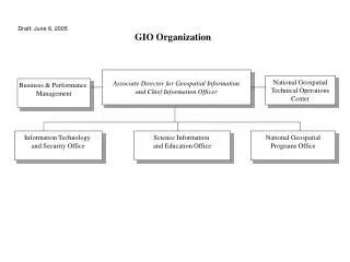
Contract Parties • OCRA • USGS • USDS • NTIA • INDOT • IN Homeland Security • MACOG • Kosciusko County • Harrison County • Bartholomew County • Woolpert Plus Ten Buy-up Contracts in 2012
Statewide Imagery Project - Ortho & LiDAR 12” Pixel Resolution: Boone Brown Carroll Cass Clinton Crawford Fulton Hendricks 6” Pixel Resolution (Buy-up): Bartholomew Elkhart Harrison Kosciusko Marion St. Joseph 2011 2013 2012 Morgan Orange Pulaski Starke Tipton Wabash Washington Howard Jackson Johnson Lawrence Marshall Miami Monroe Morgan
Statewide Imagery Project - Ortho & LiDAR 2012 2012 Buy-ups: • Allen (6-inch ortho) • Floyd (6-inch ortho & 1-meter post spacing LiDAR) • Dearborn (6-inch ortho & 1-meter post spacing LiDAR) • DeKalb (6-inch ortho) • Hamilton (6-inch ortho) • Madison (6-inch ortho & 1-meter post spacing LiDAR) • Noble (6-inch ortho) • Shelby (6-inch ortho) • Steuben (6-inch ortho) • Whitley (6-inch ortho)
Improving the NHD (National Hydrography Dataset) Purpose: To improve the accuracy and level of detail of the data about the surface waters in Indiana Streams in blue have been added to the existing NHD (red) through this project
Improving the NHD • Funding exists for the 30 sub-basin shown in green (Phase 1) • One of those, the Upper Eel, is serving as the pilot area • Phase 1 is scheduled for completion by December, 2013
IndianaMap Data Sharing Initiative 87 Current
Data Sharing Initiative Status 86 Counties have committed to share GIS data • 6,725 Jurisdictional Boundaries • 496,440 Street Centerlines Segments • 2,389,153 Address Points • 3,023,924 Land Parcels These data can be obtained from the GIO library and the IndianaMap
Broadband Mapping Wireless Wireline
State Ranking By Grant Amount(Lowest to Highest) Largest Grant: New York, $8,923,532 Average Grant: $5,541,201
Jim SparksIndiana GIO jsparks@iot.in.gov gio@iot.in.gov 317-234-5889