Download
1 / 58
690 likes | 1.37k Views
Map Projections and Datums of the Atlantic Provinces Making it Fit - or - Having a Fit by M. Donnelly & D. Raymond revised - 2002 With selected slides from Vic Dohar, Geoscience Information Division, Cartography Section, Natural Resources Canada, Ottawa. Map Projection Basics.

E N D
Map Projections and Datumsof the Atlantic ProvincesMaking it Fit - or - Having a Fitby M. Donnelly& D. Raymondrevised - 2002With selected slides from Vic Dohar, Geoscience Information Division, Cartography Section, Natural Resources Canada, Ottawa
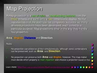
Map Projection Basics • Map projections are mathematical formulas for transforming coordinates from a three-dimensional space to a two-dimensional space. • The two-dimensional space is referenced in a Cartesian coordinate system, where feature coordinates are represented in distances measured from the X and Y axis. The origin has an X and Y value of 0, and coordinates may be represented in either positive or negative values. Projections - Making it Fit
Map Projection Basics • The purpose of a map projection is to represent features on the Earth’s surface as accurately as possible in relationship to the spatial properties of shape, area, scale and direction. • Map projections that preserve these properties are known as conformal, equal-area, equidistant and azimuthal respectively. • Some level of distortion is always present in a map projection. By definition, they are a compromise of error and distortion. Projections - Making it Fit
Projection Properties • SHAPE Conformal maps preserve local shape, • AREA Equal-area or equivalent maps retain all areas at the same scale • SCALE Equidistant maps maintain certain distances • DIRECTION Azimuthal maps express certain accurate directions. Projections - Making it Fit
SHAPE - Conformal Projections - Making it Fit
AREA - Equal-Area Projections - Making it Fit
SCALE - Equidistant Projections - Making it Fit
AZIMUTHAL - Direction Projections - Making it Fit
Map Projection Basics • The categories are: • 1) Cylindrical * • 2) Conic * • 3) Planar or azimuthal * • 4) Mathematical • * can be constructed graphically - from a sphere Projections - Making it Fit
Map Projection Basics • Cylindrical projections are conformal. • UTM and MTM are examples of cylindrical • Projections. Projections - Making it Fit
Map Projection Basics • Conic projections can be either conformal, equal-area or equidistant, depending on the complexity. Projections - Making it Fit
Map Projection Basics • Planar or Azimuthal projections display true-direction. Projections - Making it Fit
Source of ProjectionORTHOGRAPHIC Projections - Making it Fit
Source of ProjectionSTEREOGRAPHIC Projections - Making it Fit
Source of ProjectionGNOMONIC Projections - Making it Fit
Map Projection Basics • The three main projections may intersect and pass through the earth. • These are called secant projections: • 1) Secant Cylindrical 2) Secant Conic 3) Secant Planar or azimuthal Projections - Making it Fit
Map Projection Basics Secant Cylindrical projections have 2 lines of intersection Projections - Making it Fit
Map Projection Basics Secant Conic projections have 2 standard parallels Projections - Making it Fit
Map Projection Basics • Secant Planar or Azimuthal projections have • a radius of intersection from the origin. Projections - Making it Fit
Projections • Conformal Transverse Mercator, Stereographic, • Lambert Conformal Conic • Equal-Area Albers • Equidistant Equidistant Conic (Simple Conic) • Azimuthal Stereographic Projections - Making it Fit
Nova Scotia Projections: • Commonly used projections for Nova Scotia: • 1) UTM - Universal Transverse Mercator • 1:25000 (old); 1:50000; 1:250000; 1:500000 • 2) MTM - Modified Transverse Mercator • 1:1000; 1:2000; 1:5000; 1:10000 • 3) Lambert - Lambert Conformal Conic • 1:2000000 Projections - Making it Fit
Universal Transverse Mercator • Nova Scotia 6º UTM • The UTM is a world wide military mapping projection that divides the Earth into 60 zones of 6 degrees of longitude. • UTM is a secant cylindrical projection. Projections - Making it Fit
Universal Transverse Mercator Projections - Making it Fit
Northings and Eastings • The scale factors in each UTM zone varies from 0.999600 at the central meridian; values are greater than 1.0 on east and west outer portions of the zones. Projections - Making it Fit
3 - 6° UTM Zones in Nova Scotia Zone 19 Zone 20 Zone21 - 69° - 63° - 57° Universal Transverse Mercator Across Nova Scotia there are 3 UTM zones numbered 19, 20, and 21 from West to East. Only small amounts of Nova Scotia fall within zones 19 and 21. Therefore it is reasonable to “push” all of Nova Scotia into ZONE 20 with tolerable scale error. Projections - Making it Fit
Modified Transverse Mercator • Nova Scotia 3º Modified Transverse Mercator • (3º MTM) • Provincial base mapping and legal surveys are referenced to the 3º MTM projection. • The scale factors in each MTM zone varies from 0.999900 at the central meridian values greater than 1.0 on east and west outer portions of the zones. Projections - Making it Fit
Modified Transverse Mercator • 3° wide MTM Zones in Nova Scotia Zone 5 Zone 4 - 64.5° - 61.5° Across Nova Scotia there are 2 zones numbered 4 and 5 from East to West. False Easting for zone 4 is 4,500,000. False Easting for zone 5 is 5,500,000. Projections - Making it Fit
Newfoundland & Labrador 3°MTM Note that Zone 3 is calculated with the “Stephenville Shift”, CM 58°30’, to accommodate the community of Stephenville. False Easting for each Zone is 304800m. Projections - Making it Fit
New Brunswick & PEIOblique Stereographic Double Projection • This is a conformal projection selected to provide slightly higher accuracy than other solutions (i.e. MTM) • Reasonable distribution of error • Single zone solution • Secant Azimuthal Projections - Making it Fit
New Brunswick & PEIOblique Stereographic Double Projection Projections - Making it Fit
New Brunswick & PEIOblique Stereographic Double Projection Projections - Making it Fit
New Brunswick & PEIOblique Stereographic Double Projection Projections - Making it Fit
New Brunswick & PEIOblique Stereographic Double Projection New Brunswick: Origin 46°30’ N 66°30’ W False Northing 800000mN False Easting 300000mE Scale at centre of projection 0.999912 Prince Edward Island: Origin 47°15’ N 63°00’ W False Northing 400000mN False Easting 700000mE Scale at centre of projection 0.999912 Projections - Making it Fit
Datum Basics • A datum is a set of parameters defining a coordinate system, and a set of control points whose geometric relationships are known, either through measurement or calculation. All datums are based upon an ellipsoid (or spheroid), which approximates the shape of the Earth. • Required for accurate mapping at scales larger than 1:500,000 (local maps) • Smaller scale maps are derived from the Sphere Projections - Making it Fit
Spheroid Definition • • The size of a circle is defined by its radius. The size and shape of an ellipse is defined by two different radii, a semi-major and semi-minor axis. Just as rotating a circle about an axis defined by its diameter will create a sphere, rotating an ellipse about its axis will produce an ellipsoid.• An ellipsoid that approximates a sphere is called a spheroid. These two terms are used interchangeably in the literature, despite their technical differences. • • An ellipsoid used to derive coordinates for mapping purposes is sometimes called a reference ellipsoid. Projections - Making it Fit
The Reference Ellipsoid Projections - Making it Fit
Latitude & Longitude Shifts Projections - Making it Fit
Atlantic Provinces • Datums used almost exclusively in Atlantic Canada: • 1) North American Datum of 1927 (NAD27) • 2) Average Terrestrial System of 1977 (ATS77) • 3) North American Datum of 1983 (NAD83) Projections - Making it Fit
North American Datum 1927 • The North American Datum of 1927 uses the Clarke spheroid of 1866 to represent the shape of the Earth. The origin of this datum is a point on the Earth - Meades Ranch, Kansas. Many NAD27 control points were calculated from observations taken during the 1800’s. These calculations were done manually and in sections over many years, therefore errors varied from station to station and were cumulative. Projections - Making it Fit
Local Datum (NAD 27) North American Datum 1927 (NAD27) Reference point at Meades Ranch, Kansas Projections - Making it Fit
Average Terrestrial System of 1977 (ATS77) • The Maritime Provinces have used a DATUM definition called ATS77 or Average Terrestrial System. This definition was realized in 1979 and implemented by LRIS under the Council of Maritime Premiers. ATS77 was seen as an interim definition (pending release of NAD83) - much more accurate than NAD27. • This local datum has been supported only by Canadian software vendors (CARIS/USL, NSGC and FME) until recently. • The close resemblance to WGS - World Geodetic System 1972 (WGS72) permits spheroid substitution where sub-metre accuracy is not required over a large region. Projections - Making it Fit
North American Datum 1983 • Many technological advances in surveying and geodesy have revealed weaknesses in the network of control points in NAD27, particularly when linking existing control with newly established surveys. NAD83 allows for a single datum or control network to cover North America consistently, by having the origin of the datum as the Earth’s center of mass (Geocentric). • NAD83 is derived from both Earth and satellite observations and uses the GRS80 spheroid. Projections - Making it Fit
Commonly used Spheroids/Ellipsoids • Name: Semi-major Semi-minor Assoc. Projection/Datum • Sphere 6370997 6370997 Geographic • Clarke 1866 6378206.4 6356583.8 UTM(NAD27) • WGS72 1972 6378135 6356750.519915 • ATS77 1977 6378135.0 6356750.305 MTM(ATS77) • GRS80 1980 6378137 6356752.3141 UTM(NAD83) • WGS84 1984 6378137 6356752.31 GPS • Notes: • Because WGS72 and ATS77 are almost identical we can obtain sub-metre accuracy using WGS72 for ATS77. In software packages not supporting ATS77, this is the only* option. Projections - Making it Fit
Earth-Centred Ellipsoid vs. Local Datum Projections - Making it Fit
Know your data • Understanding the coordinate system defined in NTS data is critical in geo-referencing and overlaying thematic data. Geomatics Canada includes a header file that defines the coordinate system of NTS data. The following example lists NTS data in NAD83 on the UTM projection: • The North American Datum of 1983 (NAD83) is used as the reference system for the planimetric coordinates (X,Y) of NTDB entities. • The coordinates are projected on the Universal Transverse Mercator (UTM) grid, which is based on the GRS80 reference ellipsoid. • Elevations are expressed in reference to mean sea level (Canadian Vertical Geodetic Datum). Projections - Making it Fit
Datum Transformations • Datum transformations are defined shifts in latitude and longitude values at specific points on the Earth’s surface. Transformations exist between NAD27, ATS77 and NAD83. • CAUTION: Significant errors can result when attempting to convert one datum to another if no official transformation exists between them. Even though your software will allow it, the results will be incorrect. Projections - Making it Fit
Datum Transformations • A datum transformation alters two things: • 1) The location of longitude and latitude lines, • due to the change in reference ellipsoid • 2) The shift in features due to different datums Projections - Making it Fit
Datum Transformations Projections - Making it Fit
Datum Transformations Projections - Making it Fit