Download
1 / 1
10 likes | 25 Views
Geophysical Habitat Mapping. Falmouth 2012 Group 2: Hazel Aslin , Carlo Bella, Marina Brassington , Clair Caldwell, Michael Hughes, Sarah Lane, Federico Pastorelli , Julie Seager -Smith , Georgina Selwyn, Ben Smith. Aims. 1. Introduction.

E N D
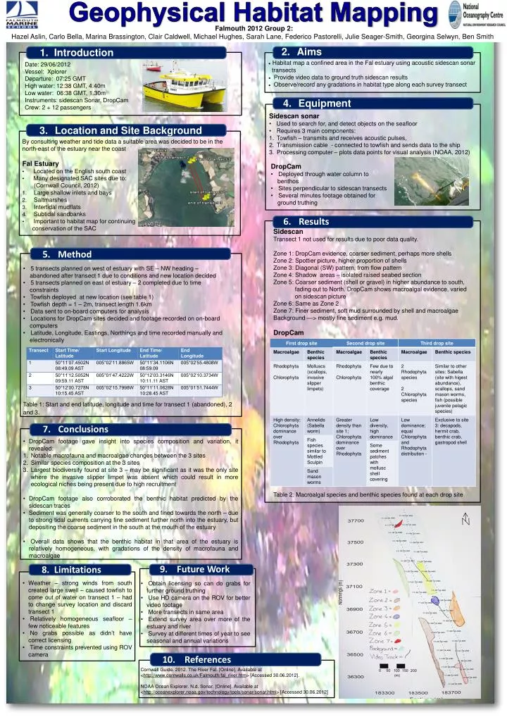
Geophysical Habitat Mapping • Falmouth 2012 Group 2: • Hazel Aslin, Carlo Bella, Marina Brassington, Clair Caldwell, Michael Hughes, Sarah Lane, Federico Pastorelli, Julie Seager-Smith, Georgina Selwyn, Ben Smith Aims 1. Introduction • Habitat map a confined area in the Fal estuary using acoustic sidescansonar • transects • Provide video data to ground truth sidescan results • Observe/record any gradations in habitat type along each survey transect • Date: 29/06/2012 • Vessel: Xplorer • Departure: 07:25 GMT • High water: 12:38 GMT, 4.40m • Low water: 06:38 GMT, 1.30m • Instruments: sidescan Sonar, DropCam • Crew: 2 + 12 passengers Equipment • Sidescan sonar • Used to search for, and detect objects on the seafloor • Requires 3 main components: • Towfish – transmits and receives acoustic pulses, • Transmission cable - connected to towfish and sends data to the ship • Processing computer – plots data points for visual analysis (NOAA, 2012) Location and Site Background • By consulting weather and tide data a suitable area was decided to be in the north-east of the estuary near the coast • Fal Estuary • Located on the English south coast • Many designated SAC sites due to: • (Cornwall Council, 2012) • Large shallow inlets and bays • Saltmarshes • Intertidal mudflats • Subtidalsandbanks • Important to habitat map for continuing • conservation of the SAC • DropCam • Deployed through water column to • benthos • Sites perpendicular to sidescan transects • Several minutes footage obtained for • ground truthing Results • Sidescan • Transect 1 not used for results due to poor data quality. • Zone 1: DropCam evidence, coarser sediment, perhaps more shells • Zone 2: Spottier picture, higher proportion of shells • Zone 3: Diagonal (SW) pattern, from flow pattern • Zone 4: Shadow areas – isolated raised seabed section • Zone 5: Coarser sediment (shell or gravel) in higher abundance to south, • fading out to North. DropCam shows macroalgal evidence, varied • on sidescan picture • Zone 6: Same as Zone 2 • Zone 7: Finer sediment, soft mud surrounded by shell and macroalgae • Background —> mostly fine sediment e.g. mud. • DropCam • Table 2: Macroalgal species and benthic species found at each drop site Method • 5 transects planned on west of estuary with SE – NW heading – • abandoned after transect 1 due to conditions and new location decided • 5 transects planned on east of estuary– 2 completed due to time • constraints • Towfish deployed at new location (see table 1) • Towfish depth = 1 – 2m, transect length 1.6km • Data sent to on-board computers for analysis • Locations for DropCam sites decided and footage recorded on on-board • computers • Latitude, Longitude, Eastings, Northings and time recorded manually and • electronically • Table 1: Start and end latitude, longitude and time for transect 1 (abandoned), 2 and 3. 8. Limitations 10. References 9. Future Work Conclusions • DropCam footage gave insight into species composition and variation, it revealed: • Notable macrofauna and macroalgae changes between the 3 sites • Similar species composition at the 3 sites • Largest biodiversity found at site 3 – may be significant as it was the only site where the invasive slipper limpet was absent which could result in more ecological niches being present due to high recruitment • DropCam footage also corroborated the benthic habitat predicted by the sidescan traces • Sediment was generally coarser to the south and fined towards the north – due to strong tidal currents carrying fine sediment further north into the estuary, but depositing the coarse sediment in the south at the mouth of the estuary • Overall data shows that the benthic habitat in that area of the estuary is relatively homogeneous, with gradations of the density of macrofauna and macroalgae • Weather – strong winds from south created large swell – caused towfish to come out of water on transect 1 – had to change survey location and discard transect 1 • Relatively homogeneous seafloor – few noticeable features • No grabs possible as didn’t have correct licensing • Time constraints prevented using ROV camera • Obtain licensing so can do grabs for further ground truthing • Use HD camera on the ROV for better video footage • More transects in same area • Extend survey area over more of the estuary and river • Survey at different times of year to see seasonal and annual variations Cornwall Guide. 2012. The River Fal. [Online]. Available at <http://www.cornwalls.co.uk/Falmouth/fal_river.htm> [Accessed 30.06.2012]. NOAA Ocean Explorer. N.d. Sonar. [Online]. Available at <http://oceanexplorer.noaa.gov/technology/tools/sonar/sonar.html> [Accessed 30.06.2012]