Download
1 / 31
310 likes | 545 Views
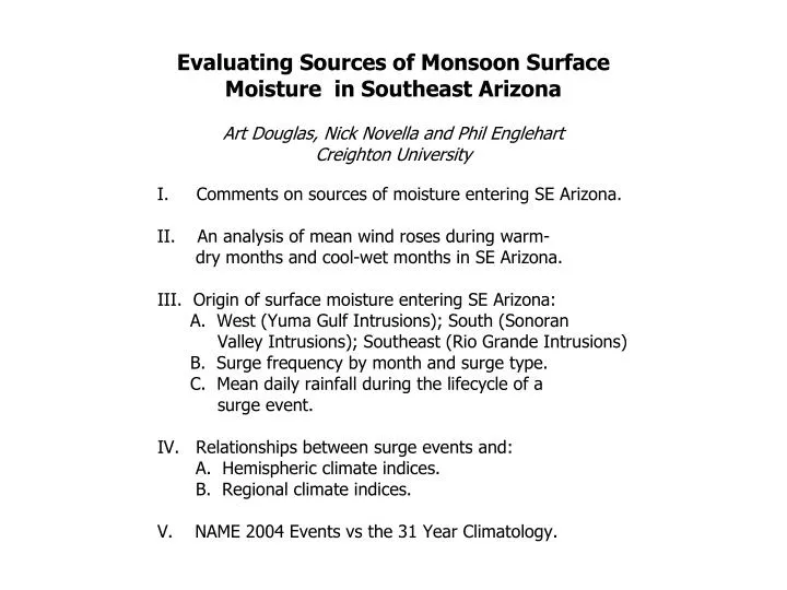
GAP TOPOGRAPHY. SEEPAGE/SURGE TYPES. FT. HUACHUCA, AZ PROFILER 08-July-2002. Douglas AZ dewpoint temperature 07-08 July 2002. II. An analysis of mean wind roses during warm- dry months and cool-wet months in SE Arizona. WIND ROSE FOR DOUGLAS, AZ July-August (1973-2002). GMT.

E N D
FT. HUACHUCA, AZ PROFILER 08-July-2002
Douglas AZ dewpoint temperature 07-08 July 2002
II. An analysis of mean wind roses during warm- dry months and cool-wet months in SE Arizona.
WIND ROSE FOR DOUGLAS, AZ July-August (1973-2002) GMT
DOUGLAS, AZ: CONTRASTING SURFACE WINDS (Jul-Aug) WARM/DRY COOL/WET 25.3ºC / 113mm 27.3ºC / 47mm
July SLP anomalies (Cool/Wet - Warm/Dry)
July 700mb Hgt. anomalies (Cool/Wet - Warm/Dry)
III. Origin of surface moisture entering SE Arizona: A. West (Yuma Gulf Intrusions); South (Sonoran Valley Intrusions); Southeast (Rio Grande Intrusions) B. Surge frequency by month and surge type. C. Mean daily rainfall during the lifecycle of a surge event.
High dew point days at Douglas can arise from any one or combination of the following: 1. Air mass moistening from a local rainfall event. 2. Mesoscale outflow boundaries arriving at the site. 3. Intensification of surface moisture advection under a strengthening SLP gradient. 4. Large scale synoptic forcing/moistening related to an approaching easterly wave, tropical cyclone or back door cold front. Question: How are these events related to local and synoptic scale forcing?
IV. Relationships between surge events and: A. Hemispheric climate indices B. Regional climate indices.
LARGE-SCALE CLIMATE INDICES (700 mb.)
July Surge TYPE 3 (RIO GRANDE) vs. Regional Climate Indices
August Surge TYPE 3 (RIO GRANDE) vs. Regional Climate Indices
September Surge TYPE 3 (RIO GRANDE) vs. Regional Climate Indices
Jul-Sept Surge TYPE 1 (YUMA) vs. Regional Climate Indices
Jul-Sept Surge TYPE 2 (SONORAN VALLEY) vs. Regional Climate Indices
Summer 2004 Climate Indices Expected to Influence the Frequencyof SE Arizona Seepage/Surge Events