Download
1 / 29
290 likes | 401 Views
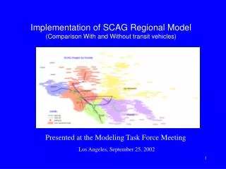
Task 5: Lounaispaikka Regional GI Service. Advancements 1.10.2004-31.3.2005 Lasse Nurmi, Cooperation Coordinator, Regional Council of Southwest Finland ENVIFACILITATE project meeting 13.4.2005. 1. Establishing a data archive for environmental data sets

E N D
Task 5:Lounaispaikka Regional GI Service Advancements 1.10.2004-31.3.2005 Lasse Nurmi, Cooperation Coordinator, Regional Council of Southwest Finland ENVIFACILITATE project meeting 13.4.2005
1. Establishing a data archive for environmental data sets 2. Expanding Archipelago Sea Map service thematically and geographically 3. Linking species data to environmental information Actions in Task 5
4. Enhancing the facility and regional collaboration * Developing operational applications for environmentally sensitive land use planning (Land Use Plan Atlas) (in task 6) Actions in Task 5
The GI data archive was officially established in January Juridically part of UTU Maintained by the Dept. of Geography A part of the Lounaispaikka Data Service Model 1. Establishing a data archive for enviromental data sets
Created mainly for archival of environmental data which is - not produced commercially - without a distribution channel - in danger to get vanished after primary use 1. Establishing a data archive for enviromental data sets
Main focus in the GI data which is produced in fixed-period projects The archive is ready to be used, but some small modifications and definitions will still have to be made 1. Establishing a data archive for enviromental data sets
ASM was originally produced in Life COASTRA –project and after the project ended the service is developed further in ENVIFACILITATE The service contains information from four major themes: nature, cultural features, infrastructure and sources of livelihood 2. Expanding Archipelago Sea Map service thematically and geographically
During spring 2005 a new theme was added to ASM: aerial photos Photos are produced by the Topographical Service of Finnish Army The photos are mainly from years 1993, 1995 and 1999 and cover most of the coastal and archipelago area of SW Finland region. 2. Expanding Archipelago Sea Map service thematically
2. Expanding Archipelago Sea Map service thematically New aerial photos make interesting comparisons between interpreted and photographed data possible
There have been discussions about expanding the geographical area of ASM to the area of Western Uusimaa. The expansion would be made in liaison with another regional GI center project in Ekenäs. This is still under discussion. 2. Expanding Archipelago Sea Map service geographically
Discussions about combining research metadata to ASM have been made The metadata is collected by the Meriluonto project and the project has made test maps of the data to a map service. Meriluonto is a part of VELMU programme (Finnish Inventory Programme for the Underwater Marine Environment) 2. Expanding Archipelago Sea Map service geographically
Most of the aggreements of AMS were connected with Life COASTRA and therefore were valid until the end of year 2004 During spring 2005 the agreements are going to be renewed (new agreements with SYKE are already in force ) 2. Other advancements in Arcipelago Sea Map
2. Other advancements in Arcipelago Sea Map An english version of ASM is also now available.
Info- and discussion meeting was arranged by UTU and RCSW to find out what kind of activity there is in SW Finland concerning species data. Two potential conncetions were found: The Ornithological Society of Turku Åbo Akademi Department of Biology 3. Linking species data to environmental information
The Ornithological Society of Turku observational records since the 1960’s over 350 000 observations in the data base semi-precise location information (names of places) a web-based tool for members of the society to enter individual observations, but no map interface to locate observations more precisely 3. Linking species data to environmental information
A proposal for The Ornithological Society of Turku a map interface to be attached to the observation reporting tool to get more accurate location info the base map for the interface (and probably for ASM, too) automatically transferred from a decentralized source (such as Karttapaikka provided by the NLS) using wms-interface – always up-to-date 3. Linking species data to environmental information
A proposal for The Ornithological Society of Turku old observations located as accurately as possible thematic maps created from the observational data of the society and published through ASM. 3. Linking species data to environmental information
Åbo Akademi Dept. of Biology Floral GI data base from the area of Archipelago Sea Complete species lists from hundreds of islands within the area. Data from the 1960’s and 1990’s – thematic maps could be created for example of the change of biodiversity The discussions about cooperation will be started during April 3. Linking species data to environmental information
Basic activities as usual Paikkatietomarkkinat 2005 (5.-6.10.) fair, Helsinki. Lounaispaikka-stand. Cross-regional GI cooperation with a regional GI centre project in Western Uusimaa (Southwest Polytechnic Ekenäs) established Paikkatietopäivä 2005 seminar (30.11.) arranged by Lounaispaikka in Turku. 4. Enhancing the facility and regional collaboration
A survey concerning regional GI usage and production together with UTU and the city of Turku GI cooperation project Planning of the survey (January-March) The realization of the survey (April-June) Analysis (during summer) Reporting (early fall) and an article about the results 4. Enhancing the facility and regional collaboration
Regional GI education course with an apprenticeship contract an info meeting arranged for interested regional GI users the course will be started in autumn by Further Education College Tavastia and the arrangements will be done by Lounaispaikka 4. Enhancing the facility and regional collaboration
Pilot version of the service was created in 2002-2003 by a project funded by ERDF’s InnoELLI innovative actions programme In autumn 2004 a new project ”Further development of SW Finland Regional Land Use Plan Atlas and the development of a regional map service for pipelines” was launched Developing operational applications for environmentally sensitive land use planning (Land Use Plan Atlas)
Basic idea of the service is to support better land use planning by showing land use plans over municipality borders and different planning levels in same service The project partners are RCSW, City of Turku and the Regional Environment Centre of SW Finland The data in the service is from the municipalities and the regional council Land Use Plan Atlas
What’s new: Plans of different planning levels have not previously been put in same service – comparisons between the plans can be easily made Due to the larger overall view, planning can be more sensible: splinterness, decreasing biodiversity, can be reduced a network of unbroken green corridors can be made Land Use Plan Atlas
Now: New Master Plans have been attached to the service during spring A test version of new thematic area, fresh and waste water pipelines is going to be published by the end of the year A preliminary plan of an interactive web-based participation tool is under development – the tool makes it possible for citizens to participate in land use planning during the planning process over the web. Land Use Plan Atlas