Download
1 / 17
170 likes | 833 Views
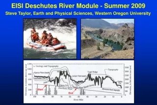
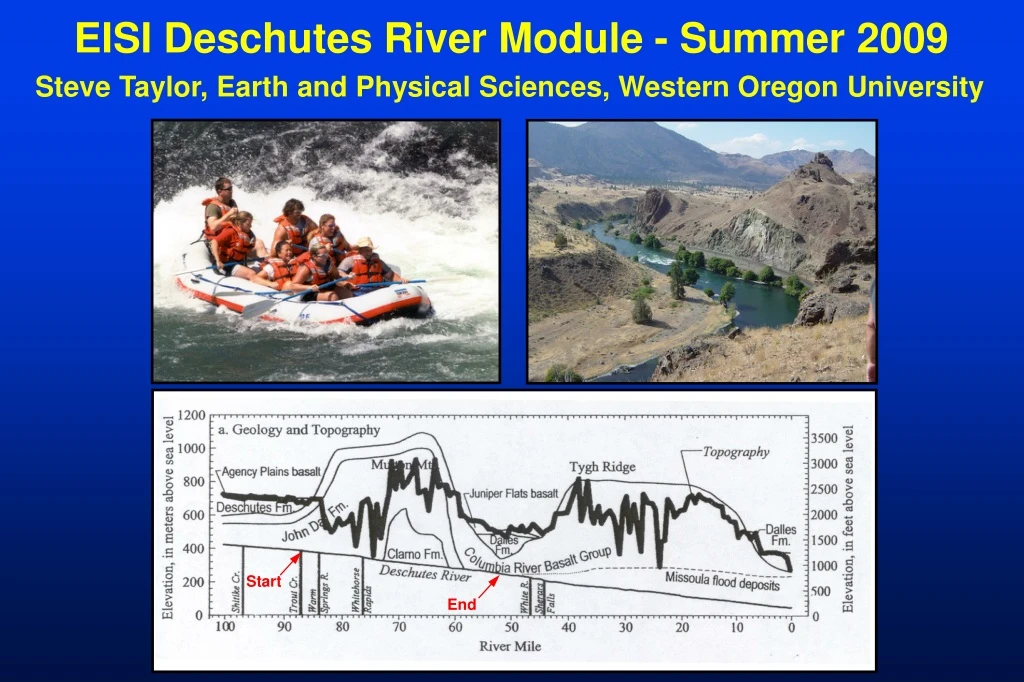
Start. End. EISI Deschutes River Module - Summer 2009. Steve Taylor, Earth and Physical Sciences, Western Oregon University. LEARNING OBJECTIVES. To engage team building in the context of outdoor adventure and experiential education To acquire knowledge of the regional geologic,

E N D
Start End EISI Deschutes River Module - Summer 2009 Steve Taylor, Earth and Physical Sciences, Western Oregon University
LEARNING OBJECTIVES • To engage team building in the context of outdoor • adventure and experiential education • To acquire knowledge of the regional geologic, • hydrologic, and geomorphic setting of western • Oregon • To apply spatial and temporal scaling concepts to • watershed systems • To develop skills in field-based observation, data • collection, analysis, and hypothesis testing • To gain experience with techniques of landscape • analysis and interpretation of the geologic record
Cascade Range Ochoco Mtns To HJA EISI Float Location of dams • Ad = 26,860 sq. km • N-S length ~ 300 km • 3 hydroelectric dams • John Day Basin to east • Cascades to west • Geology • John Day and Clarno Forma- • tions (55-20 m.y. old) • Columbia River Basalts • (17-14 m.y.) • Deschutes Fm volcanics • (10-2 m.y.) • Pleistocene and Holocene surficial deposits (< 1 m.y.) • Avg. rainfall < 1000 mm • Semi-Arid • Avg. Runoff = 0.19 m • Q range: 124-213 cms
Pacific Northwest Climate and Tectonics:Linked System Drivers “Wet” “Dry” Westerly cyclonic storm systems Deschutes High Cascades Western Cascades HJA
Field Trip Content • Regional physiography of Cascades and central Oregon • Geology, geomorphology and hydrology of Deschutes Basin • Introduction to geologic observation and landscape analysis • Fundamental principles of hydrology and geomorphology • Fundamentals of fisheries, riparian habitat, watershed • assessment, and river restoration Participant Deliverables And Assessment • Pre-trip reading questions • Active learning assignments • Post-trip reflection paper • Smiles, laughter, fun, friends, adventurous stories to tell
LOGISTICS • Travel HJA to Trout Creek, Sunday, June 21, PM • 3 nights camping; 2.5 days rafting, ~55 river miles • Field support: river guides, paddle boats, bag boats • Food: 3-a-day provided except for Trout Ck. Camp • Camp kitchen and staff cooks provided • Extra group coolers, snacks, specialty items = CYA • Personal gear stowed in dry bags / on bag boats • Tent teams encouraged • Dry and sunny, rain possible, cold water, WIND • Prepare for sunburn, dehydration, prickly vegetation • Other stuff: water shoes / river sandals, sleeping bag, • sleeping pad, tent, flashlight, closed shoes for hiking, • swimming / fly fishing, towel, soap/shampoo, river baths
INTRODUCTION TO WATERSHEDS AND RIVERS Energy Sources in the Fluvial System Gravitational Solar (Climate) Geothermal (Tectonics) Work of the Fluvial System Transfer of Energy Transfer of Mass Water Sediment Rafting People
The physical work of rivers: transport sediment and water Ecological services and riparian habitat (Tectonics)
“Hey Taylor – note to self…now’s the time to show the video clip illustrating hillslope-valley bottom process-response mechanisms and the interaction between variables, including human impacts from geomorphic change…” And now a message from our sponsor: kayakingsucks.com
…increasing the scale of this example… Columbia River Gorge: Bridge of the Gods Landslide Complex -Blocked river ca. 300 yrs ago -Legacy effects on landscape
Hillslope Regime Valley-Bottom Regime Landscape Analysis: Landform, Material, Process, Age The record of past processes and tapestry of time… Material: Sedimentary Bedrock (Age = 20 m.y.) Fault Process: Anthropogenic Process: Colluvial Transport Process: Alluvial Transport Material: Igneous Bedrock (Age = 100 m.y.) Material: Gravel (Age = 2000 yr) Material: Unconsolidated Sandy Gravel (Age = last winter) Material: Angular Cobbles (Age = 10,000 yr)
Age of landscape features and rates of processes: the most elusive facets of study. Geologically Relevant Time Scales: 10-5 to 109 Years (minutes-hours-days-years-thousands-hundreds of thousands-millions-billions of years) Engineering Time Scales? 100 to 102 yrs (then build another one…) Age of Landforms (Surfaces) River Terrace Age of Deposits (Terrace Deposits) How long since these gravels were last transported by channel processes?
Synergistic extension to Eco-Informatics work at HJ Andrews Experimental Forest, “the home of long-term watershed research in the Pacific Northwest”?… 2009 EISI campers, academic enlightenment is knocking at your door, seize the moment!