Download
1 / 11
170 likes | 954 Views
Using your compass-clinometer. Taking a bearing of a rock feature - e.g. strike Measuring the inclination (e.g. dip). Parts. “baseplate”. rim. “side”. black arrow = clinometer. Read bearing here. Scale for clino -use set 090 - 270. Outline arrow - Rotate to find bearing.

E N D
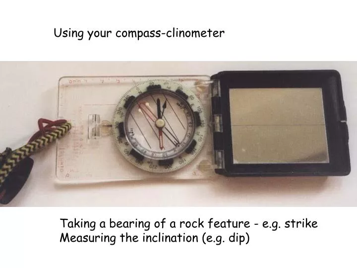
Using your compass-clinometer Taking a bearing of a rock feature - e.g. strike Measuring the inclination (e.g. dip)
Parts “baseplate” rim “side” black arrow = clinometer Read bearing here Scale for clino -use set 090 - 270 Outline arrow - Rotate to find bearing Magnetic needle points N-S
To measure the direction of the arrow Align the side of the compass with the line
Read off the bearing (value 000 to 360) ALWAYS KEEP BASE -PLATE HORIZONTAL WHEN MEASURING BEARINGS 264 Rotate the rim so that the red arrow matches over the magnetic north arrow
To measure the inclination - set up the compass-clinometer as a CLINOMETER Set rim to lie 090-270 Ignore the magnetic needle!
To measure the inclination - set up the compass-clinometer as a CLINOMETER We will use this scale to measure inclination
READ OFF VALUE - using black arrow 28 Place side of compass against object MAKE SURE THE COMPASS “PLATE” IS VERTICAL
Using your compass-clinometer Taking a bearing of a rock feature - Measuring the inclination ALWAYS HORIZONTAL ALWAYS VERTICAL
This rotates outline arrow away from zero - either CW or ACW. Check maps for info. Using your compass-clinometer As described - bearing are always relative to MAGNETIC North To relate to TRUE N or GRID N we must adjust the DECLINATION (small screw on back of compass)
Example from OS map Shows here that GRID N is CW of MAG N Shows actual amount and its predicted variation into future from date of map
Using your compass-clinometer Taking a bearing of a rock feature - e.g. strike Declination correction Measuring the inclination (e.g. dip)