Download
1 / 29
290 likes | 657 Views
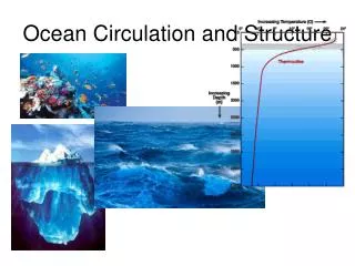
Unit 7: Ocean Currents (Chapter 9 Circulation of the Ocean). Circulation of the Ocean. The ocean is on the move. The horizontal drift of ships and the vertical movement of cold water are caused by currents. Current is the mass flow of water. What are some effects of ocean currents?.

E N D
Circulation of the Ocean • The ocean is on the move. • The horizontal drift of ships and the vertical movement of cold water are caused by currents. • Current is the mass flow of water
What are some effects of ocean currents? • Transfer heat from tropical to polar regions • Influence weather and climate • Distribute nutrients and scatter organisms
Ocean Currents • Surface currents are wind-driven movements of water at or near the ocean’s surface. • Thermohaline currents are the slow, deep currents that affect the bulk of seawater beneath the pycnocline.
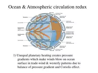
Mass flow of Ocean water is driven by wind and gravity • A combination of four forces circulates the ocean surface clockwise in the Northern hemisphere and counter clockwise in the Southern Hemisphere, forming gyres • Surface winds • Sun’s heat • Coriolis effect • gravity
What causes surface currents? • Primary force is wind. • Most: the easterlies and westerlies. • Waves also. • The water flowing beneath the wind forms a surface current.
Surface Currents • About 10% of the water in the world ocean is involved in surface currents, water flowing horizontally in the uppermost 400 meters (1,300 feet) of the ocean’s surface.
This flow around the periphery of an ocean basin is called a Gyre Surface Currents Flow around the Periphery of Ocean Basins
Elkman Spiral • Because of the Coriolis effect, the surface layer drifts at a 45 degree angle • The water moves in horizontal movements in a layered water column. • Looks similar to a spiral
Geostrophic Gyres • Gyres in balance between the pressure gradient and the Coriolis effect are called Geostrophic Gyres. • They are largely independent of one another in each hemisphere because of patterns of driving winds and the present positions of continents.
Seawater Flows in Six Great Surface Circuits • Five are geostrophic gyres: North Atlantic gyre, South Atlantic gyre, the North Pacific gyre, the South Pacific gyre, and the Indian Ocean gyre. • The sixth and largest current is not a gyre because it does not flow around a periphery of an ocean basin. The West Wind Drift flows endlessly eastward around Antarctica, driven by westerly winds.
Boundary Currents Have Different Characteristics What currents are found within gyres? Western boundary currents –These are narrow, deep, fast currents found at the western boundaries of ocean basins. • The Gulf Stream (largest) • The Japan Current • The Brazil Current • The Agulhas Current • The Eastern Australian Current
Boundary Currents Have Different Characteristics Eastern boundary currents –These currents are cold, shallow and broad, and their boundaries are not well defined. The Canary Current The Benguela Current The California Current The West Australian Current The Peru Current
Boundary Currents Have Different Characteristics Eddy formation The western boundary of the Gulf Stream is usually distinct, marked by abrupt changes in water temperature, speed, and direction. (a) Meanders (eddies) form at this boundary as the Gulf Stream leaves the U.S. coast at Cape Hatteras. The meanders can pinch off (b) and eventually become isolated cells of warm water between the Gulf Stream and the coast (c). Likewise, cold cells can pinch off and become entrained in the Gulf Stream itself (d). (C = cold water, W = warm water; blue = cold, red = warm.)
Boundary Currents Have Different Characteristics Water flow in the Gulf Stream and the Canary Current, parts of the North Atlantic gyre.
Surface Currents Affect Weather and Climate General summer air circulation patterns of the east and west coasts of the United States. Warm ocean currents are shown in red; cold currents, in blue. Air is chilled as it approaches the west coast and warmed as it approaches the east coast.
Surface Currents Affect Weather and Climate Wind induced vertical circulation is vertical movement induced by wind-driven horizontal movement of water. Upwelling is the upward motion of water. This motion brings cold, nutrient rich water towards the surface. Downwelling is downward motion of water. It supplies the deeper ocean with dissolved gases.
Nutrient-Rich Water Rises near the Equator Equatorial upwelling. The South Equatorial Current, especially in the Pacific, straddles the geographical equator. Water north of the equator veers to the right (northward), and water to the south veers to the left (southward). Surface water therefore diverges, causing upwelling. Most of the upwelled water comes from the area above the equatorial undercurrent, at depths of 100 meters or less.
Wind Can Induce Upwelling near Coasts Coastal upwelling. In the Northern Hemisphere, coastal upwelling can be caused by winds from the north blowing along the west coast of a ccontinent. Water moved offshore by Ekman transport is replaced by cold, deep, nutriend-laden water. In this diagram, temperature of the ocean surface is shown in degrees Celsius.
Wind Can Also Induce Upwelling Coastal Downwelling Coastal downwelling. Wind blowing from the south along a Northern Hemisphere west coast for a prolonged period can result in downwelling. Areas of downwelling are often low in nutrients and therefore relatively low in biological productivity.
El Niño and La Niña Are Exceptions to Normal Wind and Current Flow In an El Niño year, when the Southern Oscillation develops, the trade winds diminish and then reverse, leading to an eastward movement of warm water along the equator. The surface waters of the central and eastern Pacific become warmer, and storms over land may increase. In a non-El Niño year, normally the air and surface water flow westward, the thermocline rises, and upwelling of cold water occurs along the west coast of Central and South America. An El Niño Year A Non-El Niño Year
L H 180º 0 200 m Moist air rises Rainfall Surface winds Warm-water pool Thermocline Upwelling Stepped Art Fig. 9-19a, p. 249
Thermohaline Circulation Affects All the Ocean’s Water The movement of water due to different densities is thermohaline circulation. Remember that the ocean is density stratified, with the densest water at the bottom. There are five common water masses: • Surface water • Central water • Intermediate water • Deep water • Bottom water
Thermohaline Flow and Surface Flow: The Global Heat Connection The global pattern of deep circulation resembles a vast “conveyor belt” that carries surface water to the depths and back again. Begin with the formation of North Atlantic Deep Water north of iceland. This water mass flows south through the Atlantic and then flows over (and mixes with) deep water formed near Antarctica. The combined mass circumnavigates Antarctica and then moves north into the Indian and Pacific ocean basins. Diffuse upwelling in all of the ocean returns some of this water to the surface. Water in the conveyor gradually warms and mixes upward to be returned to the North Atlantic by surface circulation. The whole slow-moving system is important in transporting water and heat.
(right) A model of thermocline circulation caused by heating in lower latitudes and cooling in higher latitudes. The thermocline at middle and low latitudes is “held up” by the slow upward movement of cold water. (left) The water layers and deep circulation of the Atlantic Ocean. Arrows indicate the direction of water movement. Convergence zones are areas where water masses approach one another. Water Masses May Converge, Fall, Travel across the Seabed, and Slowly Rise