Download
1 / 17
170 likes | 354 Views
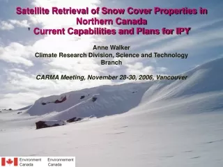
Snow Water Equivalent Variations in Western Canada – Climate Change Related Impacts for Hydropower Production. Anne Walker Climate Research Branch, Meteorological Service of Canada PERD CCIES Workshop January 22-24, 2003. Importance of Snow Cover for Hydropower Applications.

E N D
Snow Water Equivalent Variations in Western Canada – Climate Change Related Impacts for Hydropower Production Anne Walker Climate Research Branch, Meteorological Service of Canada PERD CCIES Workshop January 22-24, 2003
Importance of Snow Cover for Hydropower Applications • Seasonal snow cover is a dominant feature of the Canadian landscape for a large part of the year • Snow cover is a major source of water in the hydrologic cycle for northern climates such as Canada • knowledge of the water equivalent of the snow cover (SWE) over a basin during a winter season is one of the most important pieces of information for management of hydropower facilities • snow cover is closely tied to air temperature and precipitation • changes in these climate variables will have a direct impact on SWE amounts and distribution • understanding of recent variations/changes in snow cover (SWE) and related impacts on hydropower production is necessary to be able to predict the future impacts on the hydroelectric industry due to climate-related changes in snow cover
PERD SWE Project Objectives (1) to create a 20-year time series (1979-1999) of satellite-derived snow water equivalent (SWE) over selected basins in western Canada that are of key importance to hydropower production (2) analyse the spatial and temporal variations in snow water equivalent depicted in the time series and determine the vulnerability of hydropower facilities during the 20 year period to provide a baseline for future expected changes (3) using future climate scenarios based on output from the Canadian global climate model (GCM) and/or other GCM’s, develop scenarios of change in SWE and assess the expected impacts of these changes on hydropower operations over the next 50-100 years (4) conduct a preliminary assessment of the feasibility of incorporating satellite derived SWE into regional climate models
Cryosphere in the Climate System CRB/MSC research theme focussed on understanding the role of the cryosphere in the climate system • Conducting studies on the spatial and temporal variability of cryospheric elements using both conventional and satellite data sets and relationships with climate variability. • Development, validation and implementation of new techniques to use remote sensing for the measurement of cryospheric and other climate variables. • Optical and microwave satellite data (e.g., AVHRR, SSM/I) • Airborne, ground-based microwave radiometers
Passive Microwave Satellite Remote Sensing for Snow Cover • scattering of emitted earth radiation by snow cover provides basis for SWE/depth retrieval, areal snow extent • SSM/I – coverage of large regions in Canada at least 2X daily • Day and night sensing; spatial resolution = 25 km • Improved spatial and temporal coverage over conventional measurements • Near real-time access to data (via CMC) provides capability to support operational applications • 20+ year data record with SSM/I (1987-present) + SMMR (1978-87) suitable for analyses of temporal variability (climate research applications) Example of DMSP SSM/I satellite coverage over North America in one day. MSC conventional networks - snow
CRB/MSC Passive Microwave Snow Cover Research Main objective: • develop, validate and refine empirical and theoretical algorithms of snow cover properties in varying climatic regions and landscapes of Canada using passive microwave data • focus on SWE algorithm development and validation • satellite, airborne and ground-based radiometers • field campaigns • information products for operational agencies (e.g. flood forecasting, hydro-power, weather prediction) • collaboration with university research partners (CRYSYS) Study sites: [1] Southern Prairies (agricultural) [2] Boreal Forest (forest) [3] Mackenzie Basin (forest, tundra) [4] Central Quebec (taiga) [5] New Brunswick (dense forest) [6] Southern Ontario (agricultural, forest) [7] [8] Arctic Islands (tundra)
Passive Microwave SWE Algorithms • Prairie (open) algorithm • SWE algorithm developed using airborne microwave radiometer data set (1982 experiment) • weekly SWE maps produced using SSM/I data since 1989 SWE = a + b (TB37V - TB19V) 18 • Boreal forest algorithms • 3 forest SWE algorithms derived using BOREAS airborne microwave radiometer data, ground SWE data • coniferous, deciduous, sparse forest • 4 algorithms applied to gridded SSM/I data with addition of land cover classification data to yield an overall SWE value that takes into account effects of land cover variations SWE = FDSWED + FCSWEC + FSSWES + FOSWEO D - deciduous; C - conifer, S - sparse forest, O - open SWEi = A + B (37V - 19V) Fi = Land cover fraction per grid point (i = D, C, S or O)
Regional SWE Monitoring – Canadian Prairies SSM/I SWE Map for January 22, 2003 • Operational products generated using prairie and boreal forest SWE algorithms • Weekly SWE maps for 3 prairie provinces • Products available to public via internet – State of the Canadian Cryosphere website (www.socc.ca) • Products distributed via e-mail to a variety of users: • Federal government: MSC, Water Survey of Canada, Agriculture Canada, Canadian Wheat Board • Provincial government: Alberta Environment, Manitoba Conservation, BC Environment, Lands and Parks • Hydroelectric companies: Manitoba Hydro, NWT Power Corporation, BC Hydro • Other users: Red River Basin Disaster Information Network, Lake of the Woods Control Board, Electric Power Group (New York, USA), Private citizens (for recreation, tourism)
Specialized SWE Products for Hydropower Applications Manitoba Hydro receives weekly SWE maps (Canadian prairie region and Manitoba focus) Used in making reservoir operating decisions (input to weekly water planning meetings) Weekly SWE maps for the Snare River basin are produced before and during spring melt for NWT Power Corporation for use in planning hydroelectric power operations Snare River Basin – NWT Relationships with hydropower clients have already been established through operational SWE products – introduction of satellite derived products into their operational activities
PERD SWE Project Objectives – Progress to Date (1) to create a 20-year time series (1979-1999) of satellite-derived snow water equivalent over selected basins in western Canada that are of key importance to hydropower production (2) analyse the spatial and temporal variations in snow water equivalent depicted in the time seriesand determine the vulnerability of hydropower facilities during the 20 year period to provide a baseline for future expected changes (3) using future climate scenarios based on output from the Canadian global climate model (GCM) and/or other GCM’s, develop scenarios of change in SWE and assess the expected impacts of these changes on hydropower operations over the next 50-100 years (4) conduct a preliminary assessment of the feasibility of incorporating satellite derived SWE into regional climate models
Objective 1: Creation of SWE Time Series • Need to understand spatial and temporal variations in snow cover and relationships to climate • Availability of SSM/I and SMMR data in a consistent 25 km grid format (EASE-Grid) • temporal coverage: October 1978 to December 2001 • Opportunity to look at spatial and temporal variations in snow cover over 20+ years and relate to climate/atmospheric circulation • Can we safely combine SMMR and SSM/I records, apply current algorithms and be certain that resulting trends are real or related to sensor differences? • SMMR-SSM/I continuity issues were identified after applying SWE algorithms to passive microwave time series • Focus of research by PDF at CRB (Dr. Chris Derksen – expertise in snow-climate interactions)
SMMR SSM/I Discontinuity in SWE Time Series • SMMR period dominated by lower snow-covered area (SCA) and SWE in comparison with SSM/I time period. • Is this “real” or the result of SWE algorithm performance w.r.t. differences between the two EASE-Grid data products?
* * * * * * * Comparisons with in-situ Data SMMR derived SWE estimates are consistently too low relative to surface data. Bias not observed with SSM/I derived SWE estimates, indicating systematic SWE underestimation during SMMR years.
Removal of Sensor Bias in SWE Time Series • SMMR and SSM/I brightness temperature regressed during overlap period for midlatitude terrestrial study area. • SMMR18V = 0.936▪SSM/I19V + 8.24 • SMMR37V = 0.900▪SSM/I37V + 21.89 • Subsequently, all SMMR brightness temperatures adjusted to the SSM/I F-8 baseline, and SWE reprocessed. Before Adjustment After Adjustment
Evaluation of AdjustedSWETimeSeries • Evaluation indicates this adjusted dataset is suitable for time series analysis:
PC1PC2 + - + - + - + - 15.1% 4.4% PC3PC4 3.7% 4.0% Objective 2: Analysis of SWE Variability Rotated principal components analysis (1978/79 – 2000/01) of pentad to pentad change-in-SWE (SWE) produces dominant synoptic-scale regional accumulation and ablation patterns: • PCA results integrated with other datasets to explore linkages with atmospheric circulation: • NCEP gridded atmospheric data • Quasi-geostrophic model output • Teleconnection indices
Next Steps (towards March 2004) • Completion of Objective (2) • Comparison of SWE variations with temperature and precipitation over the same time period (baseline) • Acquire feedback on baseline SWE time series from hydropower clients • Address Objective (3) • Acquisition and analysis of climate change scenarios for temperature and precipitation (50-100 years) • Identification of potential changes in snow cover (SWE) • Solicit feedback on results from hydropower clients • Summary Report documenting results from Objectives (1)-(3) • Evaluation of data from new passive microwave sensors • AMSR-E on EOS Aqua satellite (May 2002), AMSR on ADEOS-2 (December 2002) • Both sensors provided enhanced spatial resolution (10 km) • Snow cover field validation campaign planned Canadian Prairies in February 2003 (CRYSYS project) • Assessment of the feasibility of incorporating satellite derived SWE into regional climate models • Linkage with CRCM (CRB research) established – use of SSM/I derived SWE to compare with model output