Download
1 / 27
270 likes | 414 Views
WRF-EnKF Lightning Assimilation Real-Observation Experiments Overview. Cliff Mass, Greg Hakim, Phil Regulski Department of Atmospheric Sciences University of Washington February 12, 2008. Overview. Project Review Lightning Assimilation Technique Review Model Estimate Experiments

E N D
WRF-EnKF Lightning Assimilation Real-Observation ExperimentsOverview Cliff Mass, Greg Hakim, Phil Regulski Department of Atmospheric Sciences University of Washington February 12, 2008
Overview • Project Review • Lightning Assimilation Technique Review • Model Estimate Experiments • Case Studies • December 2002 (Case 1 Review) • October 2004 • November 2006 • In-progress/Future work
Project Review • Review • Two working WRF-EnKF models • LTNG2 – Original • Tested successfully on Dec. 2002 regime • LTNG4 – Minimal counting technique • Tested successfully on Dec. 2002 regime
Project Review • Research Progress • Oct. 2004 Test Case - Analysis • Nov. 2006 Test Case - Analysis • Modifications to LTNG2 and LTNG4 models to improve analysis and forecasts • In-progress • Forecast analysis of Oct. 2004 Test Case • Forecast analysis of Nov. 2006 Test Case • 1-hr assimilation of cumulative convective rain rate data (previously using 6-hr cumulative totals) for LTNG2 and LTNG4 models
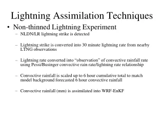
Lightning Assimilation TechniquesHow model assimilates lightning: LTNG2 • Original Lightning Experiment (LTNG2) • NLDN/LR lightning strike is detected • Lightning strike is converted into lightning rate from nearby LTNG observations • Lightning rate converted into convective rainfall rate using Pessi/Businger convective rain rate/lightning rate relationship • Relaxed WRF-EnKF quality control accepts more lightning strike convective rainfall values when comparing to background forecasts • Convective rainfall (mm) is assimilated into WRF-EnKF • Successful testing on Dec. 2002 case • Apply to other test case events • Test model adjustments to improve performance
Lightning Assimilation TechniquesHow model assimilates lightning: LTNG4 • Minimal Counting Technique Lightning Experiment (LTNG4) • NLDN/LR lightning strike is detected • Lightning strike is converted into lightning rate from nearby LTNG observations • Once any nearby lightning strikes are used to calculate a lightning density they are no longer available as an assimilation point (although they are still used to calculate LTNG densities) • Lightning rate converted into convective rainfall rate using Pessi/Businger convective rain rate/lightning rate relationship • Relaxed WRF-EnKF quality control accepts more LTNG strike convective rainfall values when comparing to background forecasts • Convective rainfall (mm) is assimilated into WRF-EnKF • Successful testing on Dec. 2002 case • Apply to other test case events • Test model adjustments to improve performance
Model Estimate ExperimentsCan we further improve Dec 2002 performance? • Model-estimate and observations of cumulative convective precipitation calculated by LTNG density occasionally have large innovations leading to large increments in the model’s dynamical fields, possibly leading to locally unbalanced states • Set a upper bound on assimilated cumulative convective precipitation • Minimal Counting Technique Lightning Experiment (LTNG4) w/ modifications (LTNG5) • Same techniques as LTNG4 with upper bound (18mm) • Less improvement in analysis and forecasts • Original LTNG4 still best performing model to test further on new regimes • Original Lightning Experiment (LTNG2) w/ modifications (LTNG6) • Same techniques as LTNG2 with upper bound (18mm) • Less improvement in analysis and forecasts • Original LTNG2 still best performing model to test further on new regimes • Another solution • Reduce cumulative value of convective rain assimilated from 6- to 1-hr block (In-progress)
Case Studies (Case 1 Review) • Case #1: December 16-21, 2002 • Analysis • Extra-tropical cyclone minimum SLP with new modifications • SLP fields • WRF-EnKF v. Observations
Case Study #1 – December 2002Minimum SLP recorded at extra-tropical cyclone’s center Limiting upper bound of cumulative convective precipitation degrades analysis performance (LTNG5/6)
Case Study #1 – December 2002SLP Analysis Fields Correct location and intensity of SLP cyclone center for LTNG assimilations
Case Study #1 – December 2002WRF-EnKF v. Observations: Integrated Error of SLP LTNG assimilation reduces error over control
Case Studies • Case #2: October 4-7, 2004 • Analysis • Extra-tropical cyclone minimum SLP • SLP, H500 fields • WRF-EnKF v. Observations • Number of LTNG strikes during test case is much smaller than Dec. 2002 case
Case Study #2 – October 2004Minimum SLP recorded at extra-tropical cyclone’s center LTNG assimilated from 04/00 – 07/18 LTNG4 more accurately simulates min. SLP depth of extra tropical cyclone
Case Study #2 – October 2004SLP Analysis Fields Correct location and intensity of SLP cyclone center for LTNG assimilations
Case Study #2 – October 2004H500 Analysis Fields Correct location and intensity of H500 center for LTNG assimilations
Case Study #2 – October 2004H500 Analysis Fields LTNG4 pulls location of upper-level cyclone center too close to LTNG observations Reducing to 1-hr cumulative convective rain totals could weigh OBS correctly
Case Study #2 – October 2004WRF-EnKF v. Observations: Integrated Error of SLP LTNG assimilated from 04/00 – 07/18
Case Study #2 – October 2004WRF-EnKF v. Observations: Cloud top temperature v. Satellite LTNG2: 10/08 00
Case Study #2 – October 2004WRF-EnKF v. Observations: Cloud top temperature v. Satellite LTNG4: 10/08 00
Case Studies • Case #3: November 8-12, 2006 • Analysis • Extra-tropical cyclone minimum SLP • SLP, H500 fields • WRF-EnKF v. Observations
Case Study #3 – November 2006Minimum SLP recorded at extra-tropical cyclone’s center Only LTNG assimilated hours
Case Study #3 – November 2006SLP Analysis Fields Correct location and intensity of SLP cyclone center for LTNG assimilations
Case Study #3 – November 2006H500 Analysis Fields Correct location and intensity of H500 center for LTNG assimilations
Case Study #3 – November 2006WRF-EnKF v. Observations: Integrated Error of SLP LTNG assimilated from 08/00 – 11/18
Case Study #3 – November 2006WRF-EnKF v. Observations: Cloud top temperature v. Satellite LTNG2: 11/10 12
Case Study #3 – November 2006WRF-EnKF v. Observations: Cloud top temperature v. Satellite LTNG4: 11/10 12
In-progress/Future Work • In-Progress • Reduce WRF cumulative convective precipitation assimilation from 6- to 1-hr to avoid unbalanced states • 24-hr Forecasts for Oct 2004 Case • 24-hr Forecasts for Nov 2006 Case • Investigate robustness of Pessi/Businger lightning rate/convective rain rate relationship • Future Work • Test Case #4 – December 2006 • Implement UW-ATMS lightning rate/convective rain rate relationship • Investigate lightning/graupel relationship • Questions/Comments?