Download
1 / 22
220 likes | 295 Views
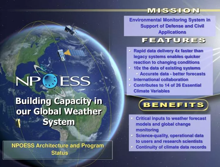
Environmental Monitoring System in Support of Defense and Civil Applications. Rapid data delivery 4x faster than legacy systems enables quicker reaction to changing conditions 10x the data of existing systems Accurate data - better forecasts International collaboration

E N D
Environmental Monitoring System in Support of Defense and Civil Applications • Rapid data delivery 4x faster than legacy systems enables quicker reaction to changing conditions • 10x the data of existing systems • Accurate data - better forecasts • International collaboration • Contributes to 14 of 26 Essential Climate Variables Building Capacity in our Global Weather System • Critical inputs to weather forecast models and global change monitoring • Science-quality, operational data to users and research scientists • Continuity of climate data records • NPOESS Architecture and Program Status
NPOESS Environmental Monitoring Regimes Nowcasting, Forecasting • Routine weather, disasters, military ops Weather, Oceanography Clouds, temperature, wind, precipitation, currents, tides, land use Space Environment Auroral particles, high energy space radiation Climate Environment Chemistry, water, land use Space Environmental Monitoring • Anomaly resolution, human space flight safety Long Term Monitoring • Global change implications
Polar Satellite Programs DMSP F19 NPOESS C2 DMSP F16 DMSP F20 DMSP F18 NOAA 17 MetOp-A MetOp-B MetOp-D MetOp-C NOAA 18 NOAA 19 NPP Calendar Year 2007 2008 2009 2010 2011 2012 2013 2014 2015 2016 2017 2018 2019 2020 2021 2022 2023 DMSP F17 AM Orbit MidAM Orbit PM Orbit NPOESS C3 NPP NPOESS C1 Defense Meteorological Satellite Program (DoD) NPOESS Preparatory Project (NASA/NOAA) Extended operation European Polar System (EUMETSAT) NPOESS(NOAA/DoD/NASA) Satellite is beyond design life Previous Schedule (through November 2008) NOAA Polar Satellite Program
Concept of Operations 2. Downlink raw data 1. Sense phenomena 3. Transport data to Centrals for processing X and L bands Ka-band Global fiber network connects 15 receptors to Centrals Field Terminals SafetyNetTM Receptors 4. Process raw data into EDRs and deliver to Centrals Monitor and control Satellites and Ground Elements Mission Management Center (Suitland) Alt. MMC (Aurora, CO) Full IDP Capability at each Central NOAA, Air Force, and 2 Navy sites
Data 1 Volume Spectral Capability Vertical Resolution Improvements Over Heritage Data Rate Encryption Heritage 1.5 Mbps 6.3 GB/Day Total 5 bands 40 bands NPOESS 20 Mbps 5.4 TB/Day Selective 22 bands 1300 bands Data Delivery DATA LATENCY – Delivery of Data to Users DMSP/POES NPP NPOESS 100 – 150 minutes 140 minutes 28 minutes 1 Data Volume per Satellite NPOESS improves robustness, accuracy, and timeliness of delivery of essential weather and climate data
Satellite Architecture Spacecraft designed for Earth observation missions • Large nadir platform for maximum payload accommodation on the EELV launch vehicle • Optical bench stability to ensure all sensors meet pointing requirements • Thermally optimized with large cold-side access for science payloads Overall Satellite • Orbit: 828 km • 13:30-C1 ascending node crossing • 17:30-C2 ascending node crossing • Capacity to transmit 5.4 Terabytes a day(half the library of Congress) • 7-year duration to ensure no operational gaps • Ka-Band downlink to SafetyNetTM enables downlink of all collected data with 4x improvement of data latency (95% of collected data delivered as EDRs in 28 min) • Large on-board recorder capacity and SafetyNetTM architecture provides 99.99% data availability • Leverages NASA’s Earth Observation Satellite (EOS) heritage and experience C1 1330 Satellite (note that C2 will have MIS) OMPS CrIS CERES SARSAT & A-DCS Tx Antennas ATMS L-Band LRD Link TSIS VIIRS X-Band HRD Link Ka-Band to Safety NetTM S-Band Link SARSAT & A-DCS Rx Antenna Velocity Direction (+XS/C axis) MIS Velocity Direction (+XS/C axis) CrIS & ATMS no longer manifested on C2 VIIRS ATMS CrIS TSIS S-Band Link X-Band HRD Link SARSAT & A-DCS Rx Antenna L-Band LRD Link SARSAT & A-DCS Tx Antennas C2 1730 Satellite Ka-Band to Safety NetTM
Visible Infrared Imaging Radiometer Suite (VIIRS) “In an overall view, it appears that the VIIRS/FU-1 will perform in a manner equal to or better than the MODIS instrument.” – NASA MODIS Science Team Lead
NPOESS/VIIRS Supports Superior Cloud Forecasting Clouds Cloud Shadows MODIS VIIRS AFWA Cloud Forecast Models Aerosols Aerosols • 22 spectral bands • Co-registered multi-spectral imagery • Cloud & Aerosol Detection bands • Thin Cirrus & Dual gain bands • Cloud Top Height, Cloud Top Base, Cloud Cover Layer, & Opt. Properties Opaque Cirrus Thin Cirrus Mixed Phase Clouds 4 Cloud Layers Water Clouds VIIRS Sensor Thin Cirrus CFLOS Opaque Water Clouds Better CFLOS Opaque Water Clouds CFLOS Superior Cloud Detection/Discrimination improves Cloud Free Line of Sight (CFLOS) determination VIIRS/NPOESS Provides: • 3D gridded cloud product, near Uniform Cell Size • CTH, CTB, CCL, COP and EPS Products • Feeds directly into AFWA high resolution Cloud Forecast Models Better Detection 412nm Dual Gain band gives superior contrast over desert and improved detection of smoke, dust, and haze Aerosols Detection • Improved Cloud Analyses for AFWA forecast models • Enhanced Aerosol Cloud Discrimination procedures • Increased knowledge of CFLOS to support missions • Higher quality products for military applications Superior Aerosol detection (dust, smoke, pollution)
Instrument Performance very promising – meets/exceeds KPPs & EDRs Ozone Total Column EDR Accuracy meets requirements with margin VIIRS 18.0 16.0 14.0 12.0 spec 10.0 Accuracy Error (DU) 8.0 6.0 Performance better than spec OMPS 4.0 2.0 0.0 50 150 250 350 450 550 650 Total Column Ozone (DU) Compliant region CrIS Simulation results SEA spec Pressure (mbar) Non-compliant region • All KPPs (bold boxes) Green • All NPP EDRs green except Aerosol Optical Thicknessand Ocean Color (based on flight sensor ambient testing) • All NPOESS EDRs green except Ocean Color (yellow; expected to go green following testing of integrated filter) Temperature (K) CrIS Atmosphere Vertical Temperature and Moisture Profile KPP EDRs met with margin due to outstanding sensor performance
Future Operational Weather Current Operational Weather LOW CLOUDS At Night Terrain FalseColor VIIRS 22 bands will provide improved discrimination of scene features Tough Problems Solved Smoke Plume Tanker On fire SNOW LOW CLOUD 3 Band True Color Black & White BANDS OLS: 1 Vis; 1 IR AVHRR: 1 Vis; 5 IR Dramatic enhancement of image content over single-band pan imagery [e.g. land surface types, water turbidity, and dust – cloud discrimination HIGH CLOUD Advanced ImageryImproves Interpretation Multispectral capability greatly enhances scene feature discrimination
Advanced Soundings Result in Better Forecasts NPOESS Fidelity Produces Global Forecast for national and military users Current Fidelity NPOESS Fidelity Where is Dujuan headed? Nat’l Hurricane Center Tanker Airlift Control Center What Air Refueling route is optimal? Currently 5–15 Channels Temperature and moisture profiles Hundreds of Channels All forecasts start with a global model
Upper-Level Circulation Lower-Level Circulation ~200km SE Monitoring Tropical Cyclones at Night • High-level circulation seen in Infrared DMSP/OLS 8/30/2004 0504 UTC 11.0 µm IR Window Eastern Pacific • Lower level cloud fields revealed via DMSP night time visible sensitivity Georgette 20 N • High vertical sheardisplacements between upper and lower level centers can be 200 km in some cases 15 N 125 W 120 W Avoiding the “Sunrise Surprise” NPOESS VIIRS Day Night Band will provide better spatial resolution with less noise
Synopsis • Real hardware and software being delivered • Command, Control and Communications System complete & installed at NOAA Satellite Operations facility (NSOF); transitioned to Operations and Support • Integrated Data Processing System is in transition to Operations and Support at NSOF and will be complete by June 2009 • NPOESS Sensor EDU integration and test with NASA NPP spacecraft completed • Sensor Flight Hardware completing rigorous testing • Operational Space Segment development on track for implementing Nation’s next generation environmental monitoring system On plan to provide critical national weather and climate monitoring system for assured data continuity
Wind Direction Wind Direction Manam Motu Papua New Guinea Volcanic Ash in Orange/Pink Clouds in Cyan True Color Volcanic Ash Monitoring Volcanic glass particles melt/damage turbine engines
Advanced Visible Imagery Supports Aviation Can you find the contrails in this true color image? Conditions for contrail formation made easy by exploiting numerous spectral bands! Long Contrail Loop Contrail NASA MODIS Processed Imagery Courtesy NRL Monterey
Advanced Vis/IR Imagery Improves Discrimination Note Multiple Dust fronts Vegetation Background Reference True Color Background Reference Next Day – Clouds Cover the River True Color Dust Event 500m Dust Enhancement Indus River Valley Pakistan DUST FRONT? DUST FRONT? NRL Monterey Special Dust Enhancement Algorithm Shows Dust Fronts
TED DPU MEPED Sensors for NPP, C1, C2 Environmental Sensors developed through EMD contract VIIRS OMPS CrIS ATMS** ** 1st procured by NASA 2nd by NG GPS (2) (2) (3) (2) Government Furnished Sensors being delivered for integration CERES MIS SARSAT A-DCS SEM (2) (2) (2) (1) (1+1) NPOESS Sensor suite delivers 38 Environmental Data Records and 14 Essential Climate Variables
NPOESS Payload Development Status –Nov 2008 CrIS Instrument (ITT) VIIRS Instrument (Raytheon) OMPS Instrument (Ball) Cross-track Infrared Sounder • with ATMS provides atmospheric temperature, moisture, and pressure profiles • EDU successfully tested with NPP spacecraft and returned • CrIS Thermal Vacuum (TVAC) testing shows excellent low noise performance • Internal Calibration target (ICT) anomaly resolved. ICT replaced and sensor completed TVAC test • Upcoming: Delivery to NPP satellite for integration Visible/Infrared Imager/ Radiometer Suite • provides 22 EDRs of atmospheric and surface environmental data • Pre-Environmental Test Review completed April 2008 • Sensor Suite integrated and environmental testing started • EMI testing completed, over test corrections in place with no impact on hardware • Upcoming: Vibration testing Ozone Mapping & Profiler Suite • provides ozone data • All testing successfully completed (Vibration, EMI and TVAC) • Successfully delivered a “high quality” instrument (per Pre-Ship Review Independent Review Chair) • Upcoming: Integration onto NPP satellite
NPOESS Payload Development Status –Nov 2008 ATMS Instrument (NGES) CERES Instrument (NGST) TSIS Instrument (LASP) Advanced TechnologyMicrowave Sounder • with CrIS provides atmospheric temperature, moisture, and pressure profiles • Flight Unit 1 delivered for NPP satellite integration in 2005 • Delta Critical Design Review (CDR) for replacement of obsolete components held in Sep 2008 Clouds and Earth’s Radiant Energy System provides data on incoming and outgoing radiant energy • Flight Module 5 approved for flight by NASA for NPP satellite. • Successfully delivered and integrated onto the NPP satellite in Nov 08 Total Solar Irradiance Sensor provides data on the amount of energy emitted by the Sun incident on Earth • Approved by EXCOM for C1 satellite on 1 May 2008 • NASA to procure TSIS from Laboratory of Atmospheric and Solar Physics (LASP) • Delivery planned for Dec 2011 to C1 satellite
NPOESS Payload Development Status –Nov 2008 (ATK) (ATK) MIS Instrument (NRL) SEM Instrument (JHU/APL) A-DCS (CNES) & SARSAT (DND) Microwave Imager Sounder • provides soil moisture and sea surface winds • Naval Research Center (NRL) chosen as the sensor provider with authority to proceed (ATP) in Jun 08 • Flight 1 Critical Design Review in 2011 with delivery in 2014 providing adequate margin to the C2 satellite need date Space Environmental Monitor provides data on charged particles entering the Earth’s atmosphere • NAVSEA/JHU team officially started work in Sept to support delivery to C1 • Advanced Data Collection System &Search and Rescue Satellite-Aided Tracking • monitors data from unmanned sites & relays distress signals from mariners and aviators in distress • In production and on track
OLS VIIRS Incorporates Key Features From and Improves Upon Previous Operational and R&D Sensors Operational Sensors • AVHRR • High Spatial Resolution • Day/Night Band • Minimize Resolution Growth Over Scan • Radiometric Accuracy • SST Band Continuity • 74 kg • 2 bands • VIIRS • 33 kg • 5 bands R&D Sensors OMM EM • MODIS • 275 kg • 22 bands • SeaWiFS • Band Selection/Continuity • Thin Cirrus Band • Solar Diffuser • Earthshine Lessons Learned • Ocean ColorBands • RotatingTelescope • 220 kg • 36 bands • 45 kg • 8 bands