Download
1 / 11
450 likes | 1.49k Views
Proceedings of Challenges in the European Area: Young Scientist’s 1st International Baku Forum, 20-25 May 2013 Baku AZERB AI JAN. APPLICATIONS OF TERRESTRIAL LASER SCANNING . Karolina Hejbudzka , PhD student Andrzej Dumalski , PhD

E N D
Proceedings of Challenges in the European Area: Young Scientist’s 1st International Baku Forum, 20-25 May 2013 Baku AZERBAIJAN APPLICATIONS OF TERRESTRIAL LASER SCANNING Karolina Hejbudzka,PhD studentAndrzejDumalski, PhD University of Warmia and Mazury in Olsztyn, Facultyof Geodesy and Land Management Institute of Geodesy Olsztyn Poland Institute of Geodesy University of Warmia and Mazury in Olsztyn
Laser Scanner Technology airborne laser scanning terrestrial laser scanning mobile laser scanning Idea of laser scanningmeasurements Institute of Geodesy University of Warmia and Mazury in Olsztyn
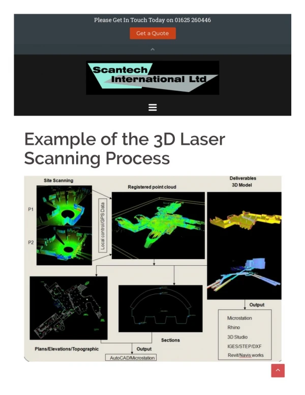
provides highly accurate, three-dimensional data inshort time; • is able to record millions of 3D points; • captures complex 3D environments faster than alternativetechniques; • gives milion of points in the cloud whichhave X, Y, Z and I (intensity); • measurements can be imported into CAD or 3Dapplication software and displayed on a computer monitor as a "point cloud”. Terrestrial laser scanner University of Warmia and Mazury in Olsztyn Institute of Geodesy
3. Point cloud – Modeling 2. Processing data 1. Measurement Typicalsteps University of Warmia and Mazury in Olsztyn Institute of Geodesy
Application of terrestrial laser scanning • as-builtsfacilities, • archeology, • architecture, • construction, • engineering, • heritagepreservation, • geodesy, • virtual reality, etc. University of Warmia and Mazury in Olsztyn Institute of Geodesy
High Gatein Olsztyn Poland University of Warmia and Mazury in Olsztyn Institute of Geodesy
Churchin Bezlawki in Poland University of Warmia and Mazury in Olsztyn Institute of Geodesy
Chamberin Olsztyn Castle University of Warmia and Mazury in Olsztyn Institute of Geodesy
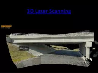
Dome on UniversityLibraryin Olsztyn Bridge in Gdańsk University of Warmia and Mazury in Olsztyn Institute of Geodesy
Informationobtainedfromterrestrial laser scanner University of Warmia and Mazury in Olsztyn Institute of Geodesy
Contact: Karolina Hejbudzka, PhD student e-mail: karolina.hejbudzka@uwm.edu.pl Andrzej Dumalski, PhD e-mail: andrzejd@uwm.edu.pl Thankyou for yourattantion University of Warmia and Mazury in Olsztyn Institute of Geodesy