Download
1 / 1
10 likes | 109 Views
Gales Creek Watershed. Prepared by: Amanda Tondreau Hannah Thoman ES 341. General Geology

E N D
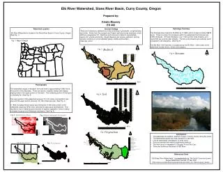
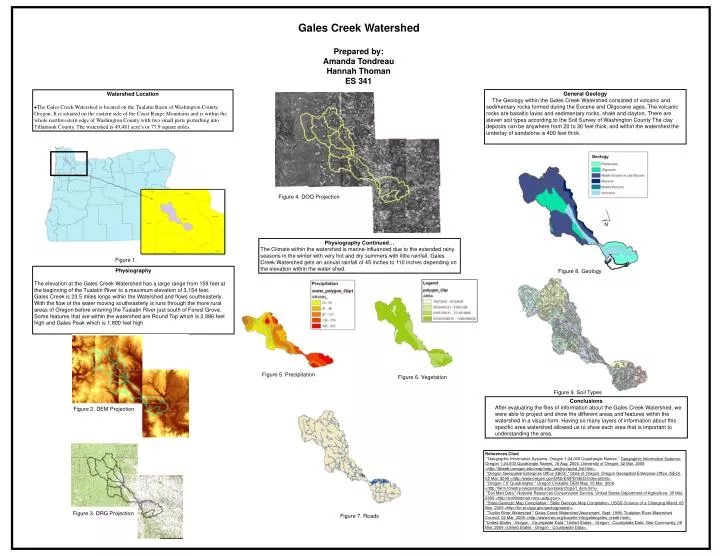
Gales Creek Watershed Prepared by: Amanda Tondreau Hannah Thoman ES 341 General Geology The Geology within the Gales Creek Watershed consisted of volcanic and sedimentary rocks formed during the Eocene and Oligocene ages. The volcanic rocks are basaltic lavas and sedimentary rocks, shale and clayton. There are eleven soil types according to the Soil Survey of Washington County The clay deposits can be anywhere from 20 to 30 feet thick, and within the watershed the underlay of sandstone is 400 feet thick. • Watershed Location • The Gales Creek Watershed is located on the Tualatin Basin of Washington County, Oregon. It is situated on the eastern side of the Coast Range Mountains and is within the whole northwestern edge of Washington County with two small parts perturbing into Tillamook County. The watershed is 49,481 acre’s or 77.9 square miles. Figure 4. DOQ Projection Physiography Continued… The Climate within the watershed is marine-influenced due to the extended rainy seasons in the winter with very hot and dry summers with little rainfall. Gales Creek Watershed gets an annual rainfall of 45 inches to 110 inches depending on the elevation within the water shed. Figure 1. Physiography The elevation at the Gales Creek Watershed has a large range from 159 feet at the beginning of the Tualatin River to a maximum elevation of 3,154 feet. Gales Creek is 23.5 miles longs within the Watershed and flows southeasterly. With the flow of the water moving southeasterly is runs through the more rural areas of Oregon before entering the Tualatin River just south of Forest Grove. Some features that are within the watershed are Round Top which is 2,986 feet high and Gales Peak which is 1,800 feet high. Figure 8. Geology Figure 5. Precipitation Figure 6. Vegetation Figure 9. Soil Types Conclusions After evaluating the files of information about the Gales Creek Watershed, we were able to project and show the different areas and features within the watershed in a visual form. Having so many layers of information about this specific area watershed allowed us to show each area that is important to understanding the area. Figure 2. DEM Projection References Cited "Geographic Information Systems: Oregon 1:24,000 Quadrangle Names." Geographic Information Systems: Oregon 1:24,000 Quadrangle Names. 18 Aug. 2006. University of Oregon. 02 Mar. 2009 <http://libweb.uoregon.edu/map/map_section/quad_list.htm>. "Oregon Geospatial Enterprise Office (GEO)." State of Oregon. Oregon Geospatial Enterprise Office (GEO). 05 Mar. 2009 <http://www.oregon.gov/DAS/EISPD/GEO/index.shtml>. "Oregon 7.5' Quadrangles." Oregon Clickable DEM Map. 05 Mar. 2009 <http://ferm.forestry.oregonstate.edu/research/gis/t_dem.htm>. "Soil Mart Data." National Resources Conservation Service. United States Department of Agriculture. 05 Mar. 2009 <http://soildatamart.nrcs.usda.gov/>. "State Geologic Map Compilation." State Geologic Map Compilation. USGS-Science of a Changing World. 05 Mar. 2009 <http://tin.er.usgs.gov/geology/state/>. "Tualtin River Watershed." Gales Creek Watershed Assesment. Sept. 1998. Tualation River Watershed Council. 02 Mar. 2009 <http://www.trwc.org/tualatin-info/gales/gales_creek.html>. "United States - Oregon - Countywide Data." United States - Oregon - Countywide Data. Geo-Community. 05 Mar. 2009 <United States - Oregon - Countywide Data>. Figure 3. DRG Projection Figure 7. Roads