Download
1 / 1
20 likes | 114 Views
NOAA’s Transition to Operations of S-NPP and Multi-satellite Blended Satellite Products. Tom Schott NESDIS/OSD Tom.Schott@noaa.gov. Kevin Berberich NESDIS/OSD Kevin.Berberich@noaa.gov. Stacy Bunin Noblis sbunin@noblis.org.

E N D
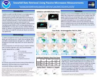
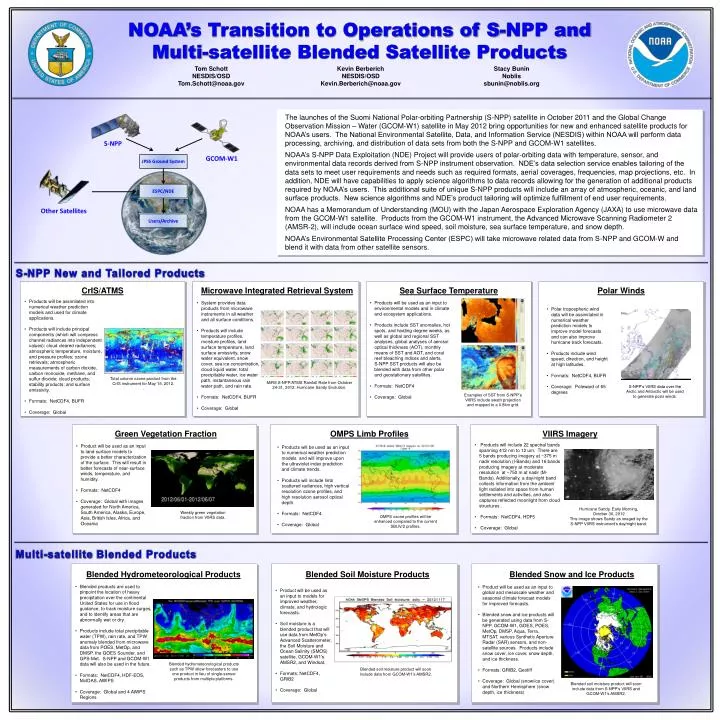
NOAA’s Transition to Operations of S-NPP and Multi-satellite Blended Satellite Products Tom Schott NESDIS/OSD Tom.Schott@noaa.gov Kevin Berberich NESDIS/OSD Kevin.Berberich@noaa.gov Stacy Bunin Noblis sbunin@noblis.org The launches of the Suomi National Polar-orbiting Partnership (S-NPP) satellite in October 2011 and the Global Change Observation Mission – Water (GCOM-W1) satellite in May 2012 bring opportunities for new and enhanced satellite products for NOAA’s users. The National Environmental Satellite, Data, and Information Service (NESDIS) within NOAA will perform data processing, archiving, and distribution of data sets from both the S-NPP and GCOM-W1 satellites. NOAA’s S-NPP Data Exploitation (NDE) Project will provide users of polar-orbiting data with temperature, sensor, and environmental data records derived from S-NPP instrument observation. NDE’s data selection service enables tailoring of the data sets to meet user requirements and needs such as required formats, aerial coverages, frequencies, map projections, etc. In addition, NDE will have capabilities to apply science algorithms to data records allowing for the generation of additional products required by NOAA’s users. This additional suite of unique S-NPP products will include an array of atmospheric, oceanic, and land surface products. New science algorithms and NDE’s product tailoring will optimize fulfillment of end user requirements. NOAA has a Memorandum of Understanding (MOU) with the Japan Aerospace Exploration Agency (JAXA) to use microwave data from the GCOM-W1 satellite. Products from the GCOM-W1 instrument, the Advanced Microwave Scanning Radiometer 2 (AMSR-2), will include ocean surface wind speed, soil moisture, sea surface temperature, and snow depth. NOAA’s Environmental Satellite Processing Center (ESPC) will take microwave related data from S-NPP and GCOM-W and blend it with data from other satellite sensors. S-NPP GCOM-W1 JPSS Ground System ESPC/NDE Other Satellites Users/Archive S-NPP New and Tailored Products CrIS/ATMS Microwave Integrated Retrieval System Sea Surface Temperature Polar Winds • Products will be assimilated into numerical weather prediction models and used for climate applications. • Products will include principal components (which will compress channel radiances into independent values); cloud cleared radiances; atmospheric temperature, moisture, and pressure profiles; ozone retrievals; atmospheric measurements of carbon dioxide, carbon monoxide, methane, and sulfur dioxide; cloud products; stability products; and surface emissivity. • Formats: NetCDF4, BUFR • Coverage: Global • System provides data products from microwave instruments in all weather and all surface conditions. • Products will include temperature profiles, moisture profiles, land surface temperature, land surface emissivity, snow water equivalent, snow cover, sea ice concentration, cloud liquid water, total precipitable water, ice water path, instantaneous rain water path, and rain rate. • Formats: NetCDF4, BUFR • Coverage: Global • Products will be used as an input to environmental models and in climate and ecosystem applications. • Products include SST anomalies, hot spots, and heating degree weeks, as well as global and regional SST analyses, global analyses of aerosol optical thickness (AOT), monthly means of SST and AOT, and coral reef bleaching indices and alerts. S-NPP SST products will also be blended with data from other polar and geostationary satellites. • Formats: NetCDF4 • Coverage: Global • Polar tropospheric wind data will be assimilated in numerical weather prediction models to improve model forecasts and can also improve hurricane track forecasts. • Products include wind speed, direction, and height at high latitudes. • Formats: NetCDF4, BUFR • Coverage: Poleward of 65 degrees Total column ozone product from the CrIS instrument for May 15, 2012. . MiRS S-NPP/ATMS Rainfall Rate from October 24-31, 2012: Hurricane Sandy Evolution. S-NPP’s VIIRS data over the Arctic and Antarctic will be used to generate polar winds. Examples of SST from S-NPP’s VIIRS include swath projection and mapped to a 0.8km grid. Green Vegetation Fraction OMPS Limb Profiles VIIRS Imagery • Products will include 22 spectral bands spanning 412 nm to 12 um. There are 5 bands producing imagery at ~375 m nadir resolution (I-Bands) and 16 bands producing imagery at moderate resolution at ~750 m at nadir (M-Bands). Additionally, a day/night band collects information from the ambient light radiated into space from human settlements and activities, and also captures reflected moonlight from cloud structures . • Formats: NetCDF4, HDF5 • Coverage: Global • Product will be used as an input to land surface models to provide a better characterization of the surface. This will result in better forecasts of near-surface winds, temperature, and humidity. • Formats: NetCDF4 • Coverage: Global with images generated for North America, South America, Alaska, Europe, Asia, British Isles, Africa, and Oceania • Products will be used as an input to numerical weather prediction models and will improve upon the ultraviolet index prediction and climate trends. • Products will include limb scattered radiances, high vertical resolution ozone profiles, and high resolution aerosol optical depth. • Formats: NetCDF4 • Coverage: Global Hurricane Sandy, Early Morning, October 30, 2012This image shows Sandy as imaged by the S-NPP VIIRS instrument’s day/night band. Weekly green vegetation fraction from VIIRS data. OMPS ozone profiles will be enhanced compared to the current SBUV/2 profiles. Multi-satellite Blended Products Blended Hydrometeorological Products Blended Soil Moisture Products Blended Snow and Ice Products • Blended products are used to pinpoint the location of heavy precipitation over the continental United States for use in flood guidance, to track moisture surges, and to identify areas that are abnormally wet or dry. • Products include total precipitablewater (TPW), rain rate, and TPW anomaly blended from microwave data from POES, MetOp, and DMSP, the GOES Sounder, and GPS-Met. S-NPP and GCOM-W1 data will also be used in the future. • Formats: NetCDF4, HDF-EOS, McIDAS, AWIPS • Coverage: Global and 4 AWIPS Regions • Product will be used as an input to global and mesoscale weather and seasonal climate forecast models for improved forecasts. • Blended snow and ice products will be generated using data from S-NPP, GCOM-W1, GOES, POES, MetOp, DMSP, Aqua, Terra, MTSAT, various Synthetic Aperture Radar (SAR) sensors, and non-satellite sources. Products include snow cover, ice cover, snow depth, and ice thickness. • Formats: GRIB2, Geotiff • Coverage: Global (snow/ice cover) and Northern Hemisphere (snow depth, ice thickness) • Product will be used as an input to models for improved weather, climate, and hydrologic forecasts. • Soil moisture is a blended product that will use data from MetOp’sAdvanced Scatterometer, the Soil Moisture and Ocean Salinity (SMOS) satellite, GCOM-W1’s AMSR2, and Windsat. • Formats: NetCDF4, GRIB2 • Coverage: Global Blended hydrometeorological products such as TPW allow forecasters to use one product in lieu of single-sensor products from multiple platforms. Blended soil moisture product will soon include data from GCOM-W1’s AMSR2. Blended soil moisture product will soon include data from S-NPP’s VIIRS and GCOM-W1’s AMSR2.