Download
1 / 18
180 likes | 284 Views
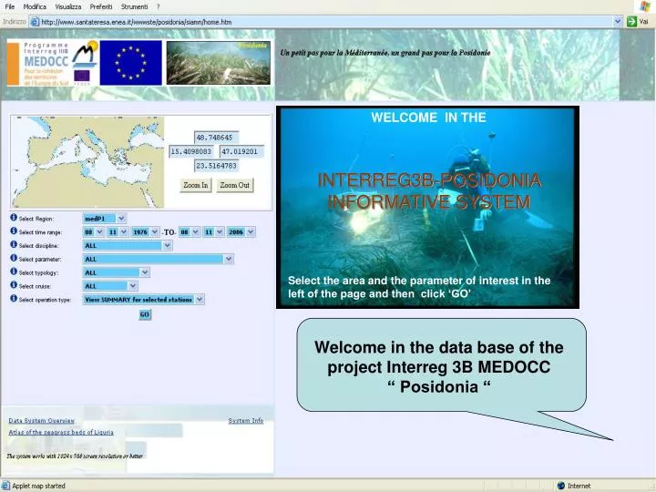
WELCOME IN THE INTERREG3B-POSIDONIA INFORMATIVE SYSTEM Select the area and the parameter of interest in the left of the page and then click ‘GO’. Welcome in the data base of the project Interreg 3B MEDOCC “ Posidonia “. WELCOME IN THE INTERREG3B-POSIDONIA INFORMATIVE SYSTEM

E N D
WELCOME IN THE INTERREG3B-POSIDONIA INFORMATIVE SYSTEM Select the area and the parameter of interest in the left of the page and then click ‘GO’ Welcome in the data base of the project Interreg 3B MEDOCC “ Posidonia “
WELCOME IN THE INTERREG3B-POSIDONIA INFORMATIVE SYSTEM Select the area and the parameter of interest in the left of the page and then click ‘GO’ …now, you can select a region drawing a rectangle
WELCOME IN THE INTERREG3B-POSIDONIA INFORMATIVE SYSTEM Select the area and the parameter of interest in the left of the page and then click ‘GO’ ....or select one region from the list
WELCOME IN THE INTERREG3B-POSIDONIA INFORMATIVE SYSTEM Select the area and the parameter of interest in the left of the page and then click ‘GO’ …fill the windows of interest and then push the buttom “GO”
The results of the research are showed in the new window on the right. All the labels and numers outlined are actives. Also the red points on the maps are actives. for instance… if you clic on a red point, that is one sampling station…..
…a new window appears on the top of the page with the characteristics (latitude, longitude, date etc.) of the selected station
RESERVED AREA Only after a log-in procedure the data will be showed You can download them simply by clicking on “Download”
…is showed the graph. In this case the green line is the limit of a Posidonia meadow. In the blue bar on the left you can select the tools to measure, to zoom, or to calculate the position and the depth of the point on the limit
…the ‘metadata’ are showed. They gather all the characteristics of the selected station and other informations as references, images and videos
Other graph tools are disponible as: Bar plots Vertical contouring Try them !!!!
Select “Polyline selection”
….following the instructions at the bottom of the map, draw a line passing nearby each red point (stations) of interest, then click “SUBMIT”
The buttoms of the window “OPTION” will allow wou to see (top of the page) or export the stations list
Select the depth range and the desired parameter (PAR) …. in the ‘Histogram’ line … one histogram will appear in one new window on the left of the page. You can modify the histogram selecting your preferred sequence in the column ‘Sel’
…and now… try by yourself the ‘Vertical contour’ option selecting the “Hydrology data ctd H. prec” stations at the start of the research