Download
1 / 17
280 likes | 1.08k Views
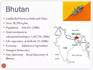
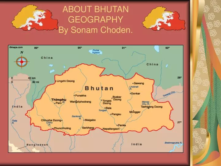
ABOUT BHUTAN GEOGRAPHY By Sonam Choden. GEOGRAPHY OF BHUTAN. Bhutan is 6 hours ahead of Greenwich Mean Time ( GMT ). Bhutan GMT +6. Geographic coordinates: 27 30 N, 90 30 E Located between the China on the north and India on the south. Bhutan's total borders amount to 1,075 kilometers.

E N D
GEOGRAPHY OF BHUTAN Bhutan is 6 hours ahead of Greenwich Mean Time (GMT). Bhutan GMT +6. Geographic coordinates: 27 30 N, 90 30 E Located between the China on the north and India on the south. Bhutan's total borders amount to 1,075 kilometers. Total area: 18,147 sq mi (47,000 sq km)
POPULATION • Population (2008 est.): 2,376,680 • Capital and largest city (2003 est.): Thimphu (official), 60,200 • Ethnicity/race: Bhote 50%, ethnic Nepalese 35%, indigenous or migrant tribes 15% • Religions: Lamaistic Buddhist 75%, Indian- and Nepalese-influenced Hinduism 25% • Literacy rate: 47% (2003 est.)
Natural geography • Bhutan's climate is as varied as its altitudes • Annual precipitation ranges widely in various parts of the country with average of around 1,000 millimeters • The Himalayas dominate the north of the country • The Kula Kangri, at 7 553 m • Gangkhar Puensum the highest at 7570 m
Political Geography • Bhutan is divided into 20 dzongkhag, and further into 201 gewog. • Each dzongkhag is headed by a dzongdag (district administrator) • The process of decentralisation of the administration started in 1981
Strategic Location • The heartland of Bhutan has never been invaded by any one. • India has a special relationship with Bhutan • The Tibetans have strong cultural, historical, and religious connections to Bhutan.
ECONOMIC SUMMARY • GDP/PPP (2007 est.): $3.359 billion; per capita $5,200. • Agriculture: rice, corn, root crops, citrus, foodgrains; dairy products, eggs. • Industries: cement, wood products, processed fruits, alcoholic beverages, calcium carbide • Natural resources: timber, hydropower, gypsum, calcium carbide. Ap ki mrs ko regards day • Exports: $154 million (electricity ), cardamom, gypsum, timber, handicrafts, cement, fruit, precious stones, spices.
TOURISM OF BHUTAN • “High Value, Low Volume” • Responsible Tourism • Unique Character • Authenticity • Quality
TOURISM IN BHUTAN • 2008: Number one destination to visit • 2007: Top Country (Wanderlust) • Top foreign exchange earner
Travel Information • By air or land • Package holiday can be booked through both International and Bhutanese local tour operators • Free individual travel is not allowed
Travel Information Daily Tariff • High Season Tariff US$ 250 per person per night halt • Low Season Tariff US$ 200 per person per night halt
Travel Information The minimum price includes: • All internal taxes and charges • Accommodation • All Meals • All travel with a licensed Bhutanese Tour Guide • All Internal Transport • Camping Equipment for Trekking Tours
Travel Information Visa Formalities • The visa will be stamped in the passport on payment of US$20 at the entry point but the clearance must be obtained before coming to Bhutan