Download
1 / 74
740 likes | 750 Views
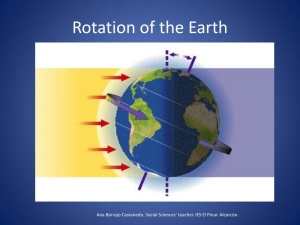
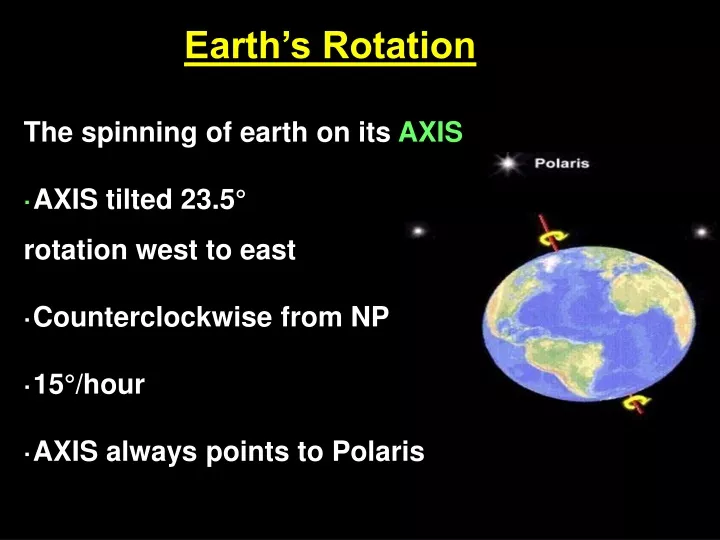
Earth’s Rotation. The spinning of earth on its AXIS · AXIS tilted 23.5° rotation west to east ·Counterclockwise from NP ·15°/hour ·AXIS always points to Polaris. What are the APPARENT DAILY MOTIONS of Celestial Objects?.

E N D
Earth’s Rotation The spinning of earth on its AXIS ·AXIS tilted 23.5° rotation west to east ·Counterclockwise from NP ·15°/hour ·AXIS always points to Polaris
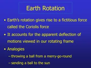
What are the APPARENT DAILY MOTIONS of Celestial Objects? ·The apparent motion is caused by Earth’s rotation west to east 15 ° / hour (counterclockwise) ·For example, the stars appear to move from east to west. The paths are circular or parts of a circle called an arc.
Celestial Sphere: A huge imaginary sphere around the Earth to which the stars appear to be attached. But in reality the celestial sphere is stationary and the earth is rotating counterclockwise ALL MOTION 15°/HR
Stars appear to be moving from east to west. Stars rising in the east.
Stars appear to be moving from east to west. Rise in the east and set in the west.
Stars appear to move in the shape of an arc east to west because Earth is moving west to east (counterclockwise) except in the Northern Sky where they circle Polaris http://www.reviewearthscience.com/subjects/es/review/100ill/3.html
The complete circular path can be seen for stars in the northern part of the sky around Polaris Circumpolar constellations never set. Circumpolar constellations change with latitude
The complete circular path can be seen for stars in the northern part of the sky around POLARIS Circumpolar Constellations never set but They do change with latitude
LAB 1C: The Altitude of Polaris Altitude of a Celestial Body – a star’s angle above the horizon. Polaris – the North Star Horizon – the boundary between the Earth’s surface and the sky.
How does the SHAPE of the Earth affect our view of the stars?
We will be taking a “virtual” field trip to different spots on the Earth and viewing the stars there. We are going to focus in on two major constellations, and one very important star—Polaris, or the North Star.
As you may already know, our view of the constellations change over an evening—the stars appear to move because the Earth is rotating! Your view of the sky at 9:00 p.m. is different from your view at 11:00 p.m. We will be viewing the sky at the same time in every location we go to! ****Polaris is the exception to this!!!
Our first stop is Central Park in New York City!
#1. New York, New York 41o N Latitude Big Dipper Cassiopeia Polaris Pointer Stars
We are going to “calibrate” our screen so that we can make measurements of the location of Polaris in other places on Earth. We will be using a device called a “sextant.” This measures the star’s angle above the horizon. This is called ALTITUDE. This simulation is only in 2-D, so the sextant appears like a ruler. However, in the real-world of 3-D, this device would measure what angle you have to tilt your head up in order to see a star.
70 New York, New York 41o N 60 Big Dipper Cassiopeia 50 Polaris 40 30 Pointer Stars Measure the altitude of Polaris 20 10 0
What does this view “feel like” in 3-dimensions? POLARIS The arc represents the Celestial hemisphere (the sky above) E 41o HORIZON N S W The ground There is a 41 degree angle between the horizon and Polaris. In other words, the viewer must tilt his or her head (and telescope!) up 41o from the horizontal in order to directly see Polaris.
BEFORE YOU MOVE ON TO LOCATION #2, did you: • Mark location #1 on the map (pg.3) with a red or orange colored pencil. • Plot Polaris on Dome #1 (pg.4) and fill in the Location & Latitude.
Now let’s head to Tampa, Florida and view the night sky there!
70 #2. Tampa, Florida What is the altitude of Polaris in Tampa? 60 50 40 30 20 10 0
What is the altitude of Polaris in Tampa? Again, let’s get a feeling of what this looks like in 3-D!
What does this view “feel like” in 3-dimensions? Plot the position of Polaris for Tampa The arc represents the Celestial hemisphere (the sky above) E HORIZON N S W The ground In Tampa, would you tilt your head up more or less than in New York in order to see Polaris?
70 #2. Tampa, Florida Did you notice that the Big Dipper, and Cassiopeia are also lower in the sky here… 60 50 40 30 20 10 0
70 #1. New York, New York 41o N …than in New York! 60 50 40 30 20 10 0
SO WHAT HAVE WE LEARNED ABOUT THE ALTITUDE OF POLARIS and LATITUDE?
Now we are flying off to Popayán, Colombia in order to view the tropical night sky!
70 #3. Popayán, Colombia 60 What is the altitude of Polaris in Popayán? 50 40 30 20 10 0
What is the altitude of Polaris in Popayán? MARK IT ON DOME #3
What is the latitude of Popayán? Plot it in Red on your map
Let’s see if you are getting the hang of this! For our next stop we are going to view the sky and then predict our latitude from the altitude of Polaris!
70 O.K.! Let’s determine the altitude of Polaris… 60 50 40 30 20 10 0
So where is Polaris in this location? The arc represents the Celestial hemisphere (the sky above) E HORIZON N S W The ground PLOT the Altitude of Polaris on your dome diagram
Of the choices given, where in the world are we? Churchill, Canada Quebec, Canada Hartford, CT Washington, D.C. New Orleans, LA
Now that you’re so good at this, predict the altitude of Polaris at the North Pole!
Let’s imagine what it would be like to do this at the North Pole. This is LOCATION #5 Be careful you don’t strain your neck!
80 70 60 50 40 30 20 10