Download
1 / 26
260 likes | 377 Views
Bart Croes, P.E. Chief, Research Division California Air Resources Board September 19, 2007. Harbor Communities Monitoring Study. Air Pollution and Premature Death California estimates for 2005. * At least a factor of two uncertainty. California’s Disproportionate Air Pollution Exposure.

E N D
Bart Croes, P.E. Chief, Research Division California Air Resources Board September 19, 2007 Harbor Communities Monitoring Study
Air Pollution and Premature DeathCalifornia estimates for 2005 * At least a factor of two uncertainty.
California’s Disproportionate Air Pollution Exposure Annual PM2.5(U.S. standard = 15 µg/m3) 8-Hour Ozone(U.S. standard = 80 ppb) Rest of Nation 59% Rest of Nation 37% California 41% California 63% Population-weighted and minus National Ambient Air Quality standard (NAAQS), based on 2000-2002 data.
Regional PM2.5 Hot SpotsBased on South Coast AQMD measurements Courtesy of Dr. Michael Jerrett, UC Berkeley
Local Diesel PM Hot SpotsBased on air quality modeling Stationary sources only Stationary and mobile sources Preliminary results from ARB Planning and Technical Support Division
Harbor Communities Monitoring Study - Goals Assess community exposure • Measure local pollution “hot spots” • Test low-cost easy-to-use monitors • Determine impacts of local versus regional sources • Establish baseline for Goods Movement Emission Reduction Plan effectiveness
Study Design • Harbor Communities • Wide range of pollution sources • Residential neighborhoods impacted • Complementary monitoring tools • East-to-use “passive” monitors • Particle counters • Mobile monitoring platform • Measure each season • PM2.5 health effects driven by annual average • Air toxic cancer risk based on long-term exposure • Meteorology varies by season
Objective: Test whether affordable, non-pump driven “passive” samplers are sensitive and accurate enough for community use Can they detect gradients? Can they accurately predict yearly averages from four months of one-week samples? “Passive” Sampler Network(Prof. Eric Fujita, Desert Research Institute)
Seven-day Time-integrated Samplers Ogawa passive samplers for NOX, NO2, and SO2 (thumb size in cup shield) AirMetric Minivol PM2.5 Sampler (20” long by 7” in diameter) Radiello passive samplers for H2S, formaldehyde, acetaldehyde, acrolein, BTEX, and 1,3-butadiene (size of a roll of pennies)
Particle Counter Network(Dr. Katharine Moore andProf. Constantinos Sioutas, USC) • Objective • Determine local versus regional sources, weather and seasonal impacts, etc. • Network of 13 particle counters • Particle number dominated by “ultrafine” particles (<0.1µm) • Ultrafine particles good indicator of combustion • February through November, 2007
USC Equipment Free-standing weather-proof shelter with tripod on top (for weather station) Particle counter
NLB SLB
DAES DRI Core DRI Core + continuous NLB DRI Passive only R_1 USC OCN SCAQMD Port of Los Angeles WBC HUD R_2 Port of Long Beach R_4 R_3 WILM W710 R_6 E710 R_7 BFL R_5 LBPW SLB E110 SPPS SE LBIH R_8 R_9 R_10 FS49 SWIL R_11 LBOH TITP LHP B47
Mobile Monitoring Platform(Kathleen Kozawa, Air Resources BoardProfessor Arthur Winer, UCLA) Objective: Find air pollution “hot spots” using Toyota RAV4 Electric Vehicle instrumented with real-time monitors • Are they consistent throughout the day, week, and year? • Can the sources by identified?
Measurement Parameters • Particles • PM2.5 mass • black carbon (BC) • particle-bound polycyclic aromatic hydrocarbons • number and size distribution • Gases • carbon dioxide (CO2) • carbon monoxide (CO) • nitrogen oxides (NOX, NO, NO2) • total volatile organic compounds (VOC) • Meteorology • Wind speed and direction, T, RH • Traffic documentation and location
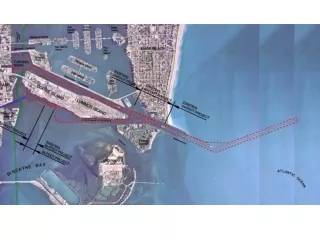
Sources Ports Freeways Refineries Rail yards Heavy-duty diesel truck traffic on surface streets Route Development Source locations, prevailing winds Community input Low-income neighborhoods Traffic counts Dispersion modeling Electric vehicle range, road access Basis for Route Selection
Residential Route:Identifying Pollution “Hot Spots” Near ICTF Carson Residential Santa Fe West Santa Fe East Wilmington NW Wilmington NE Wilmington SW Wilmington SE = Low Income Areas = Petroleum Refinery
Effect of Location on “Hot Spots”Sample Day 1 – Fall 2006 pilot study
Effect of Location on “Hot Spots”Sample Day 2 – Fall 2006 pilot study
Effect of Road Type and Time of DaySingle sample day – Fall 2006 pilot study
Preliminary Results(Fall 2006 pilot study and Winter 2007) • Monitoring Tools • Easy-to-use monitors less expensive/good accuracy compared to standard methods (for 1-week averages) • Hold promise as community screening tool • Pollution Exposure • Increased pollutant levels in AM relative to PM • Large day-to-day, week-to-week, seasonal variability • Higher week-to-week than location-to-location variability in levels of most pollutants • Data from remaining three seasons needed for more health relevance and definitive conclusions
Preliminary Results(Fall 2006 pilot study and Winter 2007) • Sources of Pollution • Higher PM2.5 occurred when regional contributions were apparently significant • Higher pollutant levels closer to roadways, especially for diesel-related emissions • Sulfur dioxide and hydrogen sulfide highest downwind of Conoco Refinery, but no corresponding increase in air toxics
Study Status • Completed monitoring • February-March, May-June, August 2007 • Upcoming monitoring • November 2007 • Complete study results available in 2008 • Focus on health relevance and sources • New studies • Community deployment of easy-to-use monitors in West Oakland (Prof. Manual Pastor, USC) • Develop low-cost PM2.5 monitor based on smoke alarm technology (Prof. Kirk Smith, UC Berkeley)
Acknowledgments • Air Resources Board: Steve Church, Pablo Cicero-Fernandez, Kevin Cleary, Mike FitzGibbon, Ying-Kuang Hsu, Chris Jakober, Whitney Leeman, Steve Mara • Desert Research Institute: Barbara Zielinska, Brooks Mason, Anna Cunningham, Judith Chow, Steven Kohl, Barbara Hinsvark, Brenda Cristani • Port of Long Beach • Port of Los Angeles • South Coast Air Quality Management District: Phil Fine, Chung Liu, Jean Ospital • Toyota Motor Corporation • University of Nevada, Reno: Pat Arnott • University of Southern California: Scott Fruin, Meg Krudysz, Payam Pakbin, Neelakshi Hudda, Andrea Hricko • Community Monitoring Location Hosts: Balthasar Alvarez, Dan Berns and the Berns Company, City of Los Angeles, City of Long Beach, John Cross, Los Angeles Fire Department Battalion 6, Jesse Marquez, Orange County Nursery, Southern California Edison, Superior Electrical Advertising, Inc., Westside Baptist Church, other community volunteers
Further Information www.arb.ca.gov/research/mobile/hcm/hcm.htm Leon Dolislager at (916) 323-1533 or ldolisla@arb.ca.gov Bart Croes at (916) 323-4519 or bcroes@arb.ca.gov 26