Download
1 / 37
420 likes | 1.3k Views
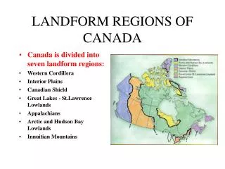
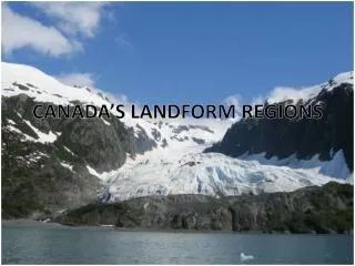
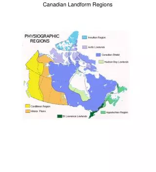
Landform Regions of Canada. An Overview. Canada’s Landforms. Canada is made up of three distinct landforms – shield, highlands, lowlands. There are 7 Landform Regions of Canada. Where are we?. Canada’s Landform Regions. Great Lakes-St.Lawrence Lowlands Canadian Shield

E N D
Landform Regions of Canada An Overview
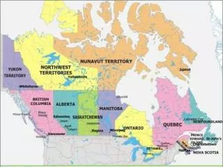
Canada’s Landforms • Canada is made up of three distinct landforms – shield, highlands, lowlands. • There are 7 Landform Regions of Canada. • Where are we?
Canada’s Landform Regions • Great Lakes-St.Lawrence Lowlands • Canadian Shield • Appalachian Mountains • Arctic and Hudson Bay Lowlands • Innuitian Mountains • Interior Plains • Western Cordillera
The Canadian Shield • The foundation of Canada, which covers more than half of Canada. • Some of the world’s oldest rocks are located in the shield (3.96 billion years old) • Today the Canadian Shield is relatively flat with rounded hills of rock.
Money from the Shield • Two types of rock form the shield: • Igneous and Metamorphic • The shield contains valuable minerals: • Lead, Gold, Nickel, Copper • Diamonds have also been found in the ancient rock.
How did these minerals get there? • Mineral deposits were present in magma that forced its way into the cracks of the shield. • As it cooled, the minerals were deposited into these cracks. • This process deposited a wealth of minerals which are the foundation of our northern mining industry.
Mining Towns • Sudbury, Ontario • Thompson, Manitoba • Yellowknife, NWT. They rely on the minerals of the shield to create jobs and generate exports to be sent across Canada and the World.
The Canadian Shield - continued • The shield is not well suited for farming • It is an ideal place for recreation because of the scenic rivers, forests, waterfalls, lakes, and rock outcrops. • The glaciers gouged out depressions in the bedrock which created thousands of lakes. • The bedrock is impervious so the water stays.
The Lowlands • The bedrock under the lowlands is formed mainly of sediments eroded from the Shield. • The sediments were laid down in the seas that existed millions of years ago, and the compression formed sedimentary rock.
Interior Plains • Part of the Great Plains of North America. • The inland seas that formed these contained coral reefs, that eventually eroded away and compressed deep below the surface. • These ancient reefs formed into the famous oil and gas deposits of Alberta.
Interior Plains - continued • The differential erosion of the sedimentary rock has created escarpment of hard to erode material. • Glacial erosion created the many lakes across the plains including Lake Winnipeg. • The soil that developed on the sediments is very fertile and as a result the Prairies have become our ‘breadbasket’, because of the production of wheat.
Great Lakes - St. Lawrence Lowlands • This region consists of two parts that are separated by a thin line of the Shield. • Similar to the Interior Plains, the inland seas formed sedimentary rock. • The differential erosion can be seen at the Niagara Escarpment.
Great Lakes • The Great Lakes portion was heavily affected by glaciation. Evidence can be seen in the rolling landscape. • The Great Lakes are located in basins that were gouged out by glaciers. • The lakes used to be much bigger, and the old shorelines can still be seen today.
St. Lawrence Lowlands • Formed by a rift valley that developed by faulting. • The rift valley was flooded at the end of the last ice age. • This landform region is great for agriculture because of excellent soil and warm climate. • About 50% of Canada’s population lives in this region, which comprises only 14% of Canada’s area.
Hudson Bay – Arctic Lowlands • A very flat and low lying area of swamps. • The Arctic lowlands are made up of a series of islands in Canada’s far north. • The harsh climate does not permit farming, as the ground is permafrost. • The sedimentary rock contains coal, oil, and natural gas deposits.
Appalachian Mountains • Stretch from Georgia to Newfoundland. • Oldest highland region in Canada, and millions of years of erosion have reduced them to rolling mountains and hills. • Glaciation played a big role in the erosion. • Drowned Coastline was formed when river valleys were drowned by rising sea levels. • Major harbours were created by this.
Innuitian Mountains • They measure up to 2500 metres in height in Canada’s far north. • Formed in the Mesozoic when the North American Plate moved north. • They are younger than the Appalachians, so erosion has not affected them as much. • These mountains are barren due to their location above the tree line.
Western Cordillera • The great height and rugged appearance tell us they are younger mountains. • Created by the collision of the North American and Pacific plates. • They run in a north-south direction and present a barrier for transportation. • The mountains contain many alpine glaciers that are actively carving the ranges.
Western Cordillera • There are three major mountain divisions: • Eastern Mountains • Rocky Mountains and Columbia Mountains • Interior Plateaus • Okanagan Valley – fruit basket of Canada • Coast Mountains • Many fjords formed after glaciation.
Western Cordillera • The continuous movement of the North American and Pacific plate make the Coast Mountain area the most active earthquake centre of Canada. • In the past 70 years there have been more than 100 earthquakes.