Download
1 / 17
170 likes | 188 Views
The Infinite Grid SM. INTRODUCTION. Uses: Coordinates from a reference datum Direction Magnitude A Vector. Conventional Mapping. These maps are vector based, where map features are referenced as points. That keeps the file size small, but screen drawing time long.

E N D
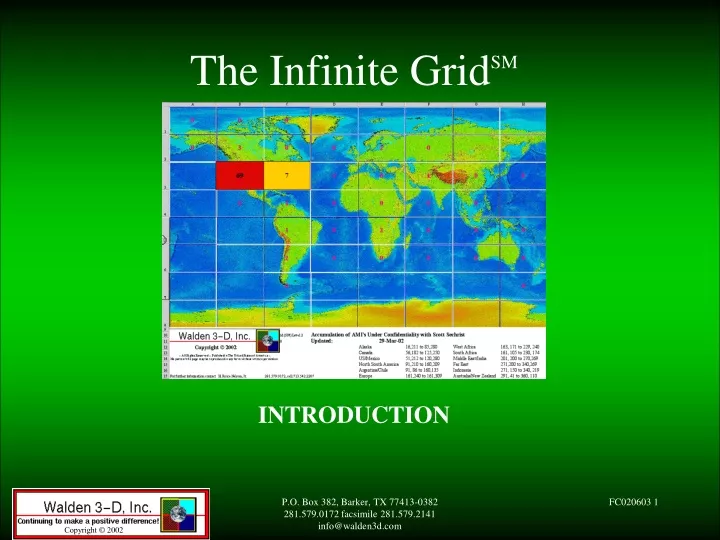
The Infinite GridSM INTRODUCTION P.O. Box 382, Barker, TX 77413-0382 281.579.0172 facsimile 281.579.2141 info@walden3d.com
Uses: • Coordinates from a • reference datum • Direction • Magnitude • A Vector Conventional Mapping P.O. Box 382, Barker, TX 77413-0382 281.579.0172 facsimile 281.579.2141 info@walden3d.com
These maps are vector based, where map features are referenced as points. • That keeps the file size small, but screen drawing time long Conventional Mapping • They define a horizontal direction of Longitude where the surface of a sphere is divided into 360°. • They define a vertical direction of Latitude where a hemisphere is divided into 180 °. P.O. Box 382, Barker, TX 77413-0382 281.579.0172 facsimile 281.579.2141 info@walden3d.com
The Infinite GridSM divides Longitude and Latitude into tiles of area. All features and information are referenced by area, not by vector. The Infinite GridSM • The difference is subtle - but very far-reaching P.O. Box 382, Barker, TX 77413-0382 281.579.0172 facsimile 281.579.2141 info@walden3d.com
The Infinite GridSM highest level (IG0) encompasses the whole globe in one tile. This is divided into 9 X 9 tiles, each covering 45 ° Long. and 22.5 ° Lat. for level IG1. Each IG1 tile is in turn divided into smaller tiles, and at IG8 each tile size is approximately 11.8 x 6.9 ft. The Infinite GridSM Each tile is reference by the tile number vertically and horizontally at each level. Thus an IG1 tile might be 23. An IG2 tile might be 14.46. An IG3 tile might be 21.45.33, etc. P.O. Box 382, Barker, TX 77413-0382 281.579.0172 facsimile 281.579.2141 info@walden3d.com
The Infinite GridSM P.O. Box 382, Barker, TX 77413-0382 281.579.0172 facsimile 281.579.2141 info@walden3d.com
Why not use Longitude & Latitude references instead of Infinite GridSM references? 1. Since Longitude and Latitude already describe map axes, a separate reference scheme is needed to describe areas. 2. Only two single digits are needed to indicate each tile for an IG (Infinite GridSM) reference. P.O. Box 382, Barker, TX 77413-0382 281.579.0172 facsimile 281.579.2141 info@walden3d.com
This arrangement allow XML referencing of all data that can have an IG reference attached to be displayed together. Why is all this important? That means that a common access format solves all the problems of combining mapping and spatial data together. It also puts the power in the hands of the average user - to relate data from disparate sources directly on the desktop. P.O. Box 382, Barker, TX 77413-0382 281.579.0172 facsimile 281.579.2141 info@walden3d.com
Before the spreadsheet was invented, business financial planning and reporting was the domain of experts. Could it really make a difference? NOW, the power is in the hands of the average user. This has restructured business radically. P.O. Box 382, Barker, TX 77413-0382 281.579.0172 facsimile 281.579.2141 info@walden3d.com
Before the Internet, business intelligence was difficult to collect. Remember the days before the Internet? Who buys anything, now, without getting all the pertinent information, and comparing the competitor’s products before buying? P.O. Box 382, Barker, TX 77413-0382 281.579.0172 facsimile 281.579.2141 info@walden3d.com
A windows style application • A ‘vanilla’ map of the globe • Sets of standard templates • A set of presentation tools – color codes, overlay orders, transparency options formatting, arrows, text boxes, etc. • Curvature correction The Infinite GridSM -> the ‘New Excel’ • A 3D rotator for XYZ views • A data editor window for arrays of data like spreadsheet etc. • A sequencer for time phased data • A scripter or macro editor P.O. Box 382, Barker, TX 77413-0382 281.579.0172 facsimile 281.579.2141 info@walden3d.com
Topography Drill plan maps Outcrop maps Palaeontology maps Sample analyses Drilling reports Lithography Wireline Case Study - Petroleum Combine and overlay Drill down Look in 3D Look for gaps Look for relationships Extrapolate for strata and geology P.O. Box 382, Barker, TX 77413-0382 281.579.0172 facsimile 281.579.2141 info@walden3d.com
XML allows content to be directly located by search engines XML coded IG data and graphics make the internet a magnificent access tool to extract relationships between all kinds of knowledge Infinite GridSM and the Web Giving access to data is a mandate for many sectors of government. Selling data is the value point of business. IG and the internet creates the ideal connection tool for both. P.O. Box 382, Barker, TX 77413-0382 281.579.0172 facsimile 281.579.2141 info@walden3d.com
Sources of Infinite GridSM data Public data Local government Bureau of Statistics Meteorological Agricultural Geographical Health Non-profit organisations Commercial data Financial Trading Specialised databases Export Sales and Product data Project data Research P.O. Box 382, Barker, TX 77413-0382 281.579.0172 facsimile 281.579.2141 info@walden3d.com
How to Convert to IG Databases & Spreadsheets Images & Mapping IG Spatial Co-ordinates & Timestamp Cadastral Raster Data Record + Convert Long. & Lat. to IG P.O. Box 382, Barker, TX 77413-0382 281.579.0172 facsimile 281.579.2141 info@walden3d.com
Pro’s & Con’s ofVector Mapping • Computationally intensive • Can only database point coordinates • Is not inherently graphical • Not convenient to search • Multitude of incompatible file standards Pro’s Con’s • Existing • Universal in some applications • Small data files • Relates to physical things P.O. Box 382, Barker, TX 77413-0382 281.579.0172 facsimile 281.579.2141 info@walden3d.com
Pro’s & Con’s ofthe Infinite GridSM • Easy to merge and compare unrelated data • Available as to be an interchange format • Easy to visualise and self-consistent • Dynamically drill-able • Area based rather than point based • Inherently graphical Pro’s Con’s • Larger data files • Requires conversion step from vector P.O. Box 382, Barker, TX 77413-0382 281.579.0172 facsimile 281.579.2141 info@walden3d.com