Download
1 / 6
60 likes | 192 Views
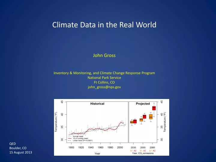
Climate Data in the Real World. John Gross Inventory & Monitoring, and Climate Change Response Program National Park Service Ft Collins, CO john_gross@nps.gov. QED Boulder, CO 15 August 2013. Common uses for climate data from projections:.

E N D
Climate Data in the Real World John Gross Inventory & Monitoring, and Climate Change Response Program National Park Service Ft Collins, CO john_gross@nps.gov QED Boulder, CO 15 August 2013
Common uses for climate data from projections: • Planning: Foundation Document, General Management Plans, Resource Strategies, CC scenario and other workshops • Assessments: CC vulnerability, coastal & watershed assessments • Specific resource projects: weed management, species of concern, hydrology, visitor services, infrastructure, visitor safety, revegetation (fire, construction, etc.) • Education: Interpretation and outreach Needs range from very general trends to somewhat sophisticated. One size fits nobody.
What’s appropriate trend measurement, variance / confidence? • What ‘ensemble’ or models to use? • Some variables or metrics of interest ‘unpopular’ (e.g. wind)
CC Vulnerability Assessment of SE Forest Birds – Sillett, Hostettler et al. • Land cover change, climate • PRISM 800 m for 512 BBS routes • Demographic models, fitted with PRISM • Need 6-10 downscaled model projections • Need Apr-June ‘aridity’ index –> temp & precip • What GCMs to use (not use)? • Does downscaling technique matter? • How to estimate ‘aridity’? • Other projects: • species distribution modeling (pika, limber pine, bighorn sheep, vetch, etc.) • VAs – many parks • State of Parks Reports • Infrastructure projects (many!)
Key needs: • Area-specific evaluations of projections for core variables • Summary of downscaling methods (strengths/weaknesses; best uses) • Access to projection & ensemble summaries, and/or ability to specify & generate • Guidance on identification, selection, and appropriate use of downscaled climate projections