Download
1 / 17
180 likes | 388 Views
ASGS – ADCIRC Surge Guidance System CERA – Coastal Emergency Risks Assessment. real-time interactive tool during emergency situations. development and validation tool for coastal modelers. Coastal Emergency Risks Assessment (CERA).

E N D
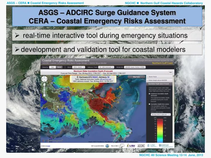
ASGS – ADCIRC Surge Guidance SystemCERA – Coastal Emergency Risks Assessment • real-time interactive tool during emergency situations • development and validation tool for coastal modelers
Coastal Emergency Risks Assessment (CERA) • CERA helps emergency managers to get qualified assessments during critical hurricanes situations • NGCHC - verify models and model methods; provide alternative model runs (ISAAC 2012)
CERA Clients • NOAA NWS Lower Mississippi River Forecast Center - Slidell, LA • NOAA NWS Forecast Center - Lake Charles, LA • Governor’s Office of Homeland Security and Emergency Preparedness (GOHSEP), LA • GIS Community • U.S. Geological Survey • Stephenson Disaster Management Institute @ LSU • Lake Pontchartrain Basin Foundation • Hazards and Vulnerability Research Institute, University of South Carolina • Louisiana Sea Grant • U.S Coast Guard • National Hurricane Center
Real-time RADAR accumulated rainfall • WMS service to retrieve rainfall imagery from NOAA’s nowCoast Jason Smith
Contour Lines and GIS Shape Files • generate ESRI compatible shape files from ADCIRC output Andrew Kemp
CERA on mobile devices • design and develop a CERA mobile interface Rufei Zhou, Howard Wang
Testing Hurricane Wind Fields and Grids with ADCIRC Hurricane ISAAC (Aug 21 – Aug 30 2012) Real-Time Forecasting Results Hindcast Modeling Comparison of ISAAC hindcasts with 5 distinct sets of meteorological data Real-time results every 6 hrsin accordance to advisories as issued by NHC Collaboration between LSU, MSU, UNC • Data Factory (LSU) • Hurricane Modeling • Toolbox (MSU) • ASGS/CERA (LSU) ASGS North Carolina
Used ADCIRC grids during ISAAC Multi-state effort during active hurricane events Pat Fitzpatrick (MSU) Nate Dill, Jason Fleming (for LSU)
Impacts of using different ADCIRC grids FEMA R4 grid – best resolution for MS/AL CPRA grid – best resolution for southeastern LA
Impacts of using different ADCIRC grids ~ 10-12 ft storm surge (Plaquemine Parish levee overtopping 8 ft) CPRA grid FEMAR4 grid
Lake Borgne surge barrier Impacts of using different ADCIRC grids • Digital Elevation • Model (MSU) CPRA grid FEMAR4 grid Task: development of a unique ADCIRC grid for LA, MS, AL • ASGS/CERA (LSU)
ISAAC hindcasts on CERA Developer website • CPRA grid • 5 different wind models • ADCIRC Asymmetric Vortex Model • LSU Wind Model with background winds • NOAA Hurricane Research Division (HWind) • OceanweatherFast Delivery Meteorology (OWI) • MSU Wind Model (FITZ Wind Scheme)