Download
1 / 54
540 likes | 680 Views
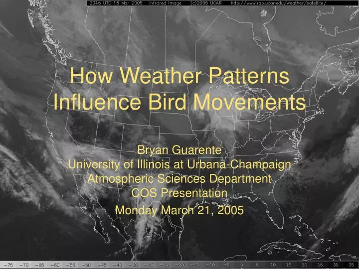
How Weather Patterns Influence Bird Movements. Bryan Guarente University of Illinois at Urbana-Champaign Atmospheric Sciences Department COS Presentation Monday March 21, 2005. Outline. Bird Navigation How To Read Weather Maps Two Caveats Case Studies Helpful Resources. Bird Navigation.

E N D
How Weather Patterns Influence Bird Movements Bryan GuarenteUniversity of Illinois at Urbana-ChampaignAtmospheric Sciences DepartmentCOS Presentation Monday March 21, 2005
Outline • Bird Navigation • How To Read Weather Maps • Two Caveats • Case Studies • Helpful Resources
Bird Navigation • How do birds migrate? • Using landmarks (Point Peleé) • “Staying within the lines” • Highways (I-95) • Ridges (Blue Ridge: Hawk Mountain) • Coastlines (Atlantic Coast, Lake Michigan) • Magnetism of the earth • Sun, Stars, Moon • “Believing their instincts” • Avoiding weather or go with weather
Bird Navigation (cont) • Most important thing: • Which family of birds? • What habitat is needed? • What time of year? • “Circlers” (Soaring) • Falconiformes • Gruiformes • Direct Flights (short and long distance) • Anseriformes • Charadriiformes • Passeriformes
Bird Navigation (cont) • “Circlers” • Thermals: pockets of warm rising air • Thermals enhance a good migration day for circlers • Strong upper level winds also make for a good “circler” migration day • Thermals are not required but circlers will limit distances on days without thermals
Bird Navigation (cont) • Short Distance vs. Long Distance Migrants • Long migration isnot effected greatly by weather patterns • More dependant on season or amount of sunlight • Examples: Arctic Tern, Sandpipers, and Barnacle Goose • Short migration is effected greatly by weather patterns • Less dependant on season or amount of sunlight • Examples: Most Passerines and Waterfowl
Problems encountered • What would you do if you were flying and you encountered • Significant Cloud Coverage? • Frozen Precipitation? • Strong Winds opposing your motion? • Land! • Birds experience these conditions and are forced to land all the time.
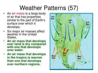
How’s the weather up there? • Upper atmosphere makes all the difference • BIRDS DO NOT MIGRATE AT SURFACE • Surface winds seldom important • Between 1km and 5km AGL winds are the biggest weather factor • 850mb (1km) to 500mb (5km) most important levels for winds • However, surface weather systems effect upper atmosphere • Surface cannot be ignored
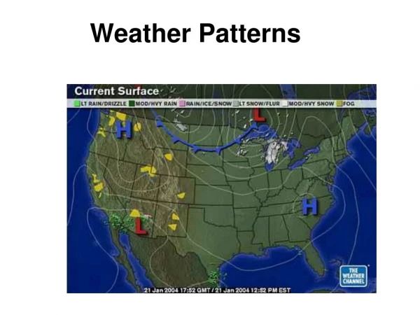
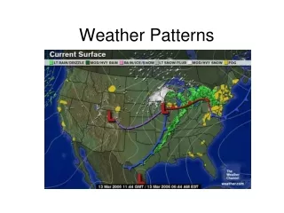
How to read weather maps • Birds prefer to follow winds (cross country flight example) • Most maps show winds • wind barbs • All directions are the same as a compass • Plotted as the direction the wind is FROM
How to read weather maps • Rotation of highs and lows visible on surface obs
How to read weather maps • Convergence and divergence will show areas of preferential movement to and from a location • Multiple kinds of convergence and divergence (directional and speed)
How to read weather maps • Areas of convergence and divergence visible
How to read weather maps • Streamlines • Shows direction a bird would travel… without outside forcing • Can see where migrants will come from or end up • Easiest way to see convergence at any level • Fronts become obvious (lines of convergence) • Fronts make some birds stop migration (strong pressure decline, assume bad weather) • Uncommonly plotted… especially for forecasts
How to read weather maps • 850 mb (1km up) • BEST place to look for strong winds that will promote movements • Strong winds from preferential direction = GOOD MOVEMENTS • Season dependant • Stronger winds at this level are called “low-level jet” • The end of a low-level jet has speed convergence (great place to look for migrants)
How to read weather maps • 700mb (2-2.5km up) • Good place to look for strong winds for migrants • Not as good as 850mb, but still important • Low-level jet also present at this level • Stacked strong winds (700mb strong winds above 850mb strong winds) = GOOD MOVEMENT
How to read weather maps • 500mb (5-6km) and 250mb (10-12km) • Winds at these levels only effect high altitude fliers • Hard to track these birds • Track vertical motions • Upward vertical motion may lead to movement • Barring cloud cover (which accompanies rising motion) • Unproven, but feasible
How to read weather maps • Jetstreaks and vertical motions • Jetstreaks: areas of fastest moving winds in jetstream • Dynamical effects cause divergence
How to read weather maps • Jetstream convergence and divergence
How to read weather maps • Infrared (IR) Satellite Imagery • Low pressure systems look like commas • High clouds versus low clouds • Figure out low level winds from low clouds (if present) • Sometimes see areas of preferred heating of the ground (areas good for circlers) • Nighttime cloud cover
How to read weather maps • Visible Satellite Imagery • Low pressure systems look like commas • Cloud levels not clear in some cases • Visible satellite not available at night
How to read weather maps • Water Vapor (WV) Satellite Imagery • Low pressure systems sometimes look like commas • Rotations can be seen very clearly • Rotations are usually associated with vertical motion and bad weather (can ground birds) • Jetstream pattern is often clearly visible • Can infer streamlines • Images available at night • Cannot see below 700mb
How to read weather maps • Radars • Radar Reflectivity • Two different modes used (for small particles and large particles) • Clear air mode • Precipitation mode • Clear air mode: • Easy to pick up fronts and smaller particles (clutter issues) • Precipitation cannot be present • Precipitation Mode • Hard to pick up fronts and smaller particles • Precipitation will be present • May be hard to distinguish birds from precipitation
Two Caveats?! • Good weather patterns do not always equal good migration • All weather forecasts are model produced • Models differ • Models are made using our current understanding of the atmosphere • Weather forecasts beyond three days are pipedreams • Because of this: models are NEVER correct! • BUT, we need to look for guidance somewhere
Experience is the key • As it is with birds: • The more you look, the more you understand • This may not come easy for some of you • Every day forecasts change • Look often and be flexible Are you ready for your first try?
What happened on this day? • Black-legged Kittiwake (Rissa tridactyla) showed up near Chicago (reported by Eric Walters) • Refer to emails on IBET (8077, 8078, 8082, 8087, 8091) for discussion of patterns • For sightings refer to IBET (8094 BLKI, 8096 BLKI, 8100 FEHA, 8101 SACR)
What happened on this day? • Sandhill Cranes (Grus canadensis) “clouded” the Chicago area skies (1,269 reported by Matt Karabestos; 400 reported by Leslie Cummings) • First real push of Sandhill Cranes (G. canadensis) all season • IBET posts (9514 – 9518, 9521, 9526, 9528)