Download
1 / 26
260 likes | 266 Views
A proposal to implement a GIFS-Forecast Demonstration Project over La Plata basin. Celeste Saulo, Univ. of Buenos Aires – Argentina with many thanks to Pedro Silva Dias and David Parsons THORPEX ICSC GIFS TIGGE Working Group Eighth Meeting Geneva, February 2010. Why La Plata Basin?.

E N D
A proposal to implement a GIFS-Forecast Demonstration Project over La Plata basin Celeste Saulo, Univ. of Buenos Aires – Argentina with many thanks to Pedro Silva Dias and David Parsons THORPEX ICSC GIFS TIGGE Working Group Eighth Meeting Geneva, February 2010
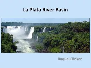
Why La Plata Basin? Inhabitants: 201.656.965 Area: 3.100.000 km2 La Plata Basin, is formed by the discharge of waters from five countries: Argentina, Brazil, Uruguay, Bolivia and Paraguay. Its population surpasses 200 millions. It accounts for the generation of most of the electricity, the food and the exports of these countries Mega-cities: Sao Paulo-Buenos Aires Other large cities: Asunción-Sucre-Montevideo
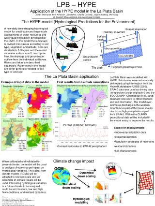
La Plata Basinprecipitation climatology 20S • Mean annual cycle (derived from CMAP 1979-2000) • Over the whole basin • Over the monsoonal region • Over the southern-central region 30S Caffera and Berbery, 2005
Synoptic variability and type of severe weather documented over LPB • Heavy and/or persistent rains (frequently leading to floods and slides) • SACZ (summer) – blocking events (winter) – MCS (spring and summer) – cyclogenesis (autumn and spring) • Severe storms (tornado, wind gusts, hail, intense precipitation, lighting, etc) • Droughts • Warm/cold spells • Late Frosts
MCS over South America From LPB implementation plan, 2005
Intense convective events according to different parameters More frequent Less severe Less frequent More severe From Zipser et al.2006
Most extreme 1% PFs in each category for each 2-degree latitude-longitude box (after Zipser et al, BAMS, 2006)
Blocking events: slides and heavy rains M. Seluchi (CONGREMET X, 2009)
Floods • There are 3 main sub-basins. The potential for flooding occurs at any time of the year The largest contribution during flood episodes comes from the Paraná River. Both the Paraná and the Uruguay rivers can at least triple the mean river discharge during flood events (Berbery and Barros 2002).
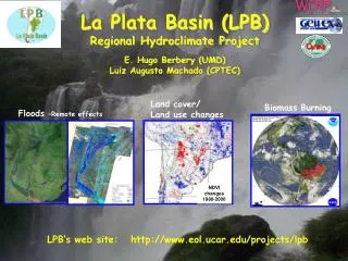
LPB is a Continental Scale Experiment that is being coordinated jointly by GEWEX and CLIVAR • What climatological and hydrological factors determine the frequency of occurrence and spatial extent of floods and droughts? • How predictable is the regional weather and climate variability and its impact on hydrological, agricultural and social systems of the basin? • What are the impacts of global climate change and land use change on regional weather, climate, hydrology and agriculture? Can their impacts be pre-dicted, at least in part?
Progress with Multi-Model Ensemble (NWP) Global Models: CPTEC, NCEP, UKMET Regional Models - increasing number of participants • CPTEC regional model (ETA) • Brazilian Navy (DWD model) • Smaller domain – limited to S/SE • Univ. of São Paulo – BRAMS • Federal University of Rio de Janeiro - WRF • National Laboratory for Computational Sciences – ETA,BRAMS • Univ. of Buenos Aires - WRF and BRAMS • Federal University of Santa Maria - BRAMS • 3 regional offices - WRF This is work has been supporting regional activities on the THORPEX/TIGGE - WMO.
Evaluation Metrics: • Fit to surface observations: • T2m, Td2m, U10m,V10m, press, rainfall, SW, • Implementing: SH, LH, LW, SW, based on Micromet towers (about 14 in Brazil) – connection to LBA, LPB, GABLS …
? Complex case... 11-12 days of useful forecast Note that this is particularly difficult period to forecast! Large discrepancies 7-8 days of usefull forecast
Products developed at CIMA (CONICET-UBA) http://wrf.cima.fcen.uba.ar
Which would be the advantages of focusing a GIFS-FDP in LPB from the regional perspective? • Heavy rainfall prediction is a critical issue • Although available, not enough use of ensemble products is currently done by forecast centers • Advantage of ensemble forecasting applied to severe weather has to be demonstrated • Efforts could be made to also link to hydrological prediction (given the high potential for flood occurrence over the area), which is currently experimental but based on deterministic forecasts • It would be of great interest to assess the impact of additional observations on forecast quality (particularly for MCS’s and explosive cyclogenesis) We could probably combine an FDP with a field experiment, with main focus on the impact of targeted observations on precipitation forecast skill • Air quality forecasts could be also incorporated, with a focus on aspects related with health
Science Issues: Improvement in Model Physics • How to deal with steep orography • Parameterization of convective rain: MCC’s are challenging! • Role of wetlands areas : Pantanal issue and extensive flooding • Role of biomass burning and megacity emissions in the precipitation Low Troposphere and Long Distance Transport of PM2.5 and CO Andes Low Level Jets2002 case study
Critical issues in the implementation of a regional project • Technical aspects • Product development according to regional needs • Capacity building
The project could make use of the extensive modeling expertise in Brazil and Argentina It could also build upon some existing initiatives A coordinating institution has to be identified (Brazil?) Experience from previous SWFDP needs to be transferred/adapted Technical aspects
Brasil - INMET - Brasilia INPE/CPTEC - C. Paulista DHN - Niteroi SIMEPAR - Curitiba CLIMERH - Florianopolis Paraguay - Dinac Uruguay - Dinamet Argentina - SMN Virtual Center for monitoring and forecasting severe weather for Southeastern South America Courtesy of M. Seluchi, CPTEC, Brazil
Product development according to regional needs • There is some local expertise in the development and use of products from EPS (mainly with a scientific approach). There are some TIGGE products already available through CPTEC and also a regional Super Model Ensemble System • End users and/or institutions making use of forecasts/warning systems need to be involved from the very beginning in order to generate specific products (could be a cross-cut with SERA??) • Although there are networks linking hydropower generation-agricultural sector-water management-etc. and weather services, an articulated work with these institutions is probably the most difficult task, mainly at an international level • Still it is worth the effort, since they can provide financial support for some of the activities
Capacity building • There are many Institutions that could be involved in this activity: • University of Buenos Aires • Intensive Course on Data Assimilation, november 2008 (co sponsored with WMO) • Training Institute on the use of seasonal climate predictions for applications in Latin America (co-sponsored with IAI) • Workshop on the Interdisciplinary Science of Climate Changes: Basic Elements (co-sponsored with ICTP) • National Weather Services (Brazil, Argentina) • Research centers (CPTEC, CIMA, others?)
Possible steps towards the organization of a FDP • To organize a training session as a means to increase involvement of South American countries. The topic should be ensemble prediction with a focus on GIFS-TIGGE. Training on verification techniques for ensemble prediction needs to be included. • Heavy rainfall is an area of strong interest within the region and thus the instruction should include the use of heavy rainfall prediction using ensembles. Experience from a SWFDP could be transferred/adapted with this aim. • Instructors need to include examples from the Southern Hemisphere and South America prediction problems • Language is an issue: spanish/portuguese spoken trainers should be appointed July 2011?
Thank you!!! • Questions? – Suggestions?
EndProduct SISMADEN riscos From Chou, Buenos Aires, Congremet– 4-9/10/2009 A prototype of a system that retrieves, stores, and processes hydro-meteorological data in conjunction with environmental information is developed and is being subjected to tests. The system uses a geographic database for information-sharing and stores hydro-meteorological data, specific risk maps, and any additional base maps. This system provides risk alert analyses related to natural disasters triggered by extremes of heavy rainfall, especially landslides and debris flows in the study region.