Download

1 / 1
10 likes | 99 Views
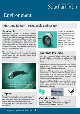
Difference in Depth (m). Subaqueous Depth (m). Subaerial Depth (m). -325.0 to -225.0. High : 156.0. High : 435.0. -225.0 to -155.0. -155.0 to -95.0. Low : 73.0. Low : 4.0. -95.0 to -40.0. -40.0 to 0.0. 0.0 to 55.0. 55.0 to 130.0. 0. 4,400. 8,800. 17,600. Meters. 0. 4,400.

E N D
Difference in Depth (m) Subaqueous Depth (m) Subaerial Depth (m) -325.0 to -225.0 High : 156.0 High : 435.0 -225.0 to -155.0 -155.0 to -95.0 Low : 73.0 Low : 4.0 -95.0 to -40.0 -40.0 to 0.0 0.0 to 55.0 55.0 to 130.0 0 4,400 8,800 17,600 Meters 0 4,400 8,800 17,600 Meters 0 4,400 8,800 17,600 Meters Environment Simulating the Bed Topography of Submarine Meanders Description of the research This research explores the implications of this behaviour with respect to the bed morphology of submarine channel bends. Submarine meanders scoured by turbidity currents are common features of the deep ocean floor. Hydrographic surveys have revealed aspects of their planform morphology, but their deep water location inhibits access, so knowledge of their fluid mechanics, sediment transport and bed morphology remains limited, conceptual models having been developed by analogy with the well understood mechanics of fluvial meanders, due to similarities between their planform shapes. Research results Our model replicates the relatively flat transverse bed profiles observed in the study bend very well, at least in those parts of the bend at, and downstream of, the apex (i.e., in the region of fully developed flow) Figures belowindicates thatsubmarine meanders exhibit key differences in bed morphology relative to equivalent fluvial bends: • In submarine bends the outer-bank pool is shallower and the ‘point-bar’ is less pronounced, giving a transverse bed profile that is much flatter • In submarine bends the ‘point-bar’ is located further downstream of the bend apex However, recent experimental investigations [Corney et al., 2006; Keevil et al., 2006] have revealed that the secondary flow structure in submarine channels with density-driven gravity currents is the opposite to that of fluvial bends (Figure 1). Unlike sub-aerial channels, in which the downstream velocity maximum occurs near the surface, gravity currents exhibit a near-bed maximum. This distinction results in the occurrence of outwards near-bed secondary flow, whereas near-bed secondary flow is directed inwards in the case of fluvial bends. These data reveal a spectacular meandering channel system (location: ~55.5N,137.5W) at a depth of ~3000 m, and with dimensions (wavelength = 39.8 km; sinuosity = 1.9; width = 4.75 km, depth = 115 m) consistent with other submarine channels Bathymetric survey data for the Gulf of Alaska region showing the meander system and specific bend modelled in this study. Data from: http://www.ccom- jhc.unh.edu/ for more information please contact: School of Geography, University of Southampton, S.E.Darby@soton.ac.uk Web: www.geog.soton.ac.uk School of Earth and Environment, University of LeedsJ.Peakall@see.leeds.ac.uk Web: www.see.leeds.ac.uk