Download
1 / 18
200 likes | 224 Views
ArcGIS for the Military: Creating and Sharing Military Overlays. Dan Barnes Joe Bayles. Current Workflows. PowerPoint is simple to use…. Current Workflows. … but hard to read. Map courtesy of the California National Guard. Future Workflows. The Art of the Possible. Agenda.

E N D
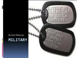
ArcGIS for the Military:Creating and Sharing Military Overlays Dan BarnesJoe Bayles
Current Workflows PowerPoint is simple to use…
Current Workflows … but hard to read. Map courtesy of the California National Guard
Future Workflows The Art of the Possible
Agenda • Background Information • Current Workflow • Military Standards • Military Symbology in Desktop • Current Esri Technology • Creating Overlays • Adding Symbols • Creating Symbols • Sharing Overlays • Publishing to the web map • Creating dynamic information products
Agenda • Background Information • Current Workflow • Military Standards • Military Symbology in Desktop • Current Esri Technology • Creating Overlays • Adding Symbols • Creating Symbols • Sharing Overlays • Publishing to the web map • Creating dynamic information products
Esri Support for Military Symbology Dedicated to mission success • Esri has supported military-standard symbology in ArcGIS for over 17 years: • ArcGIS 8.0-10.1 supported Military Overlay Editor (MOLE) • ArcMap 10.0-10.3.1 supported Military Features template • ArcGIS 10.4-Beyond support Military Overlay, and Military Tools for ArcGIS • Esri actively engages customers that use military symbology around the globe. • Esri also supports the standards committees, actively participating in the: • US DOD Symbology Standards Management Committee • NATO Joint Symbology Panel
MIL-STD-2525 and APP-6 Evolving Standards 03 10121100 SFGPUCIA-- 01
Military Overlay Information Model A schema that matches the military standard • Layer Package • Geodatabase Schema • Feature Templates • Schema contains multiple dictionary fields (the “keys”) • “Values” are used to identify specific symbol element • Attributes in schema drive symbology
Dictionary Renderer for ArcGIS Pro Dynamically update symbol based on attributes • Included in ArcGIS Pro • Optimized for fast search and retrieval of given symbol • Rule-based • Configurable Symbology and Text fields • Takes elements of Information Model and “combines” them to create a displayed symbol
Military Overlay Template Create and Share Overlays using Military Symbology • ArcGIS Pro Project Template • Combines the Military Overlay Information Model and Dictionary Renderer • Includes tasks that outline these workflows: • Create military standard symbols using Feature Templates. • Create a military overlay with dictionary renderer symbology. • Share the overlay as either a static image or an editable web map. • Also included is Military Symbol Editor Add-in
Creating Overlays Dan Barnes
Sharing Overlays Joe Bayles
Questions Stay tuned for resourcesand session information…
Legacy Standard Support What if I don’t use 2525D? • Available for ArcGIS Pro 1.2: • MIL-STD-2525C • MIL-STD-2525B (Change 2) • APP-6B • These will soon be available as alternate information models • Want to create your own dictionary? Our code is on GitHub!
Resources For more information about military symbology in ArcGIS • GitHub • Joint Military Symbology Markup Library • Military Features Data • ArcGIS Solutions Website • Military Features • Military Overlay • Military Overlay Information Model • Military Tools for ArcGIS • Military Standards • MIL-STD-2525 • NATO APP-6 • ADRP 1-02
Please take our Survey Your feedback allows us to help maintain high standards and to help presenters Find your event in the Esri Events App Find the session you want to review Scroll down to the bottom of the session Answer survey questions and submit