Download
1 / 14
150 likes | 500 Views
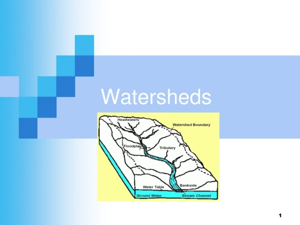
Watersheds. (CTDEP 2005). Watersheds. Aka drainage basin Area that one water body or point drains from Topography-dependant: Can be delineated easily by topographic maps “If it’s on the ground, it’s in the water.”. Topographic Map. (Skip if know how to read)

E N D
Watersheds • Aka drainage basin • Area that one water body or point drains from • Topography-dependant: Can be delineated easily by topographic maps “If it’s on the ground, it’s in the water.”
Topographic Map (Skip if know how to read) • Each topographic line represents an increment in elevation (2ft, 10ft, etc.) • Elevation given every 5-10 lines and at peaks/valleys • Closer together = steeper • % Slope = relief /distance *Exercise in measuring slope*
Water flows in direction of steepest downhill slope • Delineations run perpendicular to the topographic lines • Everything within red line (watershed) drains to the red dot (exit point) (Olivera, 2010)
Exercise in Delineation from Topographic Maps • Designate watershed outlet (mark) • Determine high points along watercourse (mark) • Connect high points with lines that are perpendicular to topographic contour lines. Eventually this line with loop all the way around the watershed. • Use following website to check your answer: http://streamstatsags.cr.usgs.gov/ct_ss/default.aspx?stabbr=ct&dt=1288293507905 **Note: must provide printed/printable map which corresponds with watershed online
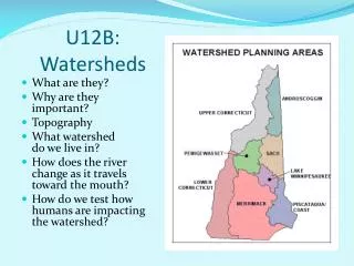
Watershed-Scale • Management/ partnership at watershed scale is important, because everything within watershed affects the water body at exit point • Scale can differ from small brooks within one town or county to the Connecticut river which starts in Canada (CRWC, 2010)
Watershed Attributes Topography • Controls the boundaries of the watershed • Depressions store water • Water runs off slopes • Watersheds may be nested within larger watersheds Size • Larger watersheds = more chance for water balance, but more contaminants • Surface water is cleaner at the top of a watershed because water hasn’t traveled far • Surface water at the bottom of a watershed is usually more polluted because it has traveled farther
Watershed Attributes Continued Land Cover (runoff coefficient /100) • Forests(0.05-0.25): Act as a sink for water because trees take up and transpire water; less disturbed forests allow good infiltration; filter pollutants • Urban (0.71-0.99): The higher the impervious cover, the less infiltration, the more runoff • Agricultural(0.08-0.41): Depends on tillage (soil compaction) • Residential(0.14-0.54): Impact depends on density because % impervious increases • Water (next text slide) (McCuen, 2004)
Watershed Attributes Continued Percent Water • Wetland, streams, lakes etc. store water either in depression or floodplains • Surface water that is stored does not runoff, and can replenish groundwater supplies via infiltration • Infiltration can also prevent rivers and lakes from becoming too low
Watershed Attributes Continued Boundaries • Political boundaries and groundwater do not follow watershed boundaries • Ground water under one watershed may be depleted or polluted by people in another watershed unintentionally • Thus, working within and across watershed boundaries is essential for watershed management
Key Steps in Watershed Management • Prioritize actions- i.e. better infrastructure, less impervious, more open space, more inspections & maintenance of septic, better practices for homeowners and landowners, resource & wildlife habitat restoration, nonstructural flood protection, better WM, pollution prevention, & recycling • Partnership- watershed ≠ political boundaries • Identify harmful activities- car maintenance, irrigation, etc. • Identify pollutants - agriculture, urban, etc. • Public education- like this • Follow up- often neglected, Universities can research (CT DEP 2010)
Works Cited CT DEP “Water.” Online Available: http://www.ct.gov/dep/cwp/view.asp?a=2719&q=325520&depNav_GID=1654 Retrieved 20 October 2010. Connecticut River Watershed Council. “River Info.” US Fish & Wildlife Online Available: http://www.ctriver.org/programs/recreation/river_info/index.htmlRetrieved 27 October 2010. Freeman, Paul. “Abandoned and Little-Known Airfeilds: Eastern CT.” Online Available: http://members.tripod.com/airfields_freeman/CT/Airfields_CT_E.htm Retrieved 2 November 2010. McCuen, R. H. “Hydrologic Analysis and Design.” Upper Saddle River, New Jersey: Prentice Hall. 3rd edition, 2004. Olivera, Francisco. “DEM-Based Stream and Watershed Delineation.” Texas A&M University Department of Civil Engineering. Online Available: https://ceprofs.civil.tamu.edu/folivera/CVEN423/Spring2007/GISCD-Spring07/10WatershedDelineation/Watershed%20Delineation.ppt#366,4,Watershed Delineation. Retrieved 26 October 2010.