Download
1 / 27
270 likes | 450 Views
Height Modernization Making the Most of the Indiana HARN and the INDOT CORS. March 14, 2007 By William A. Schmidt, PE, LS Manager of Aerial Engineering, INDOT Thomas A. Mahon, PE, LS Survey Group Manager, Woolpert Inc. Background – Surveying Infrastructure - Horizontal.

E N D
Height ModernizationMaking the Most of the Indiana HARN and the INDOT CORS March 14, 2007 By William A. Schmidt, PE, LS Manager of Aerial Engineering, INDOT Thomas A. Mahon, PE, LS Survey Group Manager, Woolpert Inc
Background – Surveying Infrastructure - Horizontal • NAD 27 – Best fit Spheroid for North America • Fifty nine years of terrestrial, local surveying by the general public • Line of sight required (Bilby towers) • Regional or large scale projects only conducted by National Geodetic Survey • Highest achievable relative accuracy was 1:100,000 • Network accuracy 10 m
Background – Surveying Infrastructure - Horizontal • NAD 83(86) – Best fit Global Ellipsoid, conventional observations along with satellite triangulation, Doppler positions, and VLBI • Incorporated satellite (non-GPS) observations into conventional data sets • Largest solution of simultaneously adjusted equations up until that time • 400,000 unknowns and 1,800,000 (observations) equations
Background – Surveying Infrastructure - Horizontal • NAD 83(86) Issues • Not GPS-able • Poor accessibility • Irregularly spaced • Positional accuracy • Relative 1:100,000 • Network 1 m
Surveying Infrastructure – Horizontal (cont’d) • Along came GPS • Private surveyors began finding issues with existing control • Large scale surveys no longer the domain of government surveyors • Projections and datums used • More ties to state plane coordinates • Both horizontal and vertical control in one operation • Overall horizontal accuracy improving
Surveying Infrastructure in Indiana – HARNs • “GPSABLE” Clear Horizons for Satellite Signal Acquisition • EASY ACCESSIBILITY Few Special Vehicle or Property Entrance Requirements • REGULARLY SPACED Always within 20-100 Km • HIGH HORIZONTAL ACCURACY A-Order (5 mm + 1:10,000,000) B-Order (8mm + 1:1,000,000)
Surveying Infrastructure in Indiana – Horizontal • Indiana HARN Phase I – 1997 (GPS1200) • Indiana HARN Phase II – 1998 (GPS1200) • Indiana HARN last of all 50 state HARN’s • No state HARN has better vertical component • NAD 83(97) Statewide Readjustment by NGS • ‘NAD 83’ no longer enough to define adjustment • Indiana HARN Phase III - 2003 (GPS1850) • FBN Vertical Enhancement Survey
High Accuracy Reference Network Positional Accuracy • HARN Stations • Network (absolute): 0.1 m • Relative • B-order: one part per million • A-order: one part per 10 million • CORS Stations • 0.01 m
Phases of Indiana Surveying Infrastructure – Horizontal (cont’d) • HARN Participants: • HARN Phase I - Collaborative effort between federal government, local government, private contractors (The Schneider Corporation & Plumb-Tuckett) and various volunteers • HARN Phase II - Private contractor (Woolpert LLP) • HARN Phase III - federal government, local government and various volunteers. No private contractor.
Indiana HARN Components: FBN/CBN • The Indiana HARN consists of stations maintained by the federal government and those maintained by the locals (anyone other than the federal government) • HARN – High Accuracy Reference Network (161 Total Points) • FBN – Federal Base Network (21), a subset of HARN stations sufficiently dense for the federal government to meet their surveying obligations within the state (100 km) • CBN – Cooperative Base Network (140), all other HARN stations, more densely spaced to meet local needs.
1991 GPS222 1996 1992 1996 1991 GPS1048 GPS341 1991 GPS197 1996 GPS805 reos 7/96 GP S291 1993 1994 reos-1996 GPS941 GPS1047 reobs 9/97 1996 GPS730 GPS606 1994 1995 1992 1995 GPS1121 1997 1997 GPS404 GPS887 1994 1991 GPS394 GPS882 GPS GPS260 GPS1178 1997 1997 1995 1993 1200 GPS633 1992 GPS908 1992 1993 GPS1150 GPS1179 GPS610 reos-6/95-GPS904 GPS412 GPS611 1995 GPS419 1992 1990 -GPS120 1997 GPS852 1993 GPS376 GPS1133 1993 1994 1992 GPS725 GPS366 GPS721 1992 GPS585 1990 1992 GPS383 reos 1/96 GPS936 -GPS170 GPS450 1993 GPS667 . GPS & CLASSICAL ADJUSTMENTS COMPLETED GPS ADJUSTMENT COMPLETED
Horizontal Control Stations • A-order (13@1:10,000,000 horizontal) Adjusted to VLBI stations (NCMN 7291 Bloomington), CORS stations and other FBN stations • B-order (148@1:1,000,000 horizontal) Adjusted to A-order stations • C-order (all 1st, 2nd, and 3rd order stations) Rubber sheeted to A & B-order stations
Horizontal Adjustments • NAD 83(97) • adjusted horizontal coordinates in Indiana based on the first two HARN campaigns • adjustment based on NAD 83(CORS) which had been adjusted in 1996 • adjustment tied into surrounding readjustment • adjusted coordinates moved on the order of magnitude of ±1’ in Indiana • adjusted only satellite observations and rubber sheeted conventional control into HARN stations
Horizontal Adjustments • NAD 83(NSRS2007) • NSRS - National Spatial Reference System • readjustment of all GPS data in the National Spatial Reference System simultaneously, not just a state or regional readjustment • adjustment tied to CORS network as of 2002 • adjusted data in Indiana to be available Spring 2007 • states on stable North American plates will not be given an epoch date (considered fixed)
Phases of Surveying Infrastructure – Vertical • NGVD 29 – National Geodetic Vertical Datum of 1929 (sea level) • Thousands and thousands of km of level loops run since 1929 • NAVD 88 – North American Vertical Datum of 1988 • Many monuments have move or been destroyed over the years
Phases of Indiana Surveying Infrastructure – Orthophotography & DEM • Statewide Digital Color Orthophotography – 2005 • Statewide Color Infrared Aerial Photos – 2005 • Statewide Digital Elevation Model – 2005 • Statewide Digital Surface Model – 2005 • gis.iu.edu • Google Earth
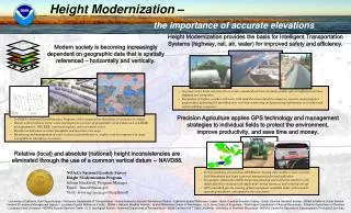
What’s Next – Height Modernization • Height Modernization is any program aimed at improving elevation estimates • Typical activities have included: • differential leveling establishing/re-establishing elevations on horizontal control stations • survey mark recovery and remonumentation • GPS surveying establishing horizontal positions and ellipsoidal heights on bench marks • Gravity data observations for inclusion in the national geoid model
Height Modernization in Indiana • Supplements the HARN and INDOT CORs • To be done in phases • Phase I – differential leveling • By INDOT District starting in Vincennes District • Phase II – GPS observations on additional bench marks
Height Modernization in Indiana – Phase I • 125 miles of leveling in Vincennes District • $1,500/mile • $190,000 for Vincennes District • Extrapolating to entire state • $1,140,000 • Funding for OISGA • $60,000 • Total for Phase I - $1.2M
Height Modernization in Indiana – Phase I Activities • Virtual Mark Recovery • Actual Mark Recovery • Coordination with INDOT CORS • Planning and Route Selection • Differential Leveling • Adjustment and Report
Height Modernization in Indiana • Questions?