Download

1 / 22
220 likes | 227 Views
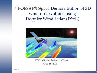
NPOESS P 3 I Space Demonstration of 3D wind observations using Doppler Wind Lidar (DWL). DWL Mission Definition Team April 18, 2005. 21 April 05. General Mission Description.

E N D
NPOESS P3I Space Demonstration of 3D wind observations usingDoppler Wind Lidar (DWL) DWL Mission Definition Team April 18, 2005 21 April 05
General Mission Description • The goal is to obtain global 3D wind observations within the troposphere ( and lower stratosphere) using a Doppler Wind Lidar flown as a P3I on NPOESS. • The initial mission would have two primary objectives: • Demonstrate performance of the first 3D horizontal vector wind sounder in space leading to a fully operational deployment • Demonstrate data utility to civilian and military atmospheric operations and research communities and prepare users for optimal use of the “high impact” wind data • To optimize the return on the mission investment, the instrument would be operated in an adaptive targeting mode. • Synergisms with other NPOESS instruments will be pursued.
Motivation • The NWP communities and the NPOESS program have identified 3D global tropospheric (and stratospheric) winds as having the highest priority as a new observing capability. Global tropospheric winds are NPOESS’s #1 unaccomodated EDR. • Computer modeling studies at NCEP, NASA and ESA show that 3D tropospheric wind profiles are critical to advancing operational forecasting skills. • Cost benefit studies show that global 3D wind observations would have significant cost/safety impacts on aviation (> $100M$/yr), severe weather preparation (evacuation cost avoidance > 100M$/yr) and military operations (>15M$/yr)
The Achievable Instrument • Based upon NASA/NOAA funded studies of several DWL concepts, the mission definition team has selected a dual technology approach for its initial consideration. This approach optimizes the data return given the available platform resources. • The NPOESS P3I wind sounder would include a: • Coherent detection sub-system to provide wind data at cloud tops and within optically thin clouds; in the boundary layer below clear regions and broken cloud decks, aerosols permitting. Primary vertical coverage: boundary layer and cloudy regions up to 20 km • Direct detection sub-system to provide wind profiles above the boundary layer in cloud free (or thin cloud) regions, including the important tropopause region, using the return from molecules in the atmosphere. Primary vertical coverage: clear regions from 3 km to 20 km • The instrument would scan its laser beams in a stepwise fashion, providing both components of the horizontal wind at 1 km intervals above the boundary layer and .25-.5 km within the boundary layer. • The current design concept would require an average of ~350 - 400 watts : the coherent sub-system would be on continuously (~80 watts) and the direct subsystem would operate on a 10% duty cycle (~250 watts average; 850 peak).
NPOESS 3D wind profiler system (dual DWL technologies) Molecular Subsystem Common DWL systems Aerosol Subsystem Dual wavelength Scanner/mirror
The Plan – Adaptive Targeting • Based upon IPO funded studies and the experience of NOAA/NCEP, adaptive targeting will be used in the initial NPOESS mission to maximize the impact of the resources available. • Targets can be identified by several methods including • Pre-launch selection of current data voids • Near real time model-based selection of data sensitive regions • “On-board” detection of targets of opportunity • Given the exploratory nature of the P3I mission, the targeting will be a major component of the data utility evaluation.
DWL Sampling Concept • Measure vertical stack of Target Sample Volumes (TSVs) • Average shots within TSV • Fore and aft perspectives resolve horizontal wind vectors • 2 ground tracks
Adaptive Targeting Adaptive targeting with emphasis on CONUS interests ( Blue is coherent coverage Red is both coherent and direct) Adaptive Targeting Experiments Example of targeting a hurricane as it approaches the Gulf coast. (blue segments: forward looks; Red segments: aft looks; Blue plus red Provide full horizontal wind vector)
Steps to a NPOESS Mission • Prepare to respond to NPOESS for flight opportunities • Develop a detailed mission plan/roadmap • Advance TRLs for critical subsystems • Pursue joint industrial and government participation • Establish partnerships • Develop instrument • Exploratory development phase (e.g. NASA Instrument Incubator Program (IIP)) • Instrument build, test, and demonstration • Airborne DWL testbed to refine instrument design and operations plan and to provide users with precursor data sets • Deliver a space-qualified instrument 18 months before planned launch • Integrate onto NPOESS platform • Operate for a minimum design lifetime of 3 years
Global Wind Data Requirements • NPOESS Integrated Operational Requirements Document (IORD) included P3I wind profile objectives: • IORD I (1996) • IORD II (2001) • Global Tropospheric Wind Sounder (GTWS) acquisition study • Data requirement workshop attended by NASA, NOAA and academia (2001) • WMO requirements are very similar to those vetted within the GTWS workshop • Strategy: use the GTWS threshold requirements for NPOESS P3I mission in adaptively targeted areas.
NPOESS P3I 3D Wind MissionData Requirements GTWS ≤ IORD GTWS ~= IORD 1. Based upon GTWS threshold requirements 2. IORD-II did not identify wind threshold requirements
Requirements (cont’d) GTWS ≤ IORD GTWS ~= IORD
DWLs can meet the requirements • Observing System Simulation Experiments (OSSEs) at NOAA/NCEP and NASA/GSFC have consistently documented improvements in weather forecasts not attainable by current (or improved versions) space-based observing systems • Space-based DWLs provide contiguous profiles of wind shear not achieved by scatterometers, CMV and surface networks. • DWLs can be designed to provide wind observations throughout the troposphere and lower stratosphere, even in the presence of clouds
Why dual technologies? • The three basic DWL options: • Direct detection of molecular motion • Direct detection of aerosol motion • Coherent detection of aerosol motion • Basic direct-only and coherent-only instrument concepts to meet GTWS threshold requirements • Evaluated by NASA’s ISAL and IMDC in 2001 • Resulting instrument size, mass, and power were very large
First proposed in 1995 as WOS/H (Wind Observing Satellite/Hybrid) Capitalizes on the strengths of both technologies Coherent detection probes lower troposphere with high accuracy below clouds and in regions of enhanced aerosols Direct detection provides broad coverage of mid/upper troposphere (+ stratosphere) with modest accuracy Reduces costs Smaller instrument Shared launch; platform; pointing control, data collection, operations Possibly sharing scanner/telescope. Provides redundancy, options for multi-wavelength research and opportunity for synergisms with other platform sensors. Why dual technologies (cont’)
The Dual Technology Advantage • These numbers are for a 400 km orbiting DWL meeting GTWS threshold requirements (at 833km power draw would be ~ 5X greater for the lasers) • Numbers in () indicate hybrid advantage • Coherent (100% duty); Direct (10% duty)
Uses two lidar subsystems One direct detection, the other coherent Complementary measurement properties Direct detection subsystem Detects doppler shift from atmospheric molecules Operates everywhere, 0 to 20 km altitude Provides useful wind observations in cloud free regions Coherent subsystem Meets requirements in regions of high aerosol backscatter (dust layers, clouds, PBL aerosols) The Hybrid Instrument
Why Adaptive Targeting? • As is the case with many observation data sets, only a fraction may be useful for a given objective. Such may be the case for wind observations needed to improve weather forecasts. • NASA and NOAA studies suggest targeted (~ 10-20%) observations of full tropospheric winds could yield impacts close to continuous observations • Given the NPOESS orbit altitude (824 km) and available resources (~ 400 W), the MDT considers adaptive targeting appropriate to both demonstrate highly useful data over limited areas and yield significant global impact.
Primary Targets for Hybrid/AT* • Significant Shear regions • Requires contiguous observations in the vertical. Thus both direct and coherent detection technologies are needed. • Divergent regions • Requires some cross track coverage. Identified by NCEP adaptive targeting scheme(s) • Partly cloudy regions • Requires measurement accuracy weakly dependent upon shot integration (i.e., coherent detection). • Tropics • Tropical cyclones (in particular, hurricanes & typhoons). Requires penetration of high clouds and partly cloudy scenes. *AT: Adaptive Targeting
DWL Technology Readiness • Much of critical technology is mature and ready for space qualification (some subsystems already at Technology Readiness Level 7) • Investments within NASA, NOAA and DoD are in place to move some remaining subsystems to Technology Readiness Level > 5
Technology Readiness (cont’) • Coherent • Demonstrated 1J at 2 microns (LaRC) • Airborne Wind Sounder (IPO and ONR) • Ground-based DWLs (DoD, NASA, NOAA) • Use subsystems developed and tested under SPARCLE initiative • Direct Detection • Subsystem space-heritage in GLAS (altimetry and backscatter) • Ground-based system demonstration (NOAA, NASA)
Summary • Global wind observations are the number one unaccommodated EDR for NPOESS • Combining coherent and direct detection technologies in a hybrid DWL instrument is the best path forward • Adaptive targeting of observations provides the highest level of data utility, given the NPOESS platform resources available to P3I • The Mission Definition Team is looking for partners to provide the instrument build and system integration (NPOESS is to provide the launch, platform support and data communications)