Download
1 / 17
170 likes | 349 Views
Applications of GPS to Shortest Path Algorithms and Automatic Vehicle Location Systems. A Project for FRS 142 – Where’s Waldo? The Science and Application of GPS Wills Sweney 4.5.03.

E N D
Applications of GPS to Shortest Path Algorithms and Automatic Vehicle Location Systems A Project for FRS 142 – Where’s Waldo? The Science and Application of GPS Wills Sweney 4.5.03
Every wonder what the world would be like with little to no congestion, improved safety and efficiency on all roads? Automated Vehicle Location systems and shortest path algorithms are steps in this direction…
Automatic Vehicle Location (AVL) Systems • AVL is an automated vehicle tracking system made possible by navigational technologies such as Global Positioning Systems (GPS) • GPS based systems enable remote tracking of a fleet or vehicle • Modern AVL systems generally include a network of vehicles that are equipped with a mobile radio receiver, a GPS receiver, a GPS modem, and a GPS antenna.
History and Development of AVL Systems • Buried Magnetic Strips • Multi-Lateration • An Odometer-Only system can be used as a stand alone system, which counts wheel revolutions by monitoring flying magnets attached to the front wheels of the vehicle • Signpost-Only Systems: use wayside beacons (signposts) to transmit a unique ID within a given area of effect • The Global Positioning System (GPS): relies on a worldwide network of satellites, but as we know, has problems
Potential Applications of AVL Systems • Public Transit Systems • Disaster Recovery • Law Enforcement • Emergency Management Systems • Traffic Management Systems • Fleet Management Systems
Public Transit Systems • Improve service efficiency • Providing real time information to the travelers regarding the current position of the bus or the transit vehicle at a particular time and the expected arrival and departure time. • Improve information accuracy and availability • Improve radio call management • Improve safety on buses • Improve response times to incidents and emergencies
Disaster Recovery • The GPS-based Automatic Vehicle Location system was used for the first time to manage the debris removal in the disaster recovery setting at the World Trade Center site. • Enabled staff to locate each truck as it loaded materials at the site and transported them to disposal sites • Removing bottlenecks and placing debris removal resources where they were needed at the right time improved efficiency drastically • “Geofence” • Many state and federal agencies have expressed their intent to incorporate this technology into future recovery efforts following such natural disasters as earthquakes, floods, and hurricanes.
Law Enforcement and Medical Response Systems • Law enforcement: providing the dispatcher with the location of the vehicles under his control so that the time required to respond to the calls can be reduced • Providing the information regarding an emergency to the emergency response vehicle can reach the scene in reduced time. • Use of shortest path algorithms to reduce the time cost of any particular route
Traffic and Fleet Management Systems • By locating the stalled vehicles or accident and then providing the information to the other users of the same route so that they can use the alternative routes to avoid the possible delays • Knowing the location of each and every vehicle of the fleet, it can provide the same information to the user of the system so that they can use this information to plan their trip and dynamically change their route
But how do we get there faster, safer, and more efficiently?
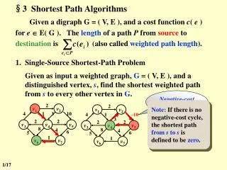
What is a shortest path algorithm? • A shortest path algorithm is a program, or set of directions that can be executed to provide the shortest path between locations given certain conditions and paths • Conditions such as traffic density, speed of travel, and others, as well as geographic obstacles can be factored in to help the algorithm execute and display the shortest path • The latest algorithms being developed adjust to conditions and dynamically execute to give new shortest paths based not only on distance, but also on time
Why do we need shortest path algorithms? • Shortest path algorithms are essential to improving efficiency and safety in many areas network navigation such as highway systems and disaster clean-up • Algorithms are used for determining time dependent shortest paths in highway systems given variations in traffic density • Algorithms are used in connection with GPS tracking technology to provide shortest paths for trucks to follow to specific dumping areas when cleaning up after a natural or terrorism related disaster
Time Dependent Shortest Path Algorithms • Time dependent shortest path algorithms are designed to obtain speed information without integrating GPS into the speedometer • The purpose of the algorithm is to run dynamically with changing traffic conditions and find the shortest time cost path, not necessarily the shortest distance path • In studies done of freeway systems one freeway is assigned as the most congested that way the total traffic load could be distributed among the other routes
Time Dependent Shortest Path Algorithms • An interarrival time: the time between the arrival of a moving object and the next moving object. • The average of this interarrival time represents the severity of the congestion • A skew rate is assigned to create more congestion on a specific route than any other route • For example, if the skew rate is 1, then the traffic is distributed equally among the routes, but if it is equal to 2 then this means that the load is twice as heavy on the assigned most congested route
Time Dependent Shortest Path Algorithms • upon entry into the system a moving object must give it start location, destination, start time, and initial speed • two groups were made, winners and losers. Losers would not be equipped with the algorithm, and the winners would be. Given the start speeds, locations and destination of the two groups, the winners were redirected towards a time dependent shortest path away from the congestion • The losers, staying on the original path only gained from the relief in congestion when the winners left that route. • In the end, the winners won almost all of the time except when the skew = 2 and interarrival rate = 20, the results were very similar
What does it all mean? • Vehicles equipped with shortest path algorithms along with AVL technologies are faster, safer, and more efficient than those without • In the not to distant future most vehicles will be equipped with GPS tracking technology, but the real market change will be in the access and permission to use shortest path algorithms and AVL systems • A current debate is starting on who should be allowed to track, what to track, and access to shortest path algorithms