Download
1 / 34
340 likes | 411 Views
Appropriate Assessment – N2K – Sites of European Importance.

E N D
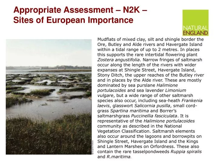
Appropriate Assessment – N2K – Sites of European Importance Mudflats of mixed clay, silt and shingle border the Ore, Butley and Alde rivers and Havergate Island within a tidal range of up to 2 metres. In places this supports the rare intertidal flowering plant Zostera angustifolia. Narrow fringes of saltmarsh occur along the length of the rivers with wider expanses at Shingle Street, Havergate Island, Stony Ditch, the upper reaches of the Butley river and in places by the Alde river. These are mostly dominated by sea purslane Halimione portulacoides and sea lavender Limonium vulgare, but a wide range of other saltmarsh species also occur, including sea-heath Frankenia laevis, glasswort Salicornia pusilla, small cord-grass Spartina maritima and Borrer’s saltmarshgrass Puccinellia fasciculata. It is representative of the Halimione portulacoides community as described in the National Vegetation Classification. Saltmarsh elements also occur around the lagoons and borrowpits on Shingle Street, Havergate Island and the Kings and Lantern Marshes on Orfordness. These also contain the rare tasselpondweeds Ruppia spiralis and R.maritima.
Appropriate Assessment The road to hell ……. …….is paved with good intentions.
Appropriate Assessment – good intentions Policy Rec. 4 Improved access to the countryside, especially for school groups, will be encouraged. Action Rec 6 New accessible hides and visitor centres will be created at Shearer, Given Point and Butt Lane.
Natural England considers that whilst it is not clear that AONB Management Plans set the framework for development they are plans which may well have significant effects (both positive and negative) on sites covered by the Habitats Regulations - Natura 2000 sites.
Significant ? • Significant environmental effects • Effects on the environment which are significant in the context of a plan or programme. Criteria for assessing significance are set out in Annex II of the SEA Directive. [DCLG] • see also Waddenzee judgment paras 47 “ ..where such a plan or project has an effect on that site but is not likely to undermine its conservation objectives, it cannot be considered likely to have a significant effect on the site concerned .“and para 48 ,
It is expected that the bulk of the assessment, of the policies and proposals in the AONB Management Plan, will be a matter of screening for possible negative significant effects on Natura 2000 sites. • Standard matrices are available for this.
A clear audit trail should be evident to prove that the assessment process has been followed alternatives might be provided and where helpful a brief rationale should be provided.
The Bottom Line • Man’t Plans need to be assessed before they can be adopted to ensure that they have no significant environmental effect on N2K sites. Onus is on the AONB partnership / Conservation Boards (the adopters) to demonstrate this, remembering that uncertainty is considered to be a negative effect.
N.B. Condition • Unit detail Shearer Marsh10 Unit area108.71 ha • Feature detail Level 1 feature code H1 Operational feature name COASTLAND BAP habitat category • Current conditionUNFAVOURABLE DECLINING • Assessment date26/11/2004 • Management prognosis Not Meeting Objectives • Reason for adverse condition COASTAL SQUEEZE • Action required EN negotiation/enforcement Other party action . • Assessment comment Unit comprises intertidal mudflat with saltmarsh.'Desktop' examination of EA GIS survey data from 1971-1998* of saltmarsh extent indicates net loss in of saltmarsh. Data indicates there has been some acretion in a few areas but much less overall extent than in 1971. In particular, there is evidence of erosion over many of the marsh edges combined with loss of horizontal extent. *EA, 2000. Saltmarsh change within the Suffolk estuaries between 1971, 1986 and 1998. • Previous conditionAssessment dateConditionManagement prognosis31/08/1999FAVOURABLEMeeting Objectives02/03/1999FAVOURABLEMeeting Objectives
Matrix for each N2K site - summary • Site - Site Name - • Location - Area (ha) • Qualifying features • Key environmental conditions to support site integrity , (SSSI) condition status and trends ( Conservation Objectives) • Possible impacts arising from the AONB Management plan - divided by sector/ theme • Is there a risk of significant effect? (Yes, No, Uncertain) • Possible Impacts from other trends plans and programmes - List all or only most relevant ones • Is there risk of a significant in combination effect? Possible measures to alleviate impact on Natura 2000
Alternatives – modifications • Policy Rec. 4 • Improved access to the countryside, especially for school groups, will be encouraged in appropriate locations. Action Rec 6 A new accessible hide and visitor created will be created at Shearer. [Given Point and Butt Lane.]
Appropriate Assessment - Summary • It is required • Affects policies, plans, proposals – may help in future • Conservation Objectives and condition • Follow the screening approach • Focus on negative or uncertain effects • Be ready to clarify, amend or adopt alternatives • When in doubt consult NE • Show working out if could be contentious • Guidance is available - Cotswolds as a template
AAONB Workshops – Steve Preston – data, information and Monitoring • Special features • Special features • Special features
Data which can be monitored Also placed into context e.g. LCA
Wind farms BWEA ??? Guidance maps • quarries and mineral sites • number of new homes built annually, in the AONB, which are affordable housing • Tranquillity (CPRE maps latest version 2007 - 500m grid • Dark skies - CPRE satellite 80s 90s change • Field sizes and boundaries density - in AONB + landscape types • Defra stats farming outputs - change - finalise and back date as far as poss. • IMD and individual strands - adjusted by rural urban definition and COA ??? • Key landowners/occupiers / NT Water cos - LMG? • Deprived areas • Incomes sectors • Education/qualifications • SOCR stuff - regional context - access to public services Birkbeck data • % change in key employment sectors • Second homes • House prices + affordability - earnings x house prices • Income level; CACI paycheck ? • Neighbourhood stats - local information - context for tens / villages e.g ranking in IMD • Incomes/sectors (significance of land employment sectors) • NOMIS / VAT registered business (CNP report) • ACORN data - simple 5 part categorisation of wealth by postcode (commercially available - NE has copy) • Energy crops etc / take up grants / guidance maps ?
Blanket bog * Joint Character Areas (JCAs) classified by 5 equal intervals using % of National Resource of Blanket Bog
Total Hectares of Blanket Bog • *% of National Resource of Blanket Bog • National Rank for Blanket Bog Presence • North Pennines Rank : 1 Of 31 • Search NBN Gateway...
In Combination • The good news for AONBs • NE advice is that Partnerships and Cons’n Boards should only look at other plans and proposals in combination, if the screening of the Management Plan alone identifies a significant environmental effect If no effect then in combination would not apply
A clear audit trail should be evident to prove that the assessment process has been followed alternatives might be provided and where helpful a brief rationale should be provided.
RecordKey StartDate EndDate DateType TaxonVersionKey taxon name common name taxon authority taxon group name SiteKey SiteName GridReference Projection Precision Recorder Determiner VIRUS VICECOUNTY STAGE DEAD MALE SOURCE ALTITUDE UNSEXED FEMALE ABUNDANCE • 45381 01/01/1985 31/12/1985 Year NHMSYS0000080156 Triturus cristatus Great Crested Newt (Laurenti, 1768) amphibian null JUNIPER BANK RESERVOIR NY989348 OSGB 100 Unknown Unknown Durham Field • 35428 01/01/1983 31/12/1983 Year NHMSYS0000080156 Triturus cristatus Great Crested Newt (Laurenti, 1768) amphibian null MICKLETON POND NY993230 OSGB 100 Unknown Unknown North-west Yorkshire Field • 998 01/01/1983 31/12/1983 Year NHMSYS0000080156 Triturus cristatus Great Crested Newt (Laurenti, 1768) amphibian null MICKLETON POND NY993230 OSGB 100 Unknown Unknown North-west Yorkshire Field • 4379 01/01/1957 31/12/1957 Year NHMSYS0000080156 Triturus cristatus Great Crested Newt (Laurenti, 1768) amphibian null Forest Head NY5857 OSGB 1000 Unknown Unknown Cumberland Field • 35369 01/01/1984 31/12/1984 Year NHMSYS0000080156 Triturus cristatus Great Crested Newt (Laurenti, 1768) amphibian null DOCTORS GATE QUARRY NZ065320 OSGB 100 Unknown Unknown Durham Field • 40996 01/01/1983 31/12/1983 Year NHMSYS0000080156 Triturus cristatus Great Crested Newt (Laurenti, 1768) amphibian null HAMSTERLEY COMMON PIKESTON FELL NZ068321 OSGB 100 Unknown Unknown Durham Field • 1025 01/01/1983 31/12/1983 Year NHMSYS0000080156 Triturus cristatus Great Crested Newt (Laurenti, 1768) amphibian null Hamsterley,Pikeston Fell NZ068321 OSGB 100 Unknown Unknown Durham Field • 1021 01/01/1984 31/12/1984 Year NHMSYS0000080156 Triturus cristatus Great Crested Newt (Laurenti, 1768) amphibian null Doctor's Gate Quarry NZ068321 OSGB 100 Unknown Unknown Durham Field
WES agreements - MAGIC Also CSS, ESA
Data – available, accessible • Information – analysis, intelligence – special qualities • Monitoring – time depth, consistency • Evidence base and credibility – at local, regional and national levels. Man’t plan - USP.
NE Approach • Targeting Agri envt – national context – regional delivery looking to all assets across the scheme objectives. ( =Special qualities?) • Valuation in each objective – additive scores by objective • Climate Change – 4JCAs – valued assets, as per above, plus risk from climate change across those assets. • Methods - Valued assets cf potential.
Spatial distribution of CQC – value x risk Cotswolds AONB – high value x high risk