Download
1 / 33
330 likes | 563 Views
Earth Science 19 Review: Pressure Systems. Review Ch 19 Pressure Systems and the Weather. Earth Science 19 Review: Pressure Systems. Of the various elements of weather and climate, changes in air pressure are the least noticeable.

E N D
Earth Science 19 Review: Pressure Systems Review Ch 19 Pressure Systems and the Weather
Earth Science 19 Review: Pressure Systems • Of the various elements of weather and climate, changes in air pressure are the least noticeable. • Although you might not perceive day-to-day or hour-to-hour changes in air pressure, these changes are very important in producing changes in our weather. • Air pressure is simply the pressure exerted by the weight of the air above. • Average air pressure at sea level is about 1 kilogram per square centimeter. This pressure is roughly the same pressure that is produced by a column of water 10 meters in height.
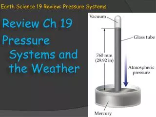
Earth Science 19 Review: Pressure Systems • Air pressure is exerted in all directions; down, up and sideways. • The air pressure pushing down on an object balances against the air pressure pushing up on the same object. • When meteorologists measure atmospheric pressure, they use a unit of measure called millibars. • Standard air pressure is 1013.2 millibars. • A barometer is a device used for measuring air pressure.
Earth Science 19 Review: Pressure Systems • With some modern improvements, the mercury barometer is the standard instrument used today for measuring air pressure. • The need for smaller and more portable instruments for measuring air temperature led to the invention of the aneroid barometer. • The aneroid barometer uses a metal chamber with some air removed. • This partially emptied chamber is very sensitive to variations in air pressure. This chamber changes shape and compresses as the air pressure is increases, and it expands as the air pressure decreases.
ES 19 Review: Wind & Pressure Systems • As important as vertical motion is, far more air moves horizontally, a phenomena called wind. What causes wind however? • Wind is the result of horizontal differences in air pressure. Air flows from areas of high pressure to areas of lower pressure. • The unequal heating of Earth’s surface generates pressure differences. Solar energy is therefore the ultimate source of energy for the creation of wind.
ES 19 Review: Wind & Pressure Systems • If Earth did not rotate and their were no friction what-so-ever between moving air and earth’s surface, air would flow in a straight line from areas of high pressure to areas of low pressure. • But both factors, Earth’s rotation and friction, do exist and the flow of air is therefore not so straightforward. • Three factors combine to control wind: • pressure differences • Coriolis effect • and friction.
ES 19 Review: Wind & Pressure Systems • Wind is created by differences in pressure: the greater these differences are, the greater the wind speed is. • Over Earth’s surface, variations in air pressure are determined from barometric readings taken at hundreds of weather stations. These pressure data readings are shown on a weather map using isobars. • Isobars are lines on a map that connect places of equal air pressure.
ES 19 Review: Wind & Pressure Systems • The spacing of isobars indicates the amount of pressure change over a given distance. • These pressure changes are expressed as the pressure gradient. • A steep pressure gradient, like a steep hill, causes great acceleration (stronger winds) of a parcel of air. • A less steep gradient causes a slower acceleration (milder winds).
ES 19 Review: Wind & Pressure Systems • The pressure gradient is the driving force of wind. • The pressure gradient has both magnitude(wind strength) and direction. • It’s magnitude is reflected in the spacing of the isobars. The closer the spacing, the stronger the winds. • The direction of wind force is always going from • areas of high pressure • to areas of low pressure • and at right angles to the isobars.
ES 19 Review: Wind & Pressure Systems • The weather map at right shows typical air movements associated with high and low pressure systems. • Air moves out of regions of higher pressure and into the regions of lower pressure. • However, wind does not cross the isobars at right angles as one would expect. • This change in rotation results from the rotation of the Earth and is called the Coriolis effect.
ES 19 Review: Wind & Pressure Systems • The Coriolis effect describes how Earth’s rotation affects moving objects. • All free-moving objects or fluids, including the wind, are deflected to the right of their path of motion in the Northern Hemisphere. • In the Southern hemisphere, they are deflected to the left.
ES 19 Review: Wind & Pressure Systems • Imagine the path of a rocket launched from the North Pole toward a target located at the equator. • The true path of the rocket is straight, however, • in the time it would take for the rocket to fly from the North pole to the equator, • the Earth would have rotated underneath the rocket by 15 degrees. • The rocket arrives at a spot to the left of where it was intended because the Earth moved under it while it flew. • The counterclockwise rotation of the Northern hemisphere causes this path to deflect.
ES 19 Review: Wind & Pressure Systems • This apparent shift in direction is attributed to the Coriolis effect. • This deflection • Is always directed at right angles to the direction of airflow • Affects only wind direction and not wind speed • Is affected by wind speed; the greater the wind speed the greater the amount of deflection • Is strongest at the poles and weakens toward the equator, becoming nonexistant at the equator
ES 19 Review: Wind & Pressure Systems • Now, consider that the amount of deflection in a new direction is affected by wind speed (the greater the wind speed the greater the amount of deflection) ; anything that slows the speed of the wind also affects it’s direction. • This is where the difference in the altitude of the wind currents play a role. Currents that are high in the atmosphere, such as the jet streams, do not encounter resistance. • Wind currents that are close to the ground however may be slowed down by friction from objects such as mountains and hills.
ES 19 Review: Wind & Pressure Systems • The pressure gradient (PGF) and Coriolis effect (CF) balance in high-altitude air, and wind generally flows parallel to isobars. • For air close to Earth’s surface , the roughness of the terrain determines the angle of airflow across the isobars. • Over the smooth ocean surface, friction is low, and the angle of airflow change is small. • Over rugged mountain terrain however, where friction is higher, winds move more slowly and cross the isobars at a change in angle. • Friction causes winds to flow across the isobars at angles as great as 45 degrees. • Slower wind speeds caused by this friction decreases the Coriolis effect and thereby affects the wind direction.
ES 19 Review: Wind & Pressure Systems • Pressure centers are among the most common features on any weather map. By knowing just a few basic facts about centers of high and low pressure, you can increase your understanding of present and upcoming weather. • Lows, or cyclones, are centers of low pressure. • Highs , or anticyclones, are centers of high pressure. • In cyclones, lows, the pressure decreases from the outer isobars toward the center. • In anticyclones, highs, just the opposite is the case: the values of the isobars increase from the outside toward the center.
ES 19 Review: Wind & Pressure Systems • Winds move from higher pressure to lower pressure areas and are deflected to the right or left by the Earth’s rotation. • When the pressure gradient and the Coriolis effect are applied to pressure centers in the Northern Hemisphere; • winds blow counterclockwise around the low. • Around a high, the winds blow clockwise.
ES 19 Review: Wind & Pressure Systems • In the Southern Hemisphere, the Coriolis effect deflects the winds to the left. • Therefore, the winds around a low, south of the equator, move clockwise while the winds around a high blow counterclockwise. • In either hemisphere, friction causes a net flow of air inward around a cyclone and a net flow of air outward around an anticyclone.
ES 19 Review: Wind & Pressure Systems • Rising air is associated with cloud formation and precipitation, whereas sinking air produces clear skies. • Imagine a low pressure surface system where the air is spiraling inward. • Here the net inward movement of air causes the area occupied by the air to shrink; a process called horizontal convergence. • When air converges (comes together) horizontally, it must increase in height to allow for the decreased area it now occupies. • This increase in height produces a heavier and taller column of air.
ES 19 Review: Wind & Pressure Systems • In order for a surface low to exist for very long, converging air at the surface must be balanced by outflows aloft. • For example, surface convergence could be maintained if divergence, or spreading out of air aloft, occurs at an equal rate. (as in the cyclone at right) • The figure at right shows the relationship between surface convergence (inflow), uplift of the air, and divergence aloft in the cyclonic flow of low pressure system. • .
ES 19 Review: Wind & Pressure Systems • Lows move in roughly west to east direction across the United States, and require a few days (often up to a week0 for the journey across the country. • The paths of lows can be unpredictable and making accurate calculations as to their movements can be a chore. • Before surface conditions can be linked to the conditions of air higher up, it is important for us to understand the circulation patterns of the total atmosphere.
ES 19 Review: Wind & Pressure Systems • The underlying cause of the wind is the unequal heating of Earth’s surface. • In tropical regions, more solar radiation is received than is radiated back into space. In regions near the poles the opposite is true; less solar energy is received than is lost. • The atmosphere balances these differences on a global scale by acting as a giant heat-transfer system. • This system moves warm air toward high latitudes and cool air toward the equator.
ES 19 Review: Wind & Pressure Systems • The figure at right shows three sets of cells that carry out this function; the Polar cell, Ferrel cell, and Hadley cell. • Near the equator, rising air produces a pressure zone known as the equatorial low; a region characterized by abundant precipitation (heavy rain). • As we see in the figure at right, the upper level flow from the equatorial low reaches about 20 to 30 degrees latitude (about the Tropic of Cancer or Capricorn) and than sinks back toward the surface in a loop called the Hadley cell.
ES 19 Review: Wind & Pressure Systems • The sinking of air, and it’s associated heating due to compression, produce hot dry conditions. • The center of this zone of sinking dry air is the subtropical high around 30 degrees north and south latitude; areas known as the Tropic of Cancer and Tropic of Capricorn. • The great deserts of Australia, Arabia, and North Africa exist because of this stable dry air system associated with sub-tropical highs.
ES 19 Review: Wind & Pressure Systems • At the surface, airflow moves outward from the center of the subtropical high. • Some of the air travels toward the equator and is deflected by the Coriolis effect, producing the trade winds. • Trade winds are two belts of winds that blow almost constantly from easterly directions. • The trade winds are located between the subtropical highs and the equator.
ES 19 Review: Wind & Pressure Systems • The remainder of the air travels toward the poles and is deflected, generating the prevailing westerlies of the middle latitudes. • The westerlies make up the dominant wet-to-east motion of the atmosphere that characterizes the regions on the polarward side of the subtropical highs. • As the westerlies move toward the poles, they encounter the cool polar easterlies in the region of the Polar cells (subpolar lows).
ES 19 Review: Wind & Pressure Systems • Circulation in the middle latitudes is complex. • Between 30 and 60 degrees latitude, the general west to east flow, known as the “westerlies”, is interrupted by migrating cyclones (Lows) and anticyclones (Highs). • In the Northern hemisphere, these pressure cells move from west to east around the globe. ________________________________ • On a regional level, small-scale winds produced by locally generated pressure gradient are known as local winds. • The local winds are caused by either topographic effects (such as mountains) or by variations to the surface composition (land or water). • . 4 types local wind patterns
ES 19 Review: Wind & Pressure Systems • In coastal areas during the warm summer months, the land surface is heated more intensely during the daylight hours than an adjacent body of water is heated. • As a result, the air above the land surface heats more, expands and rises; creating an area of lower pressure. • A sea breeze than develops because the cooler air over the water at higher pressure moves toward the land to fill in the low pressure area. • This breeze starts developing shortly before noon and generally reaches it’s greatest intensity during the mid to late afternoon. • These relatively cool winds can have a moderating influence on afternoon temperatures in coastal areas.
ES 19 Review: Wind & Pressure Systems • At night, the reverse may take place. • The land cools more rapidly than the sea, and a land breeze develops. • The cooler air, at high pressure over the land, moves to the sea, where the air is warmer and at a lower pressure. • Small scale breezes can also develop along the shores of large lakes. • People who live in cities along the Great Lakes, such as Chicago, recognize the lake effects of winds. • This is why their will be cooler temperatures along the shores of the lakes in the summertime as breezes off the water bring heat relief.
ES 19 Review: Wind & Pressure Systems • A daily wind similar to land and ocean breezes occurs in many mountainous regions. • During daylight hours, the air along the slopes of mountains is heated more intensely than the air at the same elevation over the valley floor. • Because this warmer air on the mountain slope is less dense, it glides up along the slope and generates a valley breeze. • The occurrence of these daytime upslope breezes can often be identified by the cumulus clouds that develop on adjacent mountain peaks.
ES 19 Review: Wind & Pressure Systems • After sunset, the pattern may reverse. • The rapid cooling of the air along the mountain slopes produces a layer of cooler air next to the ground. • Because cooler air is denser than warmer air, it moves downslope into the valley. • Such a movement of air is called a mountain breeze. • In the Grand canyon at night, the sound of cool air rushing down the sides of the canyon at night can be louder than the sound of the Colorado River running.
ES 19 Review: Wind & Pressure Systems • The same type of air drainage can be found in places that have slopes less steep. • The result is that the coldest pockets of air are usually found in the lowest spots. • Like many other winds, mountain and valley breezes have seasonal preferences; they happen more at certain times of the year. • Although valley breezes are most common in the warmer seasons when solar heating is most intense, mountain breezes tend to be more dominant in the colder weather seasons.