Download
1 / 20
200 likes | 399 Views
Secretary International Steering Committee for Global Mapping MAY, 2006. Global Map -as a base of utilization of Global Earth Observation Data-. What is Global Map. Digital geographic dataset of Global coverage Consistent specifications Worldwide open distribution Expected application:

E N D
Secretary International Steering Committee for Global Mapping MAY, 2006 Global Map -as a base of utilization of Global Earth Observation Data-
What is Global Map • Digital geographic dataset of • Global coverage • Consistent specifications • Worldwide open distribution • Expected application: • Analyses for solving global environmental problems • Monitoring activities for environmental change at global level iscgm.org
Who is making Global Map • NMOs (National Mapping Organizations) are assumed to make Global Map for their countries • Support scheme available for those who are difficult in making Global Map by themselves • Global Map are open to public through the Web (www.iscgm.org) • International Steering Committee for Global Mapping (ISCGM) • 20 members incl. Heads of 17 • Chair: Prof. D.R.F Taylor (Carlton Univ., Canada) • Secretariat: Geographical Survey Institute (GSI), Ministry of Land, Infrastructure and Transport (MLIT), Government of Japan iscgm.org
History of Global Mapping • 1992 UNCED • Adoption of “Agenda 21” Global Mapping Concept proposed by Japanese Government • 1996Establishment of International Steering Committee • 1997 Rio+5(UN General Assembly Special Session) • necessity of Global Mapping included in the adopted “Programme for the further implementation of Agenda 21” • 2000 Release of Global Map through the Internet • 2002 WSSD • Adopted “Plan of Implementation” called for initiatives and partnerships for global mapping • 2007 Whole land of the Earth to be covered by Global Map iscgm.org
Implementation Plan of WSSD 132. Promote the development and wider use of earth observation technologies, including satellite remote sensing, global mapping and geographic information systems, to collect quality data on environmental impacts, land use and land-use changes, including through urgent actions at all levels to: (a) Strengthen cooperation and coordination among global observing systems and research programmes for integrated global observations, taking into account the need for building capacity and sharing of data from ground-based observations, satellite remote sensing and other sources among all countries; (b) Develop information systems that make the sharing of valuable data possible, including the active exchange of Earth observation data; (c) Encourage initiatives and partnerships for global mapping. iscgm.org
Implementation Plan of WSSD 133. Support countries, particularly developing countries, in their national efforts to: (a) Collect data that are accurate, long-term, consistent and reliable; (b) Use satellite and remote-sensing technologies for data collection and further improvement of ground-based observations; (c) Access, explore and use geographic information by utilizing the technologies of satellite remote sensing, satellite global positioning, mapping and geographic information systems. iscgm.org
Current Status of Global Mapping • 146 countries and 15 regions participate(91% of the global land area coverage) • 22 countries(14% of the global land area coverage) already released Global Map • 2000: Japan, Lao P. D. R., Nepal, Sri Lanka, Thailand, • 2001: Australia, Bangladesh, Colombia, Mongolia, Philippines. • 2002: Panama, Kenya • 2003: Burkina Faso, Kazakhstan, Kyrgyz, Mexico, Myanmar • 2004: Swaziland, Samoa • 2005: Iran, Macedonia ※ With data for verification phase(81 countries and regions), 61% of the global land are being covered. iscgm.org
Progress of Global Mapping Project iscgm.org
Global Map Specifications • Spatial resolution: 1km (equivalent to 1:1,000,000 scale) • 8 layers • Vector data(point, line, area) Boundaries(Administrative/Coast),Drainage(Rivers/Lakes),Transportation(Roads/Railways/Airport),Population centers • Raster data(grid) Elevation, Land Cover, Land Use, Vegetation iscgm.org
Global Map Data(Vector Data) Boundaries Drainage Administrative, Coast Rivers, Lakes, Dams Transportation Population Centers Roads, Railways, Airports Locality and Name of Cities iscgm.org
Global Map Data (Raster Data) Elevation Land Cover Information at 1m step 17 categories Land Use Vegetations 9 categories 20 categories iscgm.org
Nepal 2 Global Map Screenshot(Nepal) Kathmandu カトマンズ ● Boundaries, Vegitations From ESE Horizontal-Vertical Ratio 1:10 iscgm.org
Kazakhstan Global Map Screenshot(Kazakhstan) Vector data iscgm.org
How to get Global Map • Downloading from ISCGM Website • Open Download Service Page Register User Information • Download Data and/or Viewer Soft • Extract Data, Open with the Viewer iscgm.org
Download user information • Download registration: • 171 countries, 10,261 persons(as of Mar. 2006) • 50.5% is from JAPAN(5,183 persons) Best 20 of other domains USA 930 Korea Republic 425 Australia 348 UK 231 Mexico 153 Korea D.P.R 141 Brazil 134 Germany 134 Venezuela 133 Canada 132 China 115 Thailand 108 Spain 106 Italy 80 France 75 India 65 Philippines 65 Colombia 62 Bangladesh 59 Argentina 58 Monthly Registration 00 2001 2002 2003 2004 2004 06 iscgm.org
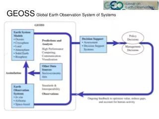
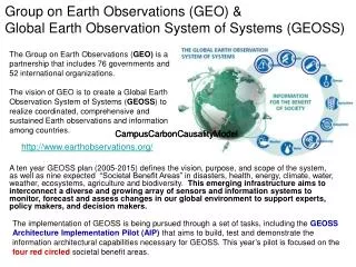
Relation between Earth Observation and GM • Activities in Earth Observation Community • Close relation with CEOS/WGISS from 1998 • Global Mapping is registered as WSSD Partnership in which ISCGM and CEOS are involved • CEOS WSSD Follow-up Module5 is “Global Mapping, Land-use Monitoring and GIS“ • Participation in GEO activities • GM and EO are mutually dependent • Benefits of Global Map in Earth Observation iscgm.org
Benefits of Global Map in Earth Observation • :Platform for Spatial Data Analysis • Common Geographic Datasets to be available in each country, including Developing Countries • Avoid duplicated investments in making Geographic Datasets. • :Integrate Physical and Socio-Economic data • Global Map links physical data with socio-economic data, leading to value-added application of earth observations. iscgm.org
Benefits of Global Map in Earth Observation Physical Data Socio-Economic data Ground observation (climate etc.) Statistics (economy, population) Satellite data(soil, water quality, etc.) Non statistical Information Global Map (as platform data for spatial data analyses) iscgm.org
New Charenge of ISCGM • GLCNMO (Global Land Cover by National Mapping Organizations) • Project of Global Land Cover Data Development • It is implemented in collaboration with NMOs of GM community • MODIS data in 2003 are used as classification source data • Landsat data are used as ground truth data • Ground truth DB are also developed • Development by 2007 iscgm.org
Future of Global Map and EO GM Future : • Completion of data development by 2007 (Target set in the document of WSSD Partnership) • Update approximately every 5 years • Base of integration for EO data CEOS/WGISS is important partner of GM to attain goals described above Thank you ! iscgm.org