Download
1 / 22
230 likes | 396 Views
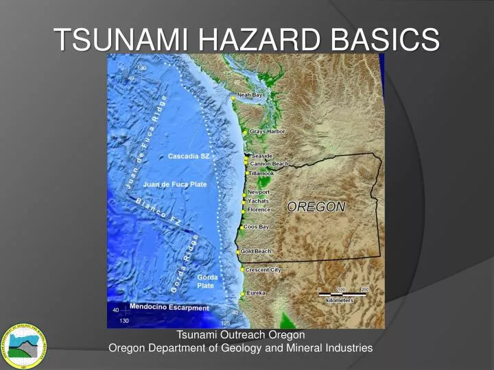
TSUNAMI HAZARD BASICS. Tsunami Outreach Oregon Oregon Department of Geology and Mineral Industries . Earthquake Sources for Tsunamis . Local Oregon Tsunamis. Distant Tsunamis. Map modified from NOAA website: http:// celebrating200years.noaa.gov/magazine/dart_buoys/ring_of_fire.html.

E N D
TSUNAMI HAZARD BASICS Tsunami Outreach OregonOregon Department of Geology and Mineral Industries
Earthquake Sources for Tsunamis Local Oregon Tsunamis Distant Tsunamis Map modified from NOAA website: http://celebrating200years.noaa.gov/magazine/dart_buoys/ring_of_fire.html
Plate Tectonic Map of the Pacific Northwest – the “Cascadia” Region Taken from 2010 issue of Cascadia, Oregon Dept. of Geology and Mineral Industries
Animations from: http://records.viu.ca/~earles/1700quake/1700p6.htm
Local Cascadia Tsunami Arrives in minutes Animation from http://www.oregongeology.org/sub/earthquakes/Coastal/TsunamiMovie.htm and originally produced by the Oregon Graduate Institute of Science & Technology (now affiliated with Oregon Health and Sciences University)
Tsunami Wave Appearance Source: www.waveofdestruction.org • A tsunami wave crest has three general appearances from shore: • Fast-rising tide • Cresting wave • A step-like change in the water level that advances rapidly (called a bore) A bore on the Qian Tang Jiang River, China • Series of waves • Most tsunamis come in a series of waves that may last for several hours • The outflow of water back to the sea between waves can cause more damage than the original incoming wave fronts • The first wave may not be the largest • Water rises from the beginning = leading elevation wave • Water withdraws from the beginning = leading depression wave • This slide is modified from http://earth.esa.int/workshops/polinsar2007/presentations/38_boerner.pdf
How big will the “Big One” be from Cascadia? Turbiditesreveal what actually happened over the last 10,000 years.(Illustration below is modified from Goldfinger et al. (in press) by adding magnitude estimates and some labels) • 20 full length or nearly full length ruptures. • 2 to 3 ruptures of ~75% of the length of the margin. • 19 shorter ruptures in the southern part of the margin. Mw ~9500 yrs Mw 8.5-8.8430 yrs Mw 8.5-8.3320 yrs Mw 7.6-8.4240 yrs
Turbidites in a deep sea core. (picture provided by Chris Goldfinger, 2010) Taken from Atwater (2005) Deep Sea Clay Turbidite Sand
Distant Tsunami • Arrives 4 + hours after the earthquake • Lower damage and flooding than local tsunamis • National Tsunami Warning System can warn you
Nearest Distant Tsunami Source is Alaska1964 Alaska Tsunami – Arrived in ~4 hrs Map is from http://www.ngdc.noaa.gov/hazard/icons/1964_0328.jpg
The “Big One” from a distant source already happened! Great Alaskan Earthquake of 1964 was a magnitude 9.2. Tsunami run-up in Oregon was generally ≤ 20 ft at the open coast. Figure from Schatz et al. (1964)
Local Tsunami • Arrives minutes after the earthquake • Much higher waves • Much further inland penetration • NOAA Tsunami Warning System ineffective • Earthquake = Only Warning
Source of picture: http://www.usc.edu/dept/tsunamis/2005/tsunamis Port Damage at Banda Aceh
Inundation Map: Possible Cascadia Tsunamis Elementary school Cannon Beach, Oregon City Hall 50% confidence Fire Station 80% 90% 95% 99%
Tsunami Waves Arrive for Hours for both Distant and Local Tsunamis • Many waves • 4-5 hours of big waves • 8-10 hours of significant waves Time history is from Priest and others (2003) for Cascadia tsunami wave arrivals at the mouth of the Alsea Bay near Waldport, Oregon. Hrs.
Tsunami Deposits Record - Frequency - Relative size 1964 Core Site 1960 Distant Tsunamis 260 yrsnotsunamisand! Crescent Beach Motel, 1964 Jan.26,1700 Local Cascadia Tsunami Crescent City 1964 Alaska Tsunami Inundation Photos provided by Lori Dengler, Humboldt State University
CANNON BEACH , OREGONEVACUATION MAP Map downloaded from: http://www.oregontsunami.org
Oregon Tsunami Evacuation Map Viewer http://www.oregontsunami.org
FINAL MESSAGEIf you feel a strong earthquake at the coast, get to high ground as fast as you can.DO NOT wait around for any other warning! DO NOT go back to the evacuation zone until local officials say it is okay.