Download
1 / 13
130 likes | 287 Views
The Adaptive Sampling and Prediction (ASAP) Program. A multi-disciplinary University research initiative sponsored by the United States Department of Defense. ASAP Overall Goal.

E N D
The Adaptive Sampling and Prediction (ASAP) Program A multi-disciplinary University research initiative sponsored by the United States Department of Defense.
ASAP Overall Goal Learn how to deploy, direct, and utilize autonomous vehicles and other mobile sensor platforms most efficiently to sample the ocean, assimilate the data into numerical models in real or near-real time, and predict future conditions with minimal error.
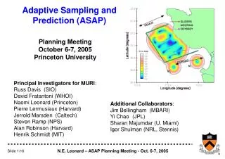
The Players • Princeton University • Control Theory, Adaptive Sampling • Naval Postgraduate School • Manned and Unmanned Aircraft, Real-Time Bottom Moorings • Harvard University • Numerical Modeling and Prediction • Massachusetts Institute of Technology • Odyssey AUVs, Acoustic Data Assimilation (ADA) • Woods Hole Oceanographic Institution • Shallow Water Gliders • Scripps Institution of Oceanography • Deep Water Gliders • California Institute of Technology • Lagrangian Coherent Structures • National Research Council (Canada) • Vehicle Control, Adaptive Sampling
Adaptive Sampling Ingredients Mobile sensor platforms (vehicles): • Underwater gliders (SIO=4, WHOI=5, Canada=?) • Propeller-driven AUVs (MIT=2, NPS=2, MBARI=1?, CalPoly=?) • Research aircraft (NPS) • Ships Quantitative sampling metrics: • Maximize broad-area coverage (minimize OA error) • Maximize sampling of significant dynamics (eg, via feature tracking) • Minimize model uncertainty
Combining the Ingredients: Strawman Allocation Simple approach to heterogeneous fleet: • Associate each kind of vehicle with a metric (or possibly two). • Make association so that vehicle capabilities are good match with scales addressed by metric. 1. Maximize broad-area coverage • Underwater gliders • Airplanes 2. Maximize sampling of significant dynamics • Propeller-driven vehicles • Ships 3. Minimize model uncertainty • Propeller-driven vehicles • Ships • Others?
Unifying Science Goal: Construct a volume and heat budget for the three-dimensional upwelling center off Point Ano Nuevo during upwelling, relaxation and transition events. ~
ASAP POSSIBLE SAMPLING PLAN B
Observing the Terms (a slide in progress) ?
Potential Collaborations • Monterey Bay Aquarium Research Institute (MBARI) • Facilities Support • DURADO AUVs (Bellingham et al.) • M-Buoys (Chavez et al.) • Profiling Moorings? • MARS Cable? • Assessing the Effects of Submesoscale Ocean Parameterizations (AESOP) • Enhanced / Longer Flights (Jessup et al.) • Dye Release Experiment (Barth et al.) • Persistent Littoral Undersea Surveillance (PLUS) • Still in the call for proposals stage • Innovative Naval Prototypes (INP)
Potential Collaborations (con’t) • Northern California Coastal Ocean Circulation Monitoring Program (COCMP) (Cal. Prop. 40) • Expanded CODAR network (Paduan, Garfield) • Infrastructure / people support • Center for Innovative Marine Technologies (CIMT) • CIMT buoy • HF radar network support • Infrastructure / people support (Rosenfeld, Paduan, staff) • Layered Organization of the Coastal Ocean (LOCO) • Biological Thin Layers (McManus, Donahue, Holiday, et al.) • Field program 2005, NW corner of the bay • Partnership for Interdisciplinary Studies of Coastal Oceans (PISCO) • Shallow water ADCP network • Infrastructure / people support
Potential Collaborations (con’t) • Ultra-Wide Aperture Array Gain (UWAAG DRI) • Curtin Leads • Nonlinear Internal Wave Iniative (NLIWI) • New Jersey ‘06 • South China Sea ‘07 • Distributed Sensors (DASEE) • Distributed ASW Sensor Employment and Evolution • DURIP • Great way to buy instrumentation • Proposals due August • NSF/ALPS • DARPA
NORTHERN CALIFORNIA Coastal Ocean Circulation Monitoring Program