Download
1 / 26
280 likes | 1.17k Views
Continental Margins and Ocean Basins. Bathymetry. February 2000 a map of the surface of our planetary neighbor mars was completed. Bathymetry: is the discovery and study of our ocean floor. (Bathy= deep, Meter = measure).

E N D
Bathymetry • February 2000 a map of the surface of our planetary neighbor mars was completed. • Bathymetry: is the discovery and study of our ocean floor. (Bathy=deep, Meter= measure). • The earliest known bathymetry studies were carried out in the Mediterranean by a Greek named Posidonius in 85 B.C. • he tied a rope that was 2 kilometers to a stone and let it down until the stone touched the bottom.
Bathymetry • Sir James Clark Ross South obtained soundings of 4,893 meters in Atlantic in 1818. • The Challenger crew made 492 bottom soundings and confirmed Matthew Maury’s earlier discovery of the Mid-Atlantic Ridge.
Echo Sounding • Reginald A. Fessenden • developed the Echo Depth Sounder • directed a powerful sound pulse ahead of the ship & listened for echo from submerged portion of iceberg • The USS Stewart a U.S Navy Vessel made 14 profiles using an echo sounder from 1925-1927. • A comprehensive sounder track chart was made by 1959.
Echo Sounding • Multi Beam Systems • bounces sound off the seafloor to measure the ocean depth. • A pulse of sound of energy is sent toward the seabed every 10 seconds. • may have as many as 121 beams radiating from the ship’s hull. • With that researchers can build a complete map of the area they are testing.
Satellite Altimetry • Satellite can measure small variations in elevation of surface water can’t measure ocean depth directly • uses about 1000 radar pulses each second • Researchers have found that the ocean surface can vary from smooth shape by as much as 200 meters. (because of the pull of gravity) • An undersea mountain or ridge “pulls” water toward it from the sides forming a mound of water over itself.
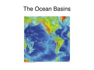
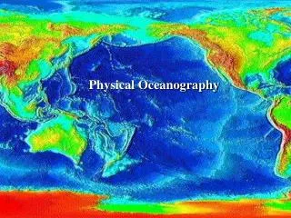
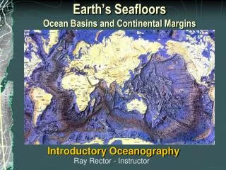
Topography of the Ocean Floor • Earth’s surface is not a static arrangement of continents and ocean, but a dynamic mosaic of jostling lithospheric plates. • The lighter continental lithosphere floats in isostatic equilibrium above the level of the heavier ones. • Continental crust is thicker than oceanic crust; continental lithosphere is less dense than oceanic lithosphere.
Topography of the Ocean Floor • Near shore the features of the ocean floor are similar to those of the adjacent continents. ( they share the same granitic basement.) • Continental margin: the submerged outer edge of a continent • Ocean basin: deep seafloor beyond the continental margin.
Continental Margins • Continental margins facing the edges of divergingplates are called passive margins also known as Atlantic-type margins • Continental margins near the edges of the of converging plates are called activemargins also know as Pacific-type margins
Continental Margins • Three main divisions: • continental shelf: shallow, nearly flat, close to shore • continental slope: seaward, more steeply sloped • continental rise: blends the continental margins into deep sea basins
Continental Shelves • Def: the shallow, submerged extension of a continent • Underlain by granite continental crust • Area of shelf is 74% o earth’s area • Most of material that makes up shelf comes from erosion of continental mass • Width of shelf is usually determined by its proximity to a plate boundary
Continental Slope • Def: the transition between the gently descending continental shelf and the deep-ocean floor • Slopes are formed of sediments that reach the built-out edge of the shelf and are transported over the side • Inclination of a typical slope is about 4 degrees • Slopes average about 12 mi. wide and end at continental rise • Shelf break marks the abrupt transition from continental shelf to slope
Continental Rises • def: an apron of accumulated sediment • sediments from the cont. shelf slowly descend to ocean floor along the whole cont. slope • most sediments that form are transported by turbidity currents • Deep boundary currents held against the con. Slopes by the Coriolis effect pick up volcanic debris and sediments transported by turbidity currents and sweep them along the ocean floor
Submarine Canyons • Submarine canyons cut into the con. Shelf and slope, often terminating on the deep-sea floor in a fan-shaped wedge of sediment • canyons generally trend at right angles to the shoreline, sometimes beginning very close to the shore • epicenter is the point on the surface of earth directly above the focus of an earthquake • turbidity currents are avalanche-like sediments movements • turbidity currents are caused when turbulence mixes sediments into water above a sloping bottom
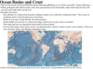
Deep-Ocean Basins • Consists of oceanic ridge systems and adjacent sediment-covered plains. • May be rimmed by trenches or masses of sediments. • Flat expanses are interrupted by islands, hills, active & extinct volcanoes, and active zones of seafloor spreading. • Sediments reflect the history of the surrounding continents, biological productivity of the water & the age of the basins.
Oceanic Ridges • Oceanic Ridges- chain of mountains of young basaltic rock at the active spreading center of an ocean • devoid of sediments • rise about 2km above seafloor • may form islands • account for 22% of the world’s solid surface area
Oceanic Ridges • associated with rift zones • widest & youngest where most active • EXAMPLE= Mid-Atlantic Ridge • Transform Faults- plane along which rock masses slide horizontally past one another • Offsets the Mid-Atlantic Ridge in almost regular intervals • Earthquakes are common • Fracture Zones- area of irregular, seismically inactive areas that show evidence of once-active transform faults
Hydrothermal Vents • Hydrothermal Vents- spring of hot, mineral- & gas-rich seawater found on some oceanic ridges in zones of active seafloor spreading • Black smokers- water descends through fissures & cracks in ridge floor, comes in contact with very hot rocks (assoc. with active seafloor spreading), superheated & chemically active water dissolves minerals & gases, escapes upwards through vents b/c of convection
Abyssal Plains & Abyssal Hills • Abyssal Plains- flat, featureless expanses of sediment covered ocean floor • Most common in Atlantic & Rare in Pacific • Lie between oceanic ridges & continental margins • Sediments mostly from shallow-water origins • Abyssal Hills- small, sediment-covered extinct volcanoes or intrusions of once-molten rock (< 200 meters or < 650 feet) • Associated with seafloor spreading • almost all the area of the deep-ocean floor not part of oceanic ridge system
Seamounts & Guyots • Seamounts • volcanic projections that don’t rise above sea surface • Guyots • flat-top seamounts once tall enough to approach/penetrate sea surface
Trenches & Island Arcs • Trenches- arc-shape depression in deep-ocean floor • Occur where converging oceanic plate is subducted • Among Most active geological feature on earth • Earthquakes & tsunamis often originate in trenches • Deepest places in earth’s crust • Mariana Trench- Pacific ocean • Curving chains of V-shaped indentions
Trenches & Island Arcs • Island Arcs- curving chain of volcanic islands and seamounts • Almost always parallel to concave edges of trenches • Formed by tectonic & volcanic activity associated with subduction • Aleutian Islands, Mariana Islands, & most Caribbean Islands