Download
1 / 15
160 likes | 337 Views
Support to Aviation Control Service. Monitoring of volcanic SO2 and ash emissions from satellite. Jos van Geffen , Michel Van Roozendael, Sofie Delanoye, Isabelle De Smedt, Caroline Fayt (BIRA-IASB) Walter Di Nicolantonio, Giovanni Ballista, Alessandra Cacciari (CGS)

E N D
Support to Aviation Control Service Monitoring of volcanic SO2 andash emissions from satellite Jos van Geffen, Michel Van Roozendael, Sofie Delanoye, Isabelle De Smedt, Caroline Fayt (BIRA-IASB) Walter Di Nicolantonio, Giovanni Ballista, Alessandra Cacciari (CGS) Pieter Valks, Meike Rix, Diego Loyola, Thilo Erbetseder, Cordelia Maerker (DLR) Ronald van der A, Rob Roebeling, Paul de Valk (KNMI) USEReST workshop – 11-14 November2008 Naples, Italy
Contents • Background and aim of the Service • Examples • Concluding remarks Eruption of the Grímsvötn volcano on Iceland in November 2004. (Photo Matthew J. Roberts)
Rationale of the service • Hazard to aviation of volcanic clouds: • Ash (major): clogs censors, melts in engines, etc. • SO2: corrosive (very little known about this). • More than 90 aircraft damaged by ash clouds: • At least 7 cases of in-flight loss of power. • Three 747’s temporarily lost power on all four engines (Indonesia 1982, Alaska 1989). • Pinatubo (1991): aircraft damaged >1000 km. • Per year about 10 eruptions reach flight levels. • Economic cost estimation of US$ 250 Million during 1982-2000. Avoidance of ash clouds is the only safe procedure for aircraft !! Damage to Boeing-747 engine. (Photo: Eric Moody, BA)
Volcanic Ash Advisory Centres Volcanic Ash Advisory Centres (VAACs) are the official organisations charged with gathering information on volcanic ash clouds and, on the basis of that, issue advices and alerts to air line and air traffic control organisations on the possible danger of volcanic clouds. The VAACs are part of an international system set up by the International Civil Aviation Organization (ICAO) called the International Airways Volcano Watch (IAVW), which was founded at an ICAO meeting in 1995. VAAC responsibilities to aviation users include: • Utilise satellite data, pilot reports, etc. to detect and track ash clouds. • Use trajectory/dispersion models to forecast the motion of ash plumes.
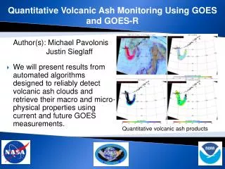
Aim of the service The aim of the Support to Aviation Control Service (SACS) is to deliver in near-real time data derived from satellite measurements regarding emissions of SO2 (from measurements by SCIAMACHY, OMI and GOME-2) and aerosols (from SEVIRI) possibly related to volcanic eruptions, and where possible to track volcanic plumes. Notifications of “SO2 events” and data from SACS can assist the VAACs and other interested users: volcanic observatories, air quality monitoring institutes, scientist, etc. Link with GlobVolcano and volcanological community. Currently: 40 subscribers Alaid, Russia, April 1981 (Photo: Smithsonian GVP)
Tungurahua (Ecuador) – 6 Feb. 2008 On 6 Feb. 2008 the Tungurahua volcano in Ecuador erupted. Ash emissions reached 15 km altitude south of the volcano, and 9 km altitude 225 km NW of the volcano. Tungurahua (summit: 5 km) lies some 130 km south of the town Quito. The eruptions killed five people and made about 20.000 hectare of agricultural ground infertile. Several thousand people were evacuated. Tungurahua has been active since 1999, when it erupted for the first time in 80 years. On 6 Feb. SACS issued an alert email of an “SO2 event” based on SCIAMACHY data. AFP, 15/07/2006
Tungurahua (Ecuador) – 6 Feb. 2008 Tungurahua volcano, Ecuador: long = -78.44 , lat = -1.47 *) preliminary data
Etna (Italy) – May 2008 SO2 concentration in DU on 14 May 2008. The SO2 was released by Etna. See the following presentation of M. Rix.
Volcanic aerosols from SEVIRI Volcanic Ash Indicator from SEVIRI measurements (BDT technique) with a delay of about 1 hour w.r.t. to acquisition. Example of Etna ash cloud on 24 Nov. 2006, 12 UTC. 8 Nov. 2006
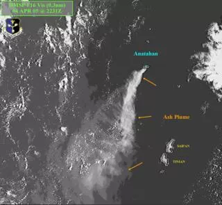
Trajectory analysis SO2 peak west of Hawaii : from Anatahan (788 m), emitted 4 days before? Depending on the intitial height of the backward trajectories, the SO2 could have come from “anywhere” → must be careful !! See also poster of C. Maerker, et al.
Kasatochi eruption – August 2008 In the evening of 7 August 2008 the Kasatochi volcano – located on a small island in the chain of Aleutian Islands – erupted, for the first time since more than 200 years. The eruption released some volcanic ash and very large amounts of SO2 into the atmosphere. The SO2 was blown up into the stratosphere and quickly transported away by the strong winds, across Northern America and Europe. The ash seemed to remain closer to the volcano, though some ash also reached the stratosphere and was subsequently transported by the stratospheric winds. SO2 from OMI and ash from AVHRR (Image source: AVO/USGS)
Kasatochi eruption – August 2008 About 2 hours after the eruption, OMI passed over the volcano and detected a small cloud of SO2 with a peak value of 238 DU !! (Both SCIAMACHY and GOME-2 passed over the area just before the eruption.) The next day, 8 Aug., SACS issued an alert based on SCIAMACHY data, with a peak value of 136 DU. Over the following days, with the cloud stretched and transported by the stratospheric winds, SCIAMACHY data continued to result in many alerts, even when the SO2 had crossed Russia into Asia.
Kasatochi eruption – August 2008 Movie of SO2 data from OMI & GOME-2 on 07 to 24 Aug. 2008
Kasatochi eruption – August 2008 Movie of SO2 data from OMI & GOME-2 on 07 to 24 Aug. 2008
Concluding remarks • Satellite observations of SO2 are a useful addition when monitoring volcanic activity – as support to aviation and to assist volcanological institutes in their monitoring activities (such as via GlobVolcano). • SACS currently uses SCIAMACHY data in near-real time for alerts of “SO2 events” and has an archive for validation and case studies. • SO2 maps of OMI and GOME-2 data are made in near-real time; alert criteria and archive to be implemented in the coming months. • Trajectory analysis in case of an SO2 event and a volcanic ash indicator (based on SEVIRI) to be added in the coming months. • Future extensions of the service – depending on future projects – could include IR data from IASI and AIRS (SO2, ash) and more data products from SEVIRI (e.g. SO2), an aerosol index, hot spots, other trace gases (e.g. BrO, CO2), etc. SACS portal: http://sacs.aeronomie.be/ Data access: http://www.temis.nl/aviation/so2.php