Download
1 / 50
500 likes | 637 Views
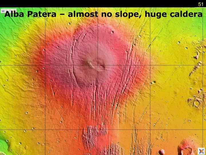
51. Alba Patera – almost no slope, huge caldera. Hellas Planitia 9 km deep 2100 km across rim is 1.25 km high impact debris thrown out to a distance of 4000 km . Argyre Planitia 5 km deep 1800 several deep channels flow into it from surrounding terrain. From high to low – the Planitia.

E N D
51 Alba Patera – almost no slope, huge caldera
Hellas Planitia 9 km deep 2100 km across rim is 1.25 km high impact debris thrown out to a distance of 4000 km Argyre Planitia 5 km deep 1800 several deep channels flow into it from surrounding terrain From high to low – the Planitia 52
Hellas 54 www.astro.virginia.edu/class/oconnell/astr121/im/global-altim-hel-hem.jpg
Valles Marineris • Huge canyon system • 4000 km long • up to 600 km wide • up to 10 km deep (6-7 times deeper than our Grand Canyon) • NOT formed by flowing water! (but possibly modified by water) • How was it formed? 56
The Grand Canyon is a mere scratch inthe ground when compared to theValles Marineris. www.astro.virginia.edu/class/oconnell/astr121/im/ValMar-v-GrCan-TSmith-uwash-enl.jpg 59
How was it formed? • The Valles Marineris is a huge RIP in the crust of Mars. As the Tharsis Plateau rosein elevation, the crust couldn’t stretchenough and simply split wide open. qnck.imageg.net 60
Like the GrandCanyon, therocks in the wallsof the VallesMarineris seem tobe layeredsedimentary rocks. rst.gsfc.nasa.gov/Sect19/FHA-01278sub_bw2b.JPG Unlike the Grand Canyon, however, the VallesMarineris was not cut by running water! (but itlater modified by water.) 62
Landslide 63
Outflow Channels • Near the eastern end of the Valles Marineris are huge canyons called “outflow channels”. • They seem to have been formed when huge amounts of water burst out from behind dams of ice and rock. The flowing water cut the outflow channels in just a few weeks’ time! 64
Why do we think they formed this way? • Here on earth, in Washington State, there are rugged canyon-lands called the Scablands. • The Scablands formed by a process of catastrophic flooding. 67
Catastrophic Flooding • During the last ice age, a glacier flowed across the channel of a river in what is now Washington State. • The ice dammed up the water into a huge lake called Lake Missoula. • Eventually the pressure of the water broke through the ice, releasing hundreds of cubic miles of water all at once. • All this flowing water carved out the Scablands in just a few weeks. 68
www.uwsp.edu/geo/projects/geoweb/participants/dutch/GeoPhotoVtrips/Scablandswww.uwsp.edu/geo/projects/geoweb/participants/dutch/GeoPhotoVtrips/Scablands www.kidscosmos.org/kid-stuff/mars-trip-graphics/flood-channel-map-sml.jpg The Scablands of Washington State, USA 69
Surface Conditions • Surface temperature averages -63oC, but typically varies from -89oC to -31oC. • the Viking landers occasionally measured temperatures > 0oC. • Surface Gravity: 3.7 m/s2 (0.38 G) • Albedo: 0.15 • Solar Irradiance 589 W/m2 (43% of earth) 70
Mars’ Atmosphere • Mars’ atmosphere has almost the same composition as Venus’ atmosphere: 95.3% CO2 and 2.7% N2, with 1.6% Ar and small a amount of O2 (0.13%). 71
Atmospheric Pressure • The pressure of the atmosphere on Mars is only about 7 millibars. The average pressure on Earth is about 1000 millibars. • When the air pressure is this low, liquid water simply boils into water vapor. • This explains why no liquid water can exist on the surface of Mars today. But who knows about under the surface…. 73
Weather Conditions • The “average” temperature on Mars is- 63OC (- 84oF). • The temperature does sometimes rise as high as 80oF, but also falls as low as- 130oF. • With these low temperatures and almost no water vapor, the most common type of “weather” on Mars is dust storms! 74
www.spacescience.org/ExploringSpace/Gallery/MercerPaintings/MarsDustStorm213.JPGwww.spacescience.org/ExploringSpace/Gallery/MercerPaintings/MarsDustStorm213.JPG 77
Precipitation! – NOT! • No precipitation falls on Mars, at least not in the same way it does on Earth - no rain, no snow, no sleet. • Sometimes frost does form on the rocks. 78
Weather Forecast • Despite the very thin atmosphere, Mars has very active weather • Winds of 2 to 30 m/s (67 mph) • Local & planet-wide dust storms • Frost in low-elevation areas • Dust devils • Southern polar cap sublimation of CO2 adds atmosphere in S.H. summer. 81
The Polar Ice Caps • Like Earth, Mars has ice caps at both poles. • The northern ice cap is made up mostly of frozen water ice – just like on earth! • The southern cap, however, is water ice underneath, but there’s a thick layer of dry ice (frozen carbon dioxide) over the normal ice. 84
btc.montana.edu The ice caps shrink and grow with the seasons.All of this material goes into the atmosphere,raising the air pressure in summer. 85
The southern polar cap is nearly allfrozen CO2 June, 2003 Oct, 2003 86
Polar Ice Caps • N. polar cap is a combination of layered water ice and frozen CO2 • S. polar cap is mostly frozen CO2 • Size changes with the seasons 87
Layers result from sublimation and freezing cycles. North polar cap. 89
90 Part of Mars’ atmosphere is lying frozen on its surface! Local winter to summer changes in the south polar “ice” cap (frozen CO2)
There’s lots of evidence for water on Mars…in the past • Old river beds and teardrop-shaped “perched” craters. • Lake beds • Minerals have been found that only form under water. • The Outflow Channels • Sedimentary layers in the walls of the Valles Marineris and many craters. • Gusev Crater! • Here are pictures…. 91
This is the shore ofan ancient lake. Notice the layeringin the rocks! 95
The blueberrieswere found nearMeridiani Planum,the landing site ofNASA’s MarsExploration RoverOpportunity. Image credit: NASA These little nodules are called “blueberries”.They’re made of the mineral hematite that usually forms only underwater. 96
Obvious layeringin the rocksnear the landingsite of NASA’sOpportunityRover. Image Credit: NASA 99